Major road and railway bridges
This table presents the structures with spans greater than 100 meters (non-exhaustive list).
This list of bridges in Slovakia lists bridges of particular historical, scenic, architectural or engineering interest. Road and railway bridges, viaducts, aqueducts and footbridges are included.
This table presents the structures with spans greater than 100 meters (non-exhaustive list).
{{cite web}}: CS1 maint: multiple names: authors list (link)| Structural types |
|  |
|---|---|---|
| Lists of bridges by type | ||
| Lists of bridges by size | ||
| Additional lists | ||
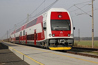
Transport in Slovakia is possible by rail, road, air or rivers. Slovakia is a developed Central European country with a well-developed rail network (3,662 km) and a highway system. Main international airport is the M. R. Štefánik Airport in the capital, Bratislava. Most important waterway is the river Danube used both by passenger, cargo and freight ships. The two most important harbours in Slovakia is Komarno harbour and Bratislava harbour.

Komárno,, colloquially also called Révkomárom, Öregkomárom, Észak-Komárom in Hungarian; is a town in Slovakia at the confluence of the Danube and the Váh rivers. Historically it was formed by the "old town" on the left bank of Danube, present day Komárno in Slovakia, and by a "new town" on the right bank, present day Komárom in Hungary, which were historically one administrative unit. Following World War I and the Treaty of Trianon, the border of the newly created Czechoslovakia cut the historical, unified town in half, creating two new independent towns in two countries. Komárno and Komárom are connected by the Elisabeth Bridge, which used to be an official border crossing between Slovakia and Hungary until border checks were lifted due to the Schengen Area rules. In 2020, a new road bridge was opened.
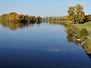
The Váh is the longest river within Slovakia. Towns on the river include Liptovský Hrádok, Liptovský Mikuláš, Ružomberok, Vrútky, Žilina, Bytča, Považská Bystrica, Púchov, Ilava, Dubnica nad Váhom, Nemšová, Trenčín, Nové Mesto nad Váhom, Piešťany, Hlohovec, Sereď, Šaľa, Kolárovo and Komárno.
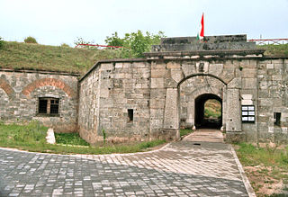
Komárom is a city in Hungary on the south bank of the Danube in Komárom-Esztergom County. Komárno, Slovakia, is on the northern bank. Komárom was formerly a separate village called Újszőny. In 1892 Komárom and Újszőny were connected with an iron bridge and in 1896 the two towns were united under the name city of Komárom. The fortress played an important role in the Hungarian Revolution of 1848 and many contemporary English sources refer to it as the Fortress of Comorn.

The Nitra Region is one of the administrative regions of Slovakia. It was first established in 1923 and from 1996 exists in its present borders. It consists of seven districts and 354 municipalities, from which 16 have a town status. The economy of the region focuses more on agriculture, than in other Slovak regions. Nitra is its seat, largest city, and cultural and economic center.

The Little Danube is a branch of the river Danube in Slovakia.

The Little Hungarian Plain or Little Alföld is a plain of approximately 8,000 km² in northwestern Hungary, south-western Slovakia, and eastern Austria. It is a part of the Pannonian plain which covers most parts of Hungary.

Štúrovo is a town in Slovakia, situated on the River Danube. Its population in 2018 was 10,279.

The Mária Valéria Bridge joins Esztergom in Hungary and Štúrovo in Slovakia, across the River Danube. The bridge is some 500 metres in length. It is named after Archduchess Marie Valerie of Austria (1868–1924), the fourth child of the Emperor of Austria-Hungary, Franz Josef and Elisabeth.

The Gabčíkovo–Nagymaros Dams is a large barrage project on the Danube. It was initiated by the Budapest Treaty of 16 September 1977 between the Czechoslovak Socialist Republic and the Hungarian People's Republic. The project aimed at preventing catastrophic floods, improving river navigability and producing clean electricity.

The Port of Bratislava is a major port on the river Danube and — in a wider sense — on the Rhine-Main-Danube waterway, located in Bratislava, the capital of Slovakia. It is a universal inland port consisting of two parts, a cargo port and a passenger port. The former is a key facility for Slovakia's economy as the largest of three international ports in Slovakia, the others being in Komárno and Štúrovo. The port lies at the strategic intersection of the Rhine-Main-Danube Canal with the Baltic-Adriatic Corridor, part of the Trans-European Transport Networks, and it is located near two major ports: Port of Vienna and Port of Budapest.

Rail transport in Slovakia began on 21 September 1840, with the opening of the first horse-powered line from Bratislava to Svätý Jur. The first steam-powered line, from Bratislava to Vienna, opened on 20 August 1848.

Bratislava is the capital and largest city of Slovakia. Officially, the population of the city is about 475,000; however, it is estimated to be more than 660,000 — approximately 140% of the official figures. Bratislava is in southwestern Slovakia at the foot of the Little Carpathians, occupying both banks of the River Danube and the left bank of the River Morava. Bordering Austria and Hungary, it is the only national capital that borders two sovereign states.

The Danube is a river that was once a long-standing frontier of the Roman Empire and today connects 10 European countries, running through their territories or being a border. Originating in Germany, the Danube flows southeast for 2,850 km (1,770 mi), passing through or bordering Austria, Slovakia, Hungary, Croatia, Serbia, Romania, Bulgaria, Moldova, and Ukraine before draining into the Black Sea. Its drainage basin extends into nine more countries. The largest cities on the river are Vienna, Budapest, Belgrade and Bratislava, all of which are the capitals of their respective countries. The Danube passes through four capital cities, more than any other river in the world. Five more capital cities lie in the Danube's basin: Bucharest, Sofia, Zagreb, Ljubljana and Sarajevo. The fourth-largest city in its basin is Munich, the capital of Bavaria, standing on the Isar River.
Zoltán Agócs was an architect and professor from Czechoslovakia with Hungarian ancestry.

Clark Ádám is a crane vessel, specifically a floating sheerleg, built in 1980 in Budapest, Hungary, by the Hungarian Shipyards and Crane Factory Angyalföld Division. It originally had a lifting capacity of 120 metric tons, gradually raised to 200 tons by 2006, making it one of the largest in lifting capacity on Central European rivers. It is mainly used for building bridges, but is also commissioned to assist salvage operations, as well as to launch hydrofoils. It has rescued several ships; in 2019 it raised the sunken Hableány from the Danube at Budapest. The vessel is named after Scottish engineer Adam Clark (1811–1866).

The Komárno - Komárom International Street Run is a run traditionally held between the Slovak Komárno and Hungarian Komárom between April and May.


