There are currently six bridges over the Danube river in Bratislava, the capital of Slovakia. Five of them are currently used for traffic, while one of them is for pedestrians and trams.[1]
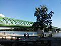
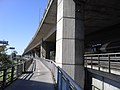
Lanfranconi is the first bridge in Bratislava made of concrete.[2] It is also a part of the D2 highway. It was built within 1985–1991.[3] The highest average number of cars crossing the bridge daily was measured to be around 75000 in 2020, peaking at around 106 000.[4] The priority of the design was aimed to be clean, not interruptive to the surrounding nature by its shape, not blocking any view of the city by its body structure, while being in harmony with the already existing bridge at that time – SNP Bridge.
The Lanfranconi Bridge is 761 metres long. There is a four-lane roadway, together 30 metres wide.
Lanfranconi Bridge
Underneath the roadway, there are also footbridges for pedestrians and bikers on both sides. Inside the bridge, there is a waterpipe and a gas pipeline going through.[5][6]
Lanfranconi
Lanfranconi
Lafranconi
pedestrians
yes
cars
yes
buses
yes
bikes
yes
trams
no
trains
no
gas or water pipelines
yes
The name of the bridge
The original name was supposed to be Most mládeže - Bridge of Youth,[7] however, it finally got named Lanfranconi after Count Enea Grazioso Lanfranconi, a famous, originally Italian, builder in Bratislava who owned a mansion situated nearby the bridge today hosting Comenius University premises. [8][9]
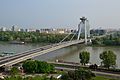
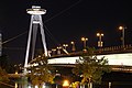
SNP Bridge
Northwest view of the Slovak National Uprising Bridge
From 1993 to 2012 the bridge was named Nový Most - New Bridge. It is made of steel, a fan-shaped design suspended bridge. It is the only bridge in Bratislava to have no single pillar inside the Danube River.[10] It is the biggest bridge in Bratislava. In 2002 it was named a Century Building in Slovakia in the category Bridge Constructions. The SNP Bridge belongs to the association World Federation of Great Towers.[11] Since May 2018 it is also a National Culture Heritage site.[6]
For the sake of building this bridge, a few historic sites were destroyed – a part of the Bratislava Castle structures, historically important parts of Vydrica, Rybné Námestie - Fish Square and Bratislava's Neolog Moorish synagogue.[10][11] This bridge, however, helped to speed up the traffic and also helped the development of Petržalka District.
The length of this bridge is 430.8 metres. The height is 95 metres. The diameter of the dome is 32 metres.
The bridge has two of the two-lane roadways, and has pedestrians and cyclist sections underneath on both sides.
In the category of suspended bridges, it gained fourth place in 1972.[10] However, it is on top of the world's bridges with only one single pylon and only one single hanging plane.[6] Inside the bridge there is a waterpipe, the supplying Old Town and Petržalka districts.
Most SNP, Bratislava (by Pudelek)
Bratislava - Most SNP (7)
Bratislava - Most SNP (3)
Pedestrian section of Most SNP, Bratislava, Slovakia
Bratislava Neolog synagogue destroyed for the sake of SNP Bridge[12]
SNP
pedestrians
yes
cars
yes
buses
yes
bikes
yes
trams
no
trains
no
gas or water pipelines
no
UFO Restaurant
Tourism
An interesting tourist place is the restaurant on the top of the SNP Bridge's pylon placed in the height of 95 metres. The restaurant, opened on the 26th of August 1972 has 2 bars and a capacity of 200 people, and is most importantly named UFO (formerly Bystrica) thanks to its shape.[10][11] The restaurant is connected with the observation platform, from where the visibility can be up to 100 kilometres. An elevator which can take you to the bar in 45 seconds is placed in the eastern pillar, while the western pillar contains emergency stairs.[5][6][10]
Interesting facts
Since 2016, the bridge can tell the weather for the next day with light signals. The lights are turned on in the evening, red is for windy weather, green is for cloudy or foggy weather, yellow is for sunny weather and blue is for rainy weather. The bridge reports the weather every 15 minutes with the certain color being on for 5 minutes. The lighting is provided information by the meteorological systems and is done by 24 LED reflectors placed on the restaurant.[11]
Old Bridge - Starý Most
Former names: Bridge of Franz Joseph; after the First World War Štefánik´s Bridge; after Second World War Bridge of Red Army.
Despite the short existence of a bridge from 15th century, the first bridge in Bratislava was the Bridge of Carolina Augusta, built in 1825 made of pontoon, after the previous wooden bridges wouldn't last too long. This one lasted until 1891. New bridge was built 1889 - 1890 named after Franz Joseph I. It was a combined bridge for road traffic, railway and pedestrian. In times of the First Czecho-Slovak Republic it was named Štefánik's Bridge and a railway went through into Vienna.[6]
From 2014 to 2016 there was a great reconstruction held. On the Danube's floor underneath the bridge were found two objects that were in fact an ammunition, so the repairs were postponed.
The bridge is today open for pedestrians, cyclists and tram transportation.[5]
Old Bridge
Old Bridge
Bratislava Stary most Helicopter
Bratislava ships under Starý Most
Old Bridge - Starý Most
pedestrians
yes
cars
no - with the exception of emergency vehicles
buses
no - with exception of one line
bikes
yes
trams
yes
trains
no
gas or water pipelines
no
Apollo Bridge
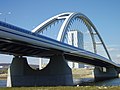
The Apollo Bridge is an arched bridge, located between the Old Bridge and the Harbour Bridge. The full length is 835 metres, height of the arch is 36 metres. The bridge has 20 pillars. The Apollo Bridge was nominated by the American Technical Engineering Society along with four other world-class buildings at the prestigious Opal Awards in 2006. It was the only European building to be nominated that year.
The bridge was named after a refinery that once stood nearby, which was named after the deity of Apolon. The bridge was built between 2002 - 2005. It was built on floating pontoons.[5]
Apollo bridge at night
Apollo bridge1
Apollo bridge
Apollo bridge
Apollo
pedestrians
yes
cars
yes
buses
yes
bikes
yes
trams
no
trains
no
gas or water pipelines
yes
Harbour Bridge - Prístavný Most
Originally named Bridges of Dukla Heroes, the bridge is a two-floor, railway and highway bridge close to the Bratislava's Port. It is a part of the D1 motorway. Its length is 599,4 metres. There is also a pedestrian and cyclist section, water pipeline, gas pipeline and others. It was built within 1977 – 1985. Every day, 120.000 vehicles cross the bridge. It is the city's busiest bridge.[5]
Cyclist route in Harbour Bridge
Bratislava
Prístavný most panorama
Winter Harbour and the Harbour Bridge
Harbour Bridge - Prístavný Most
pedestrians
yes
cars
yes
buses
yes
bikes
yes
trams
no
trains
yes
gas or water pipelines
yes
Floodplain Bridge - Lužný Most
The newest bridge of all, its construction started in 2018. It was opened to the public on the 26th of September 2021.[13] The bridge consists of multiple bridges connecting multiple arms of the river Danube and it is a part of the D4 motorway. It is 2928 meters long and 35 meters wide. The name was chosen by the people on a poll by the Ministry of Transport and Construction of Slovakia in 2020. The suggested name Lužný most, named after the rare landscape of Riparian forests (Slovak: Lužné lesy) nearby, won the poll with more than 50 000 votes.
Lužný most
Floodplain Bridge - Lužný Most
pedestrians
no
cars
yes
buses
yes
bikes
yes
trams
no
trains
no
gas or water pipelines
-
Red Bridge - Červený Most
Red Bridge, Bratislava
A railway bridge located in the district of Mlynská Dolina crossing the spring valley of Vydrica stream. It was built in 1848. It is 215 metres long. Originally, it was a brick bridge supported by nine arches until the German army destroyed it in 1945, with a fragment of a pillar remaining intact. The current bridge was rebuilt in 1948 in a steel version, carrying the same name and painted red. This railway bridge is a part of the historically important railway route connecting Bratislava with Vienna.[14]
This page is based on this Wikipedia article Text is available under the CC BY-SA 4.0 license; additional terms may apply. Images, videos and audio are available under their respective licenses.