This is a list of bridges and viaducts in Norway, including those for pedestrians and vehicular traffic.
This table presents the structures with spans greater than 200 meters (non-exhaustive list).
| Name | Span | Length | Type | Carries Crosses | Opened | Location | County | Ref. | ||
|---|---|---|---|---|---|---|---|---|---|---|
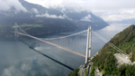
| 1 | Sognefjorden Bridge | 3,700 m (12,100 ft) | Suspension | Lavik – Gulen Municipality 61°04′39.3″N5°30′07.3″E / 61.077583°N 5.502028°E | Vestland | [11] | ||||
| 2 | Julsund Bridge | 1,625 m (5,331 ft) | 2,010 m (6,590 ft) | Suspension | 2035 | Molde – Otrøya 62°44′00.6″N6°57′10.5″E / 62.733500°N 6.952917°E | Møre og Romsdal | [12] [13] | ||
| 3 | Bjørnafjord Bridge | 450 m (1,480 ft) | 5,475 m (17,963 ft) | Cable-stayed 450+325 | 2030 | Søre Øyane – Tysnesøy 60°06′30.4″N5°21′44.4″E / 60.108444°N 5.362333°E | Vestland | [S 43] [14] |
A
B
D
E
F
G
H
I
J
K
L
M
N
O
P
R
S
T
U
V
W
Å
| Structural types |
|  |
|---|---|---|
| Lists of bridges by type | ||
| Lists of bridges by size | ||
| Additional lists | ||
| Related | ||

Nordland is one of the three northernmost counties in Norway in the Northern Norway region, bordering Troms in the north, Trøndelag in the south, Norrbotten County in Sweden to the east, Västerbotten County to the south-east, and the Atlantic Ocean to the west. The county was formerly known as Nordlandene amt. The county administration is in the town of Bodø. The remote Arctic island of Jan Mayen has been administered from Nordland since 1995. In the southern part of the county is Vega, listed on the UNESCO World Heritage Site list.

European route E6 is the main north-south thoroughfare through Norway as well as the west coast of Sweden. It is 3,056 km (1,899 mi) long and runs from the southern tip of Sweden at Trelleborg, into Norway and through almost all of the country north to the Arctic Circle and Nordkapp. The route ends in Kirkenes close to the Russian border.

The Rauma Line is a 114.2 kilometres (71.0 mi) long railway between the town of Åndalsnes, and the village of Dombås, in Norway. Running down the Romsdalen valley, the line opened between 1921 and 1924 as a branch of the Dovre Line, which connects to the cities of Oslo and Trondheim. Originally intended as the first stage to connect Ålesund, and possibly also Molde and Kristiansund, no extensions have ever been realized. The unelectrified line is served four times daily with SJ Norge's Class 93, although in the summer the service only operates from Åndalsnes to Bjorli as a tourist service. CargoLink operates a daily freight train.
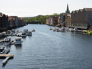
Nidelva is a river in Trondheim Municipality in Trøndelag county, Norway. The name of the 30-kilometre (19 mi) long river translates to "the River Nid" since the suffix elva or elven is the Norwegian word for "the river".
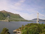
The Sundøy Bridge is a cantilever bridge in the municipality of Leirfjord in Nordland county, Norway. The concrete bridge connects the mainland to the village of Sundøy on the island of Alsta. The 538-metre (1,765 ft) bridge has three spans, with the main span being 298 metres (978 ft) long. The maximum clearance to the sea is 43.5 metres (143 ft).

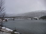
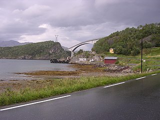
The Folda Bridge is a suspension bridge in Nærøysund municipality in Trøndelag county, Norway. The bridge crosses the Foldereidsundet strait which is part of the inner-Foldafjord. The bridge is 336 metres (1,102 ft) long, the main span is 225 metres (738 ft), and the maximum clearance below the bridge 38 metres (125 ft). At the northern end of the bridge, the road enters a 230-metre (750 ft) long tunnel through a mountain before entering the village of Foldereid. The bridge was completed in 1969.

The Skodje Bridge is a bridge that crosses the Skodjestraumen in Ålesund Municipality in Møre og Romsdal county, Norway. It is located 5 kilometres (3.1 mi) south of the village of Tennfjord, 3.5 kilometres (2.2 mi) west of Skodje, and 4.5 kilometres (2.8 mi) northwest of Valle.
Brevik Bridge is one of two bridges that span the mouth of the Frierfjord. It connects the municipalities of Bamble and Porsgrunn in Telemark county. On the west side, in Bamble, lies the town of Stathelle, while on the east side lies the town of Brevik in Porsgrunn.

Grenland Bridge is Norway's highest cable-stayed bridge with a tower height of 168 metres (551 ft). The bridge, which opened in 1996, is part of the European Route E18 highway and it crosses the Frierfjord, a fjord in Telemark county. The bridge connects the town of Brevik in Porsgrunn Municipality to the town of Stathelle in Bamble Municipality. When built, it replaced Brevik Bridge (Breviksbrua) as the primary route across the fjord.

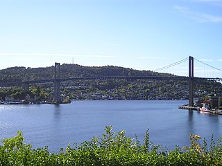
Elgeseter Bridge is a bridge in the city and municipality of Trondheim in Trøndelag county, Norway. It is part of the European route E6 highway which passes over the Nidelva river and connects Prinsens street in the Midtbyen area of Trondheim with Elgeseter street in the Elgeseter area of Trondheim in the south. The Trondheim city council decided on 17 March 1949 that the bridge should be built. Elgeseter bridge was opened in 1951 after a construction period of 2 years.

Old Town Bridge is located in Trondheim, Trøndelag County, Norway.

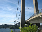
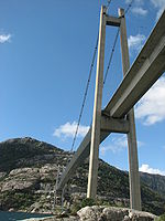
Lysefjord Bridge Norwegian: Lysefjordbrua is a suspension bridge over the Lysefjorden in Rogaland county, Norway. The bridge connects the municipalities of Strand and Sandnes. Construction on the 639-metre-long (2,096 ft) bridge began in 1995 and was finished in 1997 at a cost of 150 million kr.
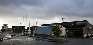
Sandnessjøen Airport is a regional airport serving the town of Sandnessjøen, Norway. The airport is located in the municipality of Alstahaug in Nordland county, 5.5 nautical miles south west of Sandnessjøen. In 2014, Sandnessjøen Airport served 74,138 passengers. It is operated by Avinor.

The Brevik Line is a 10-kilometer (6.2 mi) railway which runs from Eidanger to Brevik in Porsgrunn, Norway. The single track and electrified branch line of the Vestfold Line is exclusively used for freight traffic to Norcem Brevik hauled by CargoNet.
Partsrederiet Kystekspressen ANS branded as Kystekspressen or the Coast Express is a shipping company that operates passenger ferry services between Trondheim and Kristiansund, Norway. Three ships are used on the route, that includes the branch lines Trondheim–Sula and Sistranda–Halten. It had 343,510 passengers in 2005.
Dr. ing. A. Aas-Jakobsen AS, trading as Aas-Jakobsen, is a civil engineering consultant company specializing in structural engineering. The company is based in Oslo, Norway, and primarily works with bridges, roads, railways, offshore oil and buildings. The company has 250 employees. The company was established by Andreas Aas-Jakobsen (1905–1980) in 1937. For the first decade, the company specialized in shell structures, but from the 1950s, the company shifted to bridge design. The company later started designing offshore installations and became a verifier for such structures, and later also became a consultant for railway projects and major road projects, such as the Bjørvika Tunnel through Oslo.

Bakklandet is a neighborhood in the city of Trondheim in Trøndelag county, Norway. It lies in the borough of Østbyen on the east side of the Nidelva river between the Bakke Bridge and the Old Town Bridge.

Foldereid is a former municipality in the northern part of the old Nord-Trøndelag county in Norway. The 513-square-kilometre (198 sq mi) municipality existed from 1886 until its dissolution in 1964. The municipality encompassed the area surrounding the inner part of the Folda fjord, the Innerfolda in what is now the municipalities of Nærøysund and Høylandet in Trøndelag county. The village of Foldereid, where the Foldereid Church is located, was the administrative centre of the municipality.

Road tolling to finance bridges, tunnels and roads has a long history in Norway. The cities Oslo, Bergen and Trondheim introduced toll rings between 1986 and 1991 as a means to discourage urban traffic and to finance infrastructure projects around those cities. Today toll rings circumscribe Oslo, Kristiansand, Stavanger, Haugesund, Bergen, Askøy, Bodø, Harstad, Grenland, Førde and Trondheim. Besides toll rings, road tolls are installed to finance certain road projects, and often also on the existing road to discourage people from using it. Some tolls use congestion pricing and/or environmentally differentiated toll rates.