Alsta

Last updated
Alsta
Sju sostre in Alsta, 06 2011.jpg
Alsta
Other namesAlsten (historic name)
Alstein (historic name)
Geography
Location Nordland, Norway
Coordinates 65°58′00″N12°36′53″E / 65.96667°N 12.614722°E / 65.96667; 12.614722
Area152.6 km2 (58.9 sq mi)
Length30 km (19 mi)
Width8 km (5 mi)
Highest elevation1,072 m (3517 ft)
Highest pointBotnkrona
Administration
Norway
County Nordland
Municipalities Alstahaug Municipality and Leirfjord Municipality
Demographics
Population6,969 (2017)

Alsta [1] is an island in Alstahaug Municipality and Leirfjord Municipality in Nordland county, Norway. The island is surrounded by the Vefsnfjorden to the east, the Leirfjorden to the north, and the Alstenfjorden to the south and west. The eastern part of the island is dominated by the Seven Sisters mountain range (Norwegian : De syv søstre) which has five mountains that are more than 1,000 metres (3,300 ft) tall, while the western part of the island is relatively flat and it is the location of the town of Sandnessjøen and the village of Søvika in the south. Historically, the island was known as Alsten or Alstein. [2] [1]
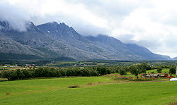
Lowland near the Seven Sisters mountains Alsten.jpg
Lowland near the Seven Sisters mountains

The 30-kilometre (19 mi) long island has an area of 152.6 square kilometres (58.9 sq mi), and its highest point is the mountain Botnkrona, which reaches 1,072 metres (3,517 ft) above sea level. In 2017, there were 6,969 residents on the island. [2] The islands of Altra and Skålværet lie to the southwest, the islands of Tjøtta, Offersøya, Mindlandet, and Rødøya lie to the south, surrounding the entrance to the Vefsnfjorden.

The island is connected to the mainland by the Helgeland Bridge on Norwegian County Road 17, which connects the northern part of the island to Leirfjord Municipality on the mainland. This same highway 17 continues across the island from north to south where it then connects by bridge to the nearby islands of Offersøya and Tjøtta.

The eastern part of the island is often called the "backside" of the island since it is on the other side of the mountains from the more populous side. This "backside" lies inside Leirfjord Municipality and the Sundøy Bridge connects the Sundøya village area on the backside of the island to the mainland. [2]

See also

Related Research Articles

<span class="mw-page-title-main">Alstahaug Municipality</span> Municipality in Nordland, Norway

Alstahaug is a municipality in Nordland county, Norway. It is part of the Helgeland region. The administrative centre of the municipality is the town of Sandnessjøen. Some of the villages in Alstahaug include Søvika and Tjøtta.

<span class="mw-page-title-main">Leirfjord Municipality</span> Municipality in Nordland, Norway

Leirfjord is a municipality in Nordland county, Norway. It is part of the Helgeland traditional region. The administrative centre of the municipality is the village of Leland. Other villages in Leirfjord include Bardal and Sundøya. The large Helgeland Bridge is partly located in the municipality, connecting it to Alstahaug Municipality and the town of Sandnessjøen.

Sundøya is a village in Leirfjord Municipality in Nordland county, Norway. The village is located about 5 kilometres (3.1 mi) south of the village of Leland. Sundøya has a population of about 120 people. It is located on the north side of the Vefsnfjorden on the northeastern part of the island of Alsta, east of the Seven Sisters mountains, which isolate it from the rest of the island. Since Sundøy is surrounded by mountains and water, it was only accessible by boat until 2003 when the Sundøy Bridge was built, providing a road connection to the mainland of Leirfjord Municipality.

<span class="mw-page-title-main">Sundøy Bridge</span> Bridge in Leirfjord Municipality, Norway

The Sundøy Bridge is a cantilever bridge in Leirfjord Municipality in Nordland county, Norway. The concrete bridge connects the mainland to the village of Sundøya on the island of Alsta. The 538-metre (1,765 ft) bridge has three spans, with the main span being 298 metres (978 ft) long. The maximum clearance to the sea is 43.5 metres (143 ft).

<span class="mw-page-title-main">Vefsnfjorden</span> Fjord in Nordland, Norway

Vefsnfjorden is a fjord in the traditional district of Helgeland in Nordland county, Norway. It is about 51 kilometres (32 mi) long, reaching a maximum depth of about 440 metres (1,440 ft) below sea level. The fjord flows through Alstahaug Municipality, Leirfjord Municipality, and Vefsn Municipality.

<span class="mw-page-title-main">Kågen</span> Island in Skjervøy, Norway

Kågen (Norwegian) or Gávvir (Northern Sami) is an island in Skjervøy Municipality in Troms county, Norway. The 85.7-square-kilometre (33.1 sq mi) island lies between the Kvænangen fjord and the Lyngen fjord to the west. The island is home to 27 inhabitants (2001). The island is mountainous with several peaks over 1,000 metres (3,300 ft) above sea level. The highest point is the 1,228-metre (4,029 ft) tall mountain Store Kågtind. Kågen is the 52nd largest island in Norway.

Tjøtta is a village in Alstahaug Municipality in Nordland county, Norway. It is located on the southern tip of the island of Tjøtta, which is located south of the large island of Alsta. The village is located on an island, but it does have a mainland road connection via Norwegian County Road 17 and a series of bridges heading north to the town of Sandnessjøen. The historic Tjøtta Church is located in the village.

Langøya is the third largest island of Norway, with an area of 850.2 square kilometres (328.3 sq mi). The island is a part of the Vesterålen archipelago in Nordland county, Norway. The island includes Bø Municipality and Øksnes Municipality as well as parts of Sortland Municipality and Hadsel Municipality.

<span class="mw-page-title-main">Bremangerlandet</span> Island in Norway

Bremangerlandet is an island in Bremanger Municipality in the traditional district of Nordfjord in Vestland county, Norway. The 153-square-kilometre (59 sq mi) island is one of the largest islands in the county. The highest point on the island is the 889-metre (2,917 ft) tall mountain Svartevassegga, however the cliff at Hornelen, located 1 kilometre (0.62 mi) to the east, is more well-known and has an elevation of 860 metres (2,820 ft). The 4-kilometre (2.5 mi) long lake Dalevatnet is located in the central part of the island.

<span class="mw-page-title-main">Tjøtta (island)</span> Island in Nordland county, Norway

Tjøtta is an island in Alstahaug Municipality in Nordland county, Norway. The 11.3-square-kilometre (4.4 sq mi) island lies at the entrance to the Vefsnfjorden, just south of the island of Alsta. The U-shaped island is relatively flat, and the highest point is the 77-metre (253 ft) tall Kalvberghaugen, just east of the village of Tjøtta. The island has two main villages on it: Tjøtta and Svinnes. The Norwegian County Road 17 crosses the island and it connects it to the neighboring islands of Offersøya and Alsta by two causeways.

<span class="mw-page-title-main">Leirfjorden</span> Fjord in Nordland, Norway

Leirfjorden is a fjord in Leirfjord Municipality and Alstahaug Municipality in Nordland county, Norway. The 20-kilometre (12 mi) long fjord is located east of the town of Sandnessjøen, between the mainland and the island of Alsta. There is a short strait that connects it to the Vefsnfjorden to the south.

Åmøya is an island in Meløy Municipality in Nordland county, Norway. The 23.4-square-kilometre (9.0 sq mi) island lies west of the mainland, east of the island of Bolga, and south of the island of Meløya. The island is connected to the mainland by a series of small bridges over the island of Grønnøya and several other small islands between Åmøya and the village of Engavågen on the mainland. The island is very mountainous, the highest mountain is the 648-metre (2,126 ft) Risnestinden. There were 112 residents living on the island in 2016.

<span class="mw-page-title-main">Andørja (island)</span> Island in Troms, Norway

Andørja (Norwegian) or Áttir (Northern Sami) is an island in Ibestad Municipality in Troms county, Norway. The 135-square-kilometre (52 sq mi) island lies about 25 kilometres (16 mi) east of the town of Harstad. The island is located entirely within Ibestad Municipality, although the island itself was a separate municipality from 1926 until 1964. The largest population area on Andørja island is the Å - Ånstad - Laupstad area on the west coast with 205 residents (2001). Andørja Church is located in Engenes on the northwestern tip of the island.

<span class="mw-page-title-main">Tjøtta Municipality</span> Former municipality in Nordland, Norway

Tjøtta is a former municipality in Nordland county, Norway. The 326-square-kilometre (126 sq mi) municipality existed from 1862 until its dissolution in 1965. The municipality was centered around the island of Tjøtta plus the mainland to the east and south as well as over 3000 islands, islets, and skerries to the west. The administrative centre of Tjøtta was the village of Tjøtta, located on the island of Tjøtta, where the Tjøtta Church is located.

<span class="mw-page-title-main">Dønna (island)</span> Island in Dønna, Norway

Dønna is the largest island in Dønna Municipality in Nordland county, Norway. The 138-square-kilometre (53 sq mi) island lies off the west coast of the mainland of Helgeland, Norway. The islands of Løkta and Tomma lie northeast of the island, the islands of Vandve and Åsværet lie to the west, and the islands of Herøy and Alsta lie to the south.

Vega is an island in Vega Municipality in Nordland county, Norway. The 108-square-kilometre (42 sq mi) island is the largest island in the 6,500 islands in the Vegaøyan archipelago, all of which is a UNESCO World Heritage Site. The island lies in the Norwegian Sea, about 18 kilometres (11 mi) west of the mainland of Norway. The islands of Igerøya and Ylvingen lie between Vega and the mainland. The main villages on the island are Gladstad, the administrative centre of the municipality, and Holand.

<span class="mw-page-title-main">Mindlandet</span> Island in Nordland, Norway

Mindlandet is an island in Alstahaug Municipality in Nordland county, Norway. The 13.8-square-kilometre (5.3 sq mi) island lies at the mouth of the Vefsnfjorden, just south of the islands of Tjøtta and Rødøya. The island is fairly flat, and has a lot of very good agricultural land.

Offersøya is an island in Alstahaug Municipality in Nordland county, Norway. The 6.7-square-kilometre (2.6 sq mi) island lies directly between the large island of Alsta and the smaller island of Tjøtta at the mouth of the Vefsnfjorden. The Norwegian County Road 17 runs across the island connecting Alsta and Tjøtta. The island is relatively flat, with the highest point only reaching 43 metres (141 ft) above sea level. In 2016, there were 61 residents living on the island.

<span class="mw-page-title-main">Rødøya, Alstahaug</span> Island in Nordland, Norway

Rødøya is an island in Alstahaug Municipality in Nordland county, Norway. The 7.3-square-kilometre (2.8 sq mi) island lies at the mouth of the Vefsnfjorden and the Halsfjorden. The island is home to 23 people, living mostly on the southern part of the island.

Altra is an island in Alstahaug Municipality in Nordland county, Norway. The 0.24-square-kilometre (59-acre) island lies between the large island of Alsta and the small island of Tenna. The flat island is rather unusual in the area because it is about 12 kilometres (7.5 mi) long and at most about 2 kilometres (6,600 ft) wide at the northern end. Most of the island is very narrow, and in some places, it is only about 60 metres (200 ft) wide.

References

  1. 1 2 "Stadnamn og skrivemåten for stadnamn" (in Norwegian). Kartverket. Retrieved 2019-02-23.
  2. 1 2 3 Thorsnæs, Geir, ed. (2018-11-14). "Alsta". Store norske leksikon (in Norwegian). Kunnskapsforlaget . Retrieved 2019-02-23.