Nordland is a county in Norway in the Northern Norway region, bordering Troms in the north, Trøndelag in the south, Norrbotten County in Sweden to the east, Västerbotten County to the southeast, and the Atlantic Ocean to the west. The county was formerly known as Nordlandene amt. The county administration is in Bodø. The remote Arctic island of Jan Mayen has been administered from Nordland since 1995.

The Ranfjorden is a fjord in the Helgeland district of Nordland county, Norway. The largest part of the fjord is in the municipality of Rana, but the fjord also passes through the municipalities of Hemnes, Vefsn, Leirfjord, Nesna, and Dønna. The river Ranelva meets the Ranfjord in at the town of Mo i Rana at the innermost part of the fjord. It then flows to the west for about 68 kilometres (42 mi) to where it meets the sea along the border of Dønna and Nesna municipalities.

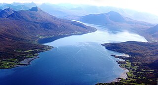
The Vefsnfjord or Vefsnfjorden is a fjord in the Helgeland traditional district of Nordland county, Norway. It is about 51 kilometres (32 mi) long, reaching a maximum depth of about 440 metres (1,440 ft) below sea level. The fjord flows through the municipalities of Alstahaug, Leirfjord, and Vefsn.
Sørfjorden or Sørfjord is the name of several fjords on the coast of Norway.

Haus or Hausvik is a village in Osterøy municipality in Hordaland county, Norway. The village is located on the southwestern coast of the island of Osterøy along the Sørfjorden. The village lies across the Sørfjorden from the villages of Ytre Arna and Garnes. The village of Valestrandfossen lies about 7 kilometres (4.3 mi) north along the fjord. The 0.38-square-kilometre (94-acre) village has a population (2013) of 619, giving the village a population density of 1,629 inhabitants per square kilometre (4,220/sq mi).

Innværfjorden is a small fjord in the municipality of Bømlo in Hordaland county, Norway. It lies on the south of the village of Rubbestadneset on the eastern side of the island of Bømlo. The 3.5-kilometre-long (2.2 mi) fjord flows to the west from the Stokksundet strait.
Søre Øyane is a village in the municipality of Os in Hordaland county, Norway. It is located on an archipelago in the Bjørnafjorden, off the southwestern coast of Os, southeast of the larger island of Strøno. The archipelago consists of four major islands, Røtinga, Bruarøy, Sundøy, and Lepsøy, as well as several smaller islands and islets, many of which are uninhabited. Lepsøy, the northernmost island, is located adjacent to the mainland, which it is connected to by a short bridge. A longer bridge spans the strait between Lepsøy and Sundøy, which in turn is connected to Røtinga and a smaller island, Brattholmen, through Bruarøy.

Askøy is an island in Hordaland county, Norway. The 90-square-kilometre (35 sq mi) island is located entirely inside the municipality of Askøy, and the island makes up about 88% of the municipal area and is home to about 96% of the municipal residents. In 2014, there were 26,230 people living on the island. Since the opening of the Askøy Bridge leading to the mainland in the city of Bergen in 1992, the population has increased rapidly. The island is named after the old Ask farm along the eastern coast of the island. The village is the site of the old Ask Church.

Tresfjorden is a fjord in Vestnes Municipality in Møre og Romsdal county, Norway. The 12-kilometre (7.5 mi) long fjord branches off of the main Romsdal Fjord, and it is one of the two main fjords that cut into the municipality. The village of Vestnes sits at the mouth of the fjord and the village of Vikebukt sits at the mouth of the fjord. The village of Tresfjord is located at the southern end of the fjord.

Austfjorden is a fjord in Hordaland county, Norway. The 20-kilometre (12 mi) long fjord runs along the border between the municipalities of Lindås and Masfjorden. It starts in Lindås and extends to the northwest. The Masfjorden joins the Austfjorden from the north, and then the Austfjorden empties into the Fensfjorden before reaching the open sea near Fedje. The Austfjorden is the innermost arm of the Fensfjorden. The village of Knarrviki and the Mongstad industrial area lie on the western shore of the Austfjorden. The village of Myking lies on the western shore of the fjord, near the innermost part of the fjord.
Bardalssjøen or Bardal is a village in the municipality of Leirfjord in Nordland county, Norway. The village is located along the south coast of the Ranfjorden, about 10 kilometres (6.2 mi) west of the village of Hemnesberget. The village surrounds the Bardalselva river which flows into the fjord. The Bardal Church was built in 1887 on a hill near the mouth of the river. The Bardal area has historically been part of both Nesna Municipality and Hemnes Municipality, but it has been part of Leirfjord Municipality since 1964.

Sørfolda is a fjord in Nordland county, Norway. It is located in the municipalities of Sørfold and Bodø. The 40-kilometre (25 mi) Sørfolda is a southeastern branch of the main Folda fjord. Side branches include the Nevelsfjorden, Eidekjosen, Skjunkfjorden, and Leirfjorden. The deepest part of the fjord reaches 573 metres (1,880 ft) below sea level.
Balsfjorden (Norwegian) or Báhccavuotna (Northern Sami) is a fjord in Troms county, Norway. The 57-kilometre (35 mi) long fjord runs through the municipalities of Balsfjord and Tromsø. It branches off the Tromsøysundet strait just south of the city of Tromsø and it flows in a north-south direction, ranging from 2 to 7 kilometres wide. The European route E8 highway follows most of the eastern shore of the fjord and the European route E6 highway runs along the southern end of the fjord. The village of Storsteinnes lies along the southwestern coast of the fjord and the village of Nordkjosbotn lies at the southeastern end of the fjord.

Kåfjorden (Norwegian) or Njoammelgohppi (Northern Sami) is a fjord in Alta Municipality in Finnmark county, Norway. The 8-kilometre (5.0 mi) long fjord branches off the main Altafjorden. The village of Kåfjord and the Kåfjord Church both lie along the northern coast of the fjord. The European route E06 highway follows the northern shoreline of the fjord. A bridge over the Kåfjorden was built in 2013 to shorten the E6 highway route around the fjord.

The Eid Fjord is the innermost part of the Hardanger Fjord in Norway. It extends 29 kilometers (18 mi) eastwards from the Utne Fjord and Sørfjorden. The Eid Fjord lies in the municipalities of Ullensvang, Ulvik, and Eidfjord in Hordaland county.