Bokn is a municipality in Rogaland county, Norway. It is located in the traditional district of Haugaland. The administrative centre of the municipality is the village of Føresvik, the only urban area in Bokn. Other villages in Bokn include Arsvågen, Trosnavåg, and Loten. The island municipality is mostly located on the three islands of Ognøya, Vestre Bokn, and Austre Bokn. All three main islands are connected to the mainland via a network of bridges.
Rennesøy is an island municipality in Rogaland county, Norway. It is located in the traditional district of Ryfylke. The administrative centre of the municipality is the village of Vikevåg. Other villages in Rennesøy include Askje and Sørbø. The municipality encompasses a number of islands on the south side of the Boknafjorden, north of the city of Stavanger.

Tysvær is a municipality in Rogaland county, Norway. It is part of the Haugalandet region. The municipality is located on the Haugalandet peninsula on the northern side of the Boknafjorden, just east of the towns of Kopervik and Haugesund. The administrative centre of the municipality is the village of Aksdal. Other villages in the municipality include Dueland, Førre, Grinde, Hervik, Hindaråvåg, Nedstrand, Skjoldastraumen, Susort, Tysvær, and Yrke.
Ombo is the largest island in the Ryfylke region on the southwestern coast of Norway, and is the second largest island in Rogaland county. The 57.5-square-kilometre (22.2 sq mi) island of Ombo is divided between the municipalities Hjelmeland and Finnøy. There are several villages on the island including Jørstadvåg, Atlatveit, and Eidssund in the western part of the island which belongs to Finnøy municipality. The villages of Tuftene, Skipavik, Skår, and Vestersjø are located on the southeastern part of the island which belongs to Hjelmeland municipality. Jørstad Church is located in the village of Jørstadvåg.
Fister is a village in Hjelmeland municipality in Rogaland county, Norway. The village is located on the mainland, along the Fisterfjorden, a branch off the main Boknafjorden. The village lies about 8 kilometres (5.0 mi) northwest of the village of Årdal and about 10 kilometres (6.2 mi) southwest of the municipal centre of Hjelmelandsvågen.

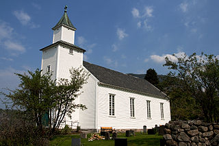
Tau is a village in Strand municipality in Rogaland county, Norway. The village is located on the shore of the Horgefjorden, a branch of the main Boknafjorden. The 2.11-square-kilometre (520-acre) village has a population (2015) of 3,158 which gives the village a population density of 1,497 inhabitants per square kilometre (3,880/sq mi). Strand Church is located in the village.

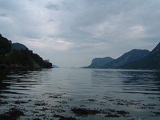
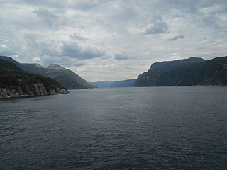
Boknafjord or Boknafjorden is a fjord located in Rogaland county, Norway. The huge fjord lies between the cities Stavanger and Haugesund, and the main part of the fjord is shared between the municipalities of Kvitsøy, Rennesøy, Finnøy, Tysvær, Bokn, and Karmøy. There are dozens of smaller fjords that branch off the main part of the fjord, reaching most municipalities in the county. At its longest, the Boknafjord reaches about 96 kilometres (60 mi) into the mainland at the innermost point of the Hylsfjorden. Other notable branches include the Saudafjorden, Sandsfjorden, Vindafjorden, Hervikfjorden, Førresfjorden, Erfjorden, Jøsenfjorden, Årdalsfjorden, Idsefjorden, Høgsfjorden, Lysefjorden, and Gandsfjorden.

Saudafjord or Saudafjorden is a fjord in Rogaland county, Norway. The fjord stretches from the town of Sauda in the municipality of Sauda in the north to the village of Sand in the municipality of Suldal where the Saudafjorden and Hylsfjorden join together to form the Sandsfjorden.

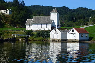
Jelsa is a village in Suldal municipality in Rogaland county, Norway. The village is located along the inner part of the Boknafjorden, near the mouths of the Sandsfjorden and Erfjorden. The village is the site of a school, store, gas station, and some small stores. There was a barrel factory here until it closed in 2009. Jelsa Church is located in this village.

Sand is the administrative centre of the municipality of Suldal in Rogaland county, Norway. The village lies on the shore of the Sandsfjorden at the mouth of the river Suldalslågen, just south of the mouth of the Hylsfjorden. The 1-square-kilometre (250-acre) village has a population (2013) of 1149, giving the village a population density of 1,149 inhabitants per square kilometre (2,980/sq mi).
Høgsfjorden is a fjord in Rogaland county, Norway. The innermost part of the fjord is located at the village of Frafjord in the municipality of Gjesdal. It flows west to Dirdal and then heads northwards. At the village of Forsand, the Lysefjord branches off to the northeast. The Høgsfjorden continues to the northwest past the islands of Idsal and Idse before emptying into the Horgefjorden and ultimately into the vast Boknafjorden. The fjord runs through the municipalities of Gjesdal, Forsand, Sandnes, and Strand.
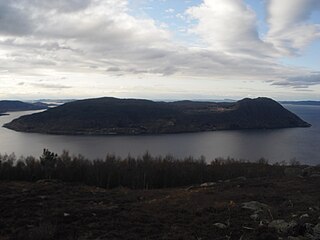
Vestre Bokn is an island in Bokn municipality in Rogaland county, Norway. The 36-square-kilometre (14 sq mi) island is the main island of the municipality. It lies on the northern side of the Boknafjorden at the southern end of the Karmsundet strait. Vestre Bokn lies between the islands of Karmøy and Austre Bokn and Ognøya. The main population centre on the island is the village of Føresvik, the administrative centre of the whole municipality. There are about 661 inhabitants on the island.

Hylsfjorden or Hylsfjord is a fjord in the municipality Suldal in Rogaland county, Norway. The 20-kilometre (12 mi) long fjord runs from the small area of Hylen to the west. It ends just north of the village of Sand where it joins the Saudafjorden and together they form the Sandsfjorden, an inner branch of the Boknafjorden. The 160-megawatt (210,000 hp) Hylen Hydroelectric Power Station is located in the inner end of Hylsfjord. The fjord has relatively little development along its shores, only a few small hamlets, with Vanvik being the largest.

Skjoldafjorden is a fjord in Rogaland county, Norway. The 26-kilometre (16 mi) long fjord is a northern branch of vast Boknafjorden which dominates Rogaland county.
Jøsenfjorden is a fjord in the municipality of Hjelmeland in Rogaland county, Norway. The fjord is a branch off of the main Boknafjorden. The fjord has a length of 24 kilometres (15 mi) and a width between 1 to 2 kilometres. The Norwegian National Road 13 runs along the northern shore of the fjord.

Vindafjorden is a fjord in Rogaland county, Norway. The 30-kilometre (19 mi) long fjord is a northern branch off of the main Boknafjorden. The fjord marks the municipal boundaries between Vindafjord, Suldal, and Tysvær. The fjord initially runs from the very narrow Ropeid isthmus to the west and near the village of Vikadal, the fjord heads to the south before emptying into the Boknafjorden near the village of Nedstrand. There are two smaller fjords which branch off of the Vindafjorden. They are the Sandeidfjorden and the Yrkjefjorden. The deepest part of the fjord reaches about 580 metres (1,900 ft) below sea level, just off the shore from Imsland Church.

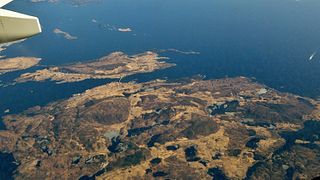
Kvitsøy or Kvitsøya is the main island in Kvitsøy municipality in Rogaland county, Norway. The 2.3-square-kilometre (0.89 sq mi) island is one of 167 islands and skerries that make up the municipality. The island is home to most of the municipal residents, as well as the majority of the municipality's land area. The main population centre on the island is the village of Ydstebøhamn on the southern coast. The Kvitsøy Church and Kvitsøy Lighthouse are both located on the island.

Byfjorden is a fjord in Rogaland county, Norway. The 10-kilometre (6.2 mi) long fjord runs from the Tungenes Lighthouse at the northern end of the Stavanger Peninsula south along the east side of the peninsula to the city of Stavanger. It passes through the municipalities of Randaberg, Rennesøy, and Stavanger. The islands of Bru, Åmøy, Hundvåg, Buøy, Engøy, Sølyst, and Grasholmen lie along the east side of the fjord. The fjord connects to the Boknafjorden at the north end.