The 1,737-square-kilometre (671sqmi) municipality is the 46th largest by area out of the 356 municipalities in Norway. Suldal is the 210th most populous municipality in Norway with a population of 3,815. The municipality's population density is 2.4 inhabitants per square kilometre (6.2/sqmi) and its population has decreased by 1.5% over the previous 10-year period.[4][5]
The parish of Suledal was established as a municipality on 1 January 1838 (see formannskapsdistrikt law). In 1842, the northern district of the municipality (population: 1,584) was separated to become the new municipality of Søvde. This left Suldal with 2,030 residents. During the 1960s, there were many municipal mergers across Norway due to the work of the Schei Committee. On 1 January 1965, Suldal (population: 1,412) was merged with the neighboring municipalities of Sand (population: 1,135) and Erfjord (population: 610) as well as all of the municipality of Jelsa except for the parts on the island of Ombo (population: 928) and the parts of Imsland municipality located south of the Vindafjorden (population: 61). On 1 January 1978, the parts of Vindafjord Municipality located southeast of the Vindafjorden on the Ropeid peninsula (population: 13) was transferred to Suldal.[6]
Name
The municipality (originally the parish) is named after the Suledalen valley (Old Norse: Súladalr) since it was a central geographical feature of the municipality. The first element is the plural genitive case of súla which means "pillar" or "column" (likely referring to the mountain pass Suldalsporten). The last element is dalr which means "valley" or "dale". Before 1891, the name was written "Suledal".[7]
Coat of arms
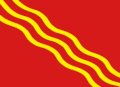
The coat of arms was granted on 11 March 1976. The official blazon is "Gules, three bendlets wavy Or" (Norwegian: I raudt ein gull bølgjeforma trillingstreng, skråstilt høgre venstre). This means the arms have a red field (background) and the charge is a set of the three diagonal wavy lins. The charge has a tincture of Or which means it is commonly colored yellow, but if it is made out of metal, then gold is used. The lines represent the local river Suldalslågen which runs through the municipality. The arms were designed by Magnus Hardeland. The municipal flag has the same design as the coat of arms.[8][9][10]
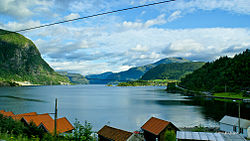
View of rural SuldalView of the Suldal valley (with Sand village at the top)
The area that is now Suldal municipality has a long history of trade connections to the nearby valley regions to the north and east. The main mountain plateau trade route led east from Suldal municipality over the plateau to the nearby Setesdal valley in Bykle municipality in Agder county. Another route led north from Suldal in Rogaland county through the Røldal area in Vestland county, and then east into Vinje municipality in Telemark county. There has also been found Viking artefacts and graves in Suldal.
The Ulla-Førre project of building huge hydroelectric dams in the mountains was initiated in the 1960s. At times, the project employed over a thousand people. The finished hydroelectric complex has a total capacity of approximately 2,100 megawatts (2,800,000hp) and produces about 4.8 terawatt-hours (17PJ) yearly.
The municipal council (Kommunestyre) of Suldal is made up of 19 representatives that are elected to four year terms. The tables below show the current and historical composition of the council by political party.
This page is based on this Wikipedia article Text is available under the CC BY-SA 4.0 license; additional terms may apply. Images, videos and audio are available under their respective licenses.