Sogndal, Rogaland

Last updated
Sogndal ladested
Rekefjord-in-Sogndal.jpg
Postcard from 1910 of Rægefjord in Sogndal
Norway Counties Rogaland Position.svg
NO 1107 Sogndal.svg
Sogndal within Rogaland
Coordinates: 58°19′22″N06°17′04″E / 58.32278°N 6.28444°E / 58.32278; 6.28444
Country Norway
County Rogaland
District Dalane
Established1 Jan 1845
  Preceded by Soggendahl Municipality
Disestablished1 July 1944
  Succeeded by Sokndal Municipality
Administrative centre Sogndalsstranda
Area
 (upon dissolution)
  Total0.19 km2 (0.07 sq mi)
Population
 (1944)
  Total311
  Density1,600/km2 (4,200/sq mi)
Time zone UTC+01:00 (CET)
  Summer (DST) UTC+02:00 (CEST)
ISO 3166 code NO-1107

Sogndal is a former municipality and small seaport ( ladested ) in Rogaland county, Norway. The municipality is located on the coast in the traditional district of Dalane. The 19-hectare (47-acre) municipality existed from 1845 until its dissolution in 1944 when it was merged into the municipality of Sokndal. It comprised the two harbor villages: the 7-hectare (17-acre) Sogndalsstranda and the 12-hectare (30-acre) Rægefjord. The river Sogndalselva reaches the ocean at Songdalsstranda. [1] [2]

Contents

History

The seaport village of Sogndalsstranda was built up around the Kjelland farm (historically spelled Kielland). The farm (named after a spring (kilde) situated there) was owned by the Kielland family, from which Alexander Kielland descended. This family left Sogndal in 1751 and established a successful firm in Stavanger. The Kielland farm can still be found there. [3] As is typical of older records, this farm is listed in historical records under a number of phonetically similar names: Kollandt in 1563, Kieldeland in 1567, Kuelandt in 1567, Tielland in 1610, Kielland in 1616, Kiedland in 1668 and finally fixing on Kielland since 1723. [4]

The villages of Sogndalsstranda and Rægestad are located near each other and together they were granted ladested rights in 1798. Together, this ladested was called Sogndal (historically spelled "Soggendahl"). This status gave them a monopoly on import and export of goods and materials in the port and in the surrounding district. [5]

On 1 January 1838, all of Norway was divided up into municipalities according to the formannskapsdistrikt law. The ladested of Sogndal was put into the municipality of Sokndal. In 1845, the ladested of Sogndal was separated from Sokndal and became a municipality of its own. Initially, Sogndal ladested had a population of 348 while the rural Sokndal municipality that surrounded it had a population of 2,819. In 1875, the population of Sogndal had grown to 526, but decreased to 473 in 1885. On 1 July 1944, Sogndal was merged back together with Sokndal municipality, losing its small seaport status. Prior to the merger, Sogndal had a population of 311. [6]

Name

The municipality (originally the parish) is named after the Soknedalen valley (Old Norse : Sóknardalr) since the first Sokndal Church was built there. The first element is the genitive case of the river name Sókn (now Sokno). That river name is derived from the verb sœkja which means "to seek" or "to strive for". The last element is dalr which means "valley" or "dale". Thus, the meaning is "the valley with the river which seeks (finds/forces) its way". Before 1918, the name was written "Sogndal" or "Soggendahl". This municipality was a ladested called Sogndal ladested, but it was surrounded by a rural municipality with the same name called Sogndal herred. [7]

Government

While it existed, this municipality was responsible for primary education (through 10th grade), outpatient health services, senior citizen services, unemployment, social services, zoning, economic development, and municipal roads. During its existence, this municipality was governed by a municipal council of directly elected representatives. The mayor was indirectly elected by a vote of the municipal council. [8]

Municipal council

The municipal council (Bystyre) of Sogndal was made up of 12 representatives that were elected to three-year terms. The party breakdown of the final municipal council was as follows:

Sogndal bystyre 19381941* [9]   
Party Name (in Norwegian)Number of
representatives
  Local List(s) (Lokale lister)12
Total number of members:12
Note: Due to the German occupation of Norway during World War II, no elections were held for new municipal councils until after the war ended in 1945.
Sogndal bystyre 19351937 [10]   
Party Name (in Norwegian)Number of
representatives
  Local List(s) (Lokale lister)12
Total number of members:12
Sogndal bystyre 19321934 [11]   
Party Name (in Norwegian)Number of
representatives
  Local List(s) (Lokale lister)12
Total number of members:12
Sogndal bystyre 19291931 [12]   
Party Name (in Norwegian)Number of
representatives
  Local List(s) (Lokale lister)12
Total number of members:12
Sogndal bystyre 19261928 [13]   
Party Name (in Norwegian)Number of
representatives
  Local List(s) (Lokale lister)12
Total number of members:12
Sogndal bystyre 19231925 [14]   
Party Name (in Norwegian)Number of
representatives
  Local List(s) (Lokale lister)12
Total number of members:12
Sogndal bystyre 19201922 [15]   
Party Name (in Norwegian)Number of
representatives
  Local List(s) (Lokale lister)12
Total number of members:12

See also

Related Research Articles

<span class="mw-page-title-main">Sokndal</span> Municipality in Rogaland, Norway

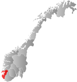
Sokndal is the southernmost municipality in Rogaland county, Norway. It is located in the traditional district of Dalane. The administrative centre of the municipality is the village of Hauge. Other villages in Sokndal include Li, Rekefjord, Sogndalsstranda, and Åna-Sira.

<span class="mw-page-title-main">Lund, Norway</span> Municipality in Rogaland, Norway

Lund is a municipality in Rogaland county, Norway. It is located in the traditional district of Dalane. The administrative centre of the municipality is the village of Moi. Other villages in Lund include Eik and, Heskestad. European route E39 and the Sørlandet Line both pass through Lund. Moi Station is a railway station in Lund.

<span class="mw-page-title-main">Kopervik</span> Town in Rogaland, Norway

Kopervik is the largest town on the island of Karmøy in Rogaland county, Norway. It is also the administrative centre of the municipality of Karmøy. It is part of the traditional district of Haugaland. The town was also an independent municipality from 1866 until 1965.

<span class="mw-page-title-main">Skudeneshavn</span> Town in Rogaland, Norway

is a town in Karmøy municipality in Rogaland county, Norway. It is located on the southernmost tip of the island of Karmøy at the entrance to the Boknafjorden and Karmsundet strait. The town is part of the traditional district of Haugaland. The town was an independent municipality due to its status as a ladested from 1858 until 1965.

<span class="mw-page-title-main">Stathelle</span> Town in Bamble, Norway

is a town in Bamble Municipality in Vestfold og Telemark county, Norway. The town is located at the confluence of the Frierfjorden, Eidangerfjord, and Langesundsfjorden. The town of Brevik lies about 1 kilometre (0.62 mi) across the fjord and the town of Langesund lies about 4 kilometres (2.5 mi) to the southeast. Stathelle Church is located in the town.

<span class="mw-page-title-main">Brevik, Norway</span> Town in Telemark county, Norway

Brevik is a town in Porsgrunn Municipality in Vestfold og Telemark county, Norway. The town is located where the Eidangerfjorden and Frierfjorden join together to form the Breviksfjorden. Brevik is regarded as one of the best preserved towns from the sailing ship era. The town is located on the far end of Eidanger peninsula, and was a former export centre for ice and timber. The last shipment of wood to the United Kingdom was around 1960.

<span class="mw-page-title-main">Skudenes</span> Former municipality in Rogaland, Norway

Skudenes is a former municipality in Rogaland county, Norway. It was part of the traditional district of Haugaland. The 68-square-kilometre (26 sq mi) municipality existed from 1838 until its dissolution in 1965. The administrative centre was the town of Skudeneshavn. The municipality originally encompassed land that is now part of the municipalities of Bokn and Karmøy. It included the southern part of the island of Karmøy and the three islands to the east: Vestre Bokn, Austre Bokn, and Ognøya. In 1849, the three smaller islands were separated to form Bokn municipality.

<span class="mw-page-title-main">Vestre Moland</span> Former municipality in Aust-Agder, Norway

Vestre Moland is a former municipality in the old Aust-Agder county in Norway. The administrative centre of the municipality was the village of Møglestu where the Vestre Moland Church is located. The 103-square-kilometre (40 sq mi) municipality existed from 1838 until 1962 when it was merged into the municipality of Lillesand. Today, the area of Vestre Moland covers the northern part of the present-day municipality of Lillesand in Agder county.

<span class="mw-page-title-main">Stangaland</span> Former municipality in Rogaland, Norway

Stangaland is a former municipality in Rogaland county, Norway. It was part of the traditional district of Haugaland. The municipality of Stangaland existed from 1909 until 1965 when it was merged into the newly created Karmøy Municipality. The 28-square-kilometre (11 sq mi) municipality encompassed the rural areas surrounding the coastal city of Kopervik on the island of Karmøy. The administrative centre was the village of Stangaland just outside the town of Kopervik.

<span class="mw-page-title-main">Torvastad</span> Former municipality in Rogaland, Norway

Torvastad is a former municipality in Rogaland county, Norway. The municipality existed from 1838 until 1965. The administrative centre was the village of Haugesund, and after that it was the village of Torvastad on the island of Karmøy. Today, the area of Torvastad refers to the northern part of the municipality of Karmøy.

<span class="mw-page-title-main">Høyland</span> Former municipality in Rogaland, Norway

Høyland is a former municipality in Rogaland county, Norway. The 170-square-kilometre (66 sq mi) municipality was located at the innermost end of the Gandsfjorden in the western part of the present-day municipality of Sandnes. The municipality existed from 1838 until its dissolution in 1965. The main church for the municipality was Høyland Church.

<span class="mw-page-title-main">Rekefjord</span> Village in Western Norway, Norway

Rekefjord is a harbour village in the municipality of Sokndal in Rogaland county, Norway. The village is located around the Rekefjorden, about 1 kilometre (0.62 mi) west of the municipal centre of Hauge i Dalane. The village of Sogndalsstranda lies about 2 kilometres (1.2 mi) southeast of Rekefjord.

<span class="mw-page-title-main">Jelsa (municipality)</span> Former municipality in Rogaland, Norway

Jelsa is a former municipality in Rogaland county, Norway. The 130-square-kilometre (50 sq mi) municipality existed from 1838 until 1965. It encompassed area that surrounds the Sandsfjorden in the present-day municipalities of Suldal, Hjelmeland, and Stavanger. The administrative centre was the village of Jelsa, where Jelsa Church is located.

<span class="mw-page-title-main">Vikedal (municipality)</span> Former municipality in Rogaland, Norway

Vikedal is a former municipality in Rogaland county, Norway. The 134-square-kilometre (52 sq mi) municipality existed from 1838 until its dissolution in 1965. It was located along the Vindafjorden and Sandeidfjorden in the northern part of the Ryfylke district. The administrative centre of the municipality was the village of Vikedal, where Vikedal Church is located.

<span class="mw-page-title-main">Skjold (municipality)</span> Former municipality in Rogaland, Norway

Skjold is a former municipality in Rogaland county, Norway. The 172-square-kilometre (66 sq mi) municipality encompassed all the area surrounding the Grindafjorden and Skjoldafjorden. The area is located in the present-day municipalities of Vindafjord and Tysvær. The administrative centre of the municipality was the village of Skjold where the Skjold Church is located.

<span class="mw-page-title-main">Vats (municipality)</span> Former municipality in Rogaland, Norway

Vats is a former municipality in Rogaland county, Norway. Located in the traditional district of Haugaland, the municipality existed from 1891 until 1965. The 124-square-kilometre (48 sq mi) municipality encompassed the land to the east and west surrounding the Vatsfjorden and the lake Vatsvatnet. Vats is typically divided into two parts Øvre Vats and Nedre Vats.

<span class="mw-page-title-main">Nedstrand (municipality)</span> Former municipality in Rogaland, Norway

Nedstrand is a former municipality in Rogaland county, Norway. The 119-square-kilometre (46 sq mi) municipality was located along the Nedstrandfjorden, an inner branch off the main Boknafjorden. The municipality encompassed the majority of the Nedstrand peninsula. Originally it also included the Sjernarøyane islands and the western part of the island of Ombo in the fjord to the south. The administrative centre of the municipality was the village of Nedstrand. Nedstrand Church is located in Hindaråvåg, a small village just west of Nedstrand village. Today, the area is part of the large municipality of Tysvær.

<span class="mw-page-title-main">Madla (municipality)</span> Former municipality in Rogaland, Norway

Madla is a former municipality in Rogaland county, Norway. The 15.75-square-kilometre (6.08 sq mi) municipality existed from 1930 until 1965 when it was merged into Stavanger Municipality. The small municipality now exists as the borough of Madla inside the city of Stavanger, on the northeast side of the Hafrsfjorden. It was one of the smallest municipalities in Rogaland county, with only four farms: Malde, Revheim, and North- and South-Sunde. The municipal centre was located at Malde, now known as Madlamark.

<span class="mw-page-title-main">Nærbø (municipality)</span> Former municipality in Rogaland, Norway

Nærbø is a former municipality in Rogaland county, Norway. The administrative centre of the municipality was the village of Nærbø where the Old Nærbø Church is located. The 65-square-kilometre (25 sq mi) municipality was located in the district of Jæren inside the northern part of the present-day municipality of Hå. The municipality existed from 1894 until its dissolution in 1964.

<span class="mw-page-title-main">Varhaug (municipality)</span> Former municipality in Rogaland, Norway

Varhaug is a former municipality in Rogaland county, Norway. The 85-square-kilometre (33 sq mi) municipality existed from 1894 until 1964. The administrative centre of the municipality was the village of Varhaug where Varhaug Church is located. The municipality encompassed the central part of the present-day Hå Municipality. It included the villages of Varhaug and Vigrestad as well as the surrounding countryside.

References

  1. Store norske leksikon. "Sogndal – ladested" (in Norwegian). Retrieved 6 July 2016.
  2. Helland, Amund (1888). "Sogndal by". XI Stavanger amt. Norges land og folk (in Norwegian). Kristiania, Norway: H. Aschehoug & Company. p. 92. Retrieved 3 July 2022.
  3. Stagg, Frank Noel (1958). South Norway . George Allen & Unwin, Ltd.
  4. Kielland, Gabriel Wilhelm (29 August 2002). "Opprinnelsen" (in Norwegian).
  5. Brandsberg, Reidar (1988). Sogndal Ladested, Sokndal og Eigersund - i eldre og nyere tid (in Norwegian). Egersund: Fuglseth bok- og offsettrykkeri. ISBN   9788299181303.
  6. Jukvam, Dag (1999). Historisk oversikt over endringer i kommune- og fylkesinndelingen (PDF) (in Norwegian). Statistisk sentralbyrå. ISBN   9788253746845.
  7. Rygh, Oluf (1915). Norske gaardn avne: Stavanger amt (in Norwegian) (10 ed.). Kristiania, Norge: W. C. Fabritius & sønners bogtrikkeri. p. 1.
  8. Hansen, Tore; Vabo, Signy Irene, eds. (20 September 2022). "kommunestyre". Store norske leksikon (in Norwegian). Kunnskapsforlaget . Retrieved 1 January 2023.
  9. "Kommunevalgene og Ordførervalgene 1937" (PDF) (in Norwegian). Oslo: Statistisk sentralbyrå. 1938. Retrieved 14 July 2020.
  10. "Kommunevalgene og Ordførervalgene 1934" (PDF) (in Norwegian). Oslo: Statistisk sentralbyrå. 1935. Retrieved 31 July 2020.
  11. "Kommunevalgene og Ordførervalgene 1931" (PDF) (in Norwegian). Oslo: Statistisk sentralbyrå. 1932. Retrieved 31 July 2020.
  12. "Kommunevalgene og Ordførervalgene 1928" (PDF) (in Norwegian). Oslo: Statistisk sentralbyrå. 1929. Retrieved 31 July 2020.
  13. "Kommunevalgene og Ordførervalgene 1925" (PDF) (in Norwegian). Oslo: Statistisk sentralbyrå. 1926. Retrieved 31 July 2020.
  14. "Kommunevalgene og Ordførervalgene 1922" (PDF) (in Norwegian). Oslo: Statistisk sentralbyrå. 1923. Retrieved 31 July 2020.
  15. "Kommunevalgene og Ordførervalgene 1919" (PDF) (in Norwegian). Oslo: Statistisk sentralbyrå. 1920. Retrieved 31 July 2020.