
Eigersund is a municipality in Rogaland county, Norway. It is in the traditional district of Dalane. The administrative centre of the municipality is the town of Egersund. The town was known for its pottery factory and it is among Norway's biggest fishing ports. The villages of Helleland, Hellvik, and Hestnes are also in Eigersund.

Sandnes (help·info) is a city and municipality in Rogaland county, Norway. It is the 8th largest city in Norway and it lies immediately south of the city of Stavanger, the 4th largest city in Norway. Together, the Stavanger/Sandnes area is the 3rd largest urban area in Norway.

Lund is a municipality in Rogaland county, Norway. It is located in the traditional district of Dalane. The administrative centre of the municipality is the village of Moi. Other villages in Lund include Eik, Heskestad, and Åna-Sira. European route E39 and the Sørlandet Line both pass through Lund. Moi Station is a railway station in Lund.

Leikanger is a municipality in Sogn og Fjordane county, Norway. It is located on the northern shore of the Sognefjorden in the traditional district of Sogn. The administrative center is the village of Hermansverk, which is also the administrative center of Sogn og Fjordane county.
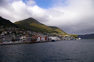
Egersund is a town in Eigersund municipality in Rogaland county, Norway. The town is located along the southwestern coast of Norway, about 75 kilometres (47 mi) south of the city of Stavanger. The town is situated along a strait which separates the mainland from the island of Eigerøya. The 6.36-square-kilometre (1,570-acre) village has a population (2015) of 11,473 which gives the town a population density of 1,804 inhabitants per square kilometre (4,670/sq mi).

Mosjøen or Mussere (Southern Sami) is a town in Vefsn Municipality in Nordland county, Norway. Mosjøen is the oldest town in the Helgeland region, with only the town of Bodø being older within Nordland county. The town is also the administrative centre of Vefsn Municipality. The old village of Mosjøen was declared a ladested in 1875. It was also a town municipality from 1875 until 1961 when it was merged into Vefsn, losing its status as a town (ladested). It is also a former garrison town and customs place. In 1998, the urban area of Mosjøen was declared to be a town once again. People from Mosjøen are referred to using the demonym "mosjøværing". The 6.36-square-kilometre (1,570-acre) town has a population (2018) of 9,834 and a population density of 1,528 inhabitants per square kilometre (3,960/sq mi).
Måløy is a town and the administrative centre of the municipality of Vågsøy in Sogn og Fjordane county, Norway. Måløy is located on the southeastern side of the island of Vågsøy, about 3 kilometres (1.9 mi) northeast of the village of Holvika and about 6 kilometres (3.7 mi) south of the village of Raudeberg. The Måløy Bridge connects the town centre to the area of Deknepollen on the mainland. Sør-Vågsøy Church is located in Måløy.

Kopervik is the largest town on the island of Karmøy in Rogaland county, Norway. It is also the administrative centre of the municipality of Karmøy. It is part of the traditional district of Haugaland. The 4.85-square-kilometre (1,200-acre) town has a population (2017) of 11,250; giving the town a population density of 1,694 inhabitants per square kilometre (4,390/sq mi). The municipality of Karmøy has about 42,000 inhabitants, so this means Kopervik is home to about 20% of the municipal population.

Skudeneshavn (help·info) is a town in Karmøy municipality in Rogaland county, Norway. It is located on the southernmost tip of the island of Karmøy at the entrance to the Boknafjorden and Karmsundet strait. The town is part of the traditional district of Haugaland.

Åkrehamn (help·info) or Åkrahamn is a small town in Karmøy municipality in Rogaland county, Norway. The town is located on the west side of the island of Karmøy in the traditional district of Haugaland. The town sits about 5 kilometres (3.1 mi) west of the town of Kopervik, about 12 kilometres (7.5 mi) north of the town of Skudeneshavn, and about 25 kilometres (16 mi) southwest of the town of Haugesund. The village of Veavågen lies immediately to the northeast of Åkrehamn.

Hauge or Hauge i Dalane is the administrative center of Sokndal municipality in Rogaland county, Norway. It is located along the river Sokno, between the coastal villages of Rekefjord and Sogndalsstranda. Sokndal Church is located in the village.
Eiavatnet is a lake in the municipalities of Eigersund and Sokndal in Rogaland county, Norway. The 4.29-square-kilometre (1.66 sq mi) lake is located about 15 kilometres (9.3 mi) east of the town of Egersund. The lake is regulated at an elevation of 139 metres (456 ft) so it can be used as a reservoir for the Lindland Power Station which is located a short distance north of Hauge in Sokndal. The lake Grøsfjellvatnet lies about 1 kilometre (0.62 mi) north of this lake.
Grøsfjellvatnet is a lake in the municipalities of Eigersund, Lund, and Sokndal in Rogaland county, Norway. The 3.09-square-kilometre (1.19 sq mi) lake list just north of the lake Eiavatnet, about 4 kilometres (2.5 mi) west of the village of Heskestad in Lund municipality.

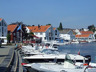
Sogndalsstranda or Sogndalstrand is a harbor village in Sokndal municipality in Rogaland county, Norway. The village is located at the mouth of the river Sokno, about 2 kilometres (1.2 mi) south of the municipal centre of Hauge and also about 2 kilometres (1.2 mi) southeast of the village of Rekefjord. The Jøssingfjorden lies about 2.7 kilometres (1.7 mi) southeast of the village.
Sogndal, Sokndal, or Soknedal are similarly sounding Norwegian place names. They may refer to:
Lillesand is the administrative centre of Lillesand municipality in Aust-Agder county, Norway. The town is located along the Skaggerak coast, about 18 kilometres (11 mi) southwest of the town of Grimstad and about 25 kilometres (16 mi) northeast of the city of Kristiansand. The 5.03-square-kilometre (1,240-acre) town has a population (2016) of 7,530 which gives the town a population density of 1,497 inhabitants per square kilometre (3,880/sq mi).
Vemundvik is a former municipality in the old Nord-Trøndelag county, Norway. The 247-square-kilometre (95 sq mi) municipality existed from 1838 until its dissolution in 1964. By 1964, the municipality roughly corresponded to the mainland areas north of the river Namsen in what is now the municipality of Namsos in Trøndelag county. From 1838 until about 1942, the administrative centre was the village of Vemundvik where Vemundvik Church is located. After 1941, the municipal offices and administration was headquartered in the town of Namsos.


