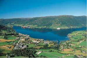
Ølen is a former municipality in the Vestlandet region of Norway. The municipality existed from 1916 until 2006, and originally it was a part of Hordaland county, but in 2002 it was transferred to Rogaland county prior to its dissolution in 2006. The 181-square-kilometre (70 sq mi) municipality was located on the south side of the Bjoafjorden and east of the Ålfjorden. The administrative center of Ølen was the village of Ølensjøen. The municipality of Ølen makes up the northern part of the present-day Vindafjord Municipality in Rogaland county.

Suldal is a municipality in the northeast corner of Rogaland county, Norway. It is located in the traditional district of Ryfylke. Since 1965, the administrative centre of Suldal is the village of Sand i Ryfylke. Other villages in Suldal include Haugsland, Jelsa, Marvik, Nesflaten, and Suldalsosen.

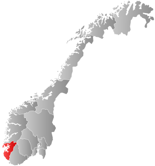
Tysvær is a municipality in Rogaland county, Norway. It is part of the Haugalandet region. The municipality is located on the Haugalandet peninsula on the northern side of the Boknafjorden, just east of the towns of Kopervik and Haugesund. The administrative centre of the municipality is the village of Aksdal. Other villages in the municipality include Dueland, Førre, Grinde, Hervik, Hindaråvåg, Nedstrand, Skjoldastraumen, Susort, Tysvær, and Yrke.
Vindafjord is a municipality in Rogaland county, Norway. It is part of the traditional district of Haugaland. Since 2005, the administrative centre of the municipality has been the village of Ølensjøen. Other villages in the municipality include Bjoa, Imslandsjøen, Ølensvåg, Skjold, Vats, Vikebygd, and Vikedal. The municipality is centered on the Vindafjorden and Sandeidfjorden in the east and it lies north and east of the Skjoldafjorden in the west.

Erfjord is a former municipality in Rogaland county, Norway. The 132-square-kilometre (51 sq mi) municipality existed from 1914 until 1965. It encompassed the area around the Erfjorden in the southwestern part of the present-day municipality of Suldal. The administrative centre of the municipality was the village of Hålandsosen, where the Erfjord Church is located.

Nordli is a former municipality in the old Nord-Trøndelag county in Norway. The 1,527-square-kilometre (590 sq mi) municipality existed from 1915 until its dissolution in 1964. Nordli encompassed the northern part of what is now the municipality of Lierne in Trøndelag county. The administrative centre for the municipality was the village of Sandvika where the Nordli Church is located.
Kvam is a former municipality in what was Nord-Trøndelag county in Norway. The 377-square-kilometre (146 sq mi) municipality existed from 1909 until its dissolution in 1964. The municipality encompassed the areas north and west of the lake Snåsavatnet in what is now the municipality of Steinkjer in Trøndelag county. The administrative centre was the village of Kvam on the shore of the lake. Most of the population of Kvam municipality lived along the lake shore. Farther north from the lake includes a wilderness area including the large lakes Gilten and Bangsjøene. The main church for the municipality was Kvam Church, located in the village of Kvam.

Voll is a former municipality in Møre og Romsdal county, Norway. It existed from 1874 until its dissolution in 1964. The 260-square-kilometre (100 sq mi) municipality encompassed the Måndalen and Innfjorden valleys west of the Romsdalsfjorden in the west-central part of the present-day Rauma Municipality. The administrative centre of the village was the village of Måndalen which is also where the main Voll Church is located.
Eid is a former municipality in Møre og Romsdal county, Norway. The 36-square-kilometre (14 sq mi) municipality existed from 1874 until its dissolution in 1964. It was located along the Romsdalsfjorden in the north-central part of the present-day Rauma Municipality. The administrative centre and largest population centre was the village of Eidsbygda. The municipality then extended to the southeast to the coast of the Isfjorden.

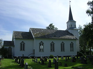
Vikebygd is a former municipality in the old Hordaland county, Norway. The municipality existed from 1902 until its dissolution in 1964. It was located along the eastern and western shores of the Ålfjorden, a small branch off the main Hardangerfjorden. The 102-square-kilometre (39 sq mi) municipality is located in the present-day municipalities of Sveio and in Vindafjord. The administrative centre of the municipality was the village of Vikebygd, where Vikebygd Church is located.

Røldal is a former municipality in the southeastern corner of the old Hordaland county, Norway. The 719-square-kilometre (278 sq mi) municipality existed from 1838 until 1964 and it was located in the southeastern part of the present-day Ullensvang Municipality. The administrative centre was the village of Røldal, where the Røldal Stave Church is located. The municipality encompassed the Røldalen valley and some small side valleys, as well as a large area up on the vast Hardangervidda plateau. Historically, Røldal was an important trade and transportation route between Eastern and Western Norway.
Jelsa is a former municipality in Rogaland county, Norway. The 130-square-kilometre (50 sq mi) municipality existed from 1838 until 1965. It encompassed area that surrounds the Sandsfjorden in the present-day municipalities of Suldal, Hjelmeland, and Stavanger. The administrative centre was the village of Jelsa, where Jelsa Church is located.

Sand is a former municipality in Rogaland county, Norway. The 221-square-kilometre (85 sq mi) municipality encompassed the area around the Hylsfjorden and the inner part of the Sandsfjorden in the present-day Suldal Municipality. The administrative centre of the municipality was the village of Sand where Sand Church is located.

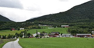
Vikedal is a former municipality in Rogaland county, Norway. The 134-square-kilometre (52 sq mi) municipality existed from 1838 until its dissolution in 1965. It was located along the Vindafjorden and Sandeidfjorden in the northern part of the Ryfylke district. The administrative centre of the municipality was the village of Vikedal, where Vikedal Church is located.

Skjold is a former municipality in Rogaland county, Norway. The 172-square-kilometre (66 sq mi) municipality encompassed all the area surrounding the Grindafjorden and Skjoldafjorden. The area is located in the present-day municipalities of Vindafjord and Tysvær. The administrative centre of the municipality was the village of Skjold where the Skjold Church is located.

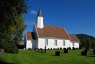
Sandeid is a former municipality in Rogaland county, Norway. The 66-square-kilometre (25 sq mi) municipality existed from 1923 until its dissolution in 1965. It was located at the northern end of the Sandeidfjorden in what is now part of the municipality of Vindafjord. The administrative centre of the municipality was the village of Sandeid where Sandeid Church is located.

Vats is a former municipality in Rogaland county, Norway. Located in the traditional district of Haugaland, the municipality existed from 1891 until 1965. The 124-square-kilometre (48 sq mi) municipality encompassed the land to the east and west surrounding the Vatsfjorden and the lake Vatsvatnet. Vats is typically divided into two parts Øvre Vats and Nedre Vats.
Nedstrand is a former municipality in Rogaland county, Norway. The 119-square-kilometre (46 sq mi) municipality was located along the Nedstrandfjorden, an inner branch off the main Boknafjorden. The municipality encompassed the majority of the Nedstrand peninsula. Originally it also included the Sjernarøyane islands and the western part of the island of Ombo in the fjord to the south. The administrative centre of the municipality was the village of Nedstrand. Nedstrand Church is located in Hindaråvåg, a small village just west of Nedstrand village. Today, the area is part of the large municipality of Tysvær.

Madla is a former municipality in Rogaland county, Norway. The 15.75-square-kilometre (6.08 sq mi) municipality existed from 1930 until 1965 when it was merged into Stavanger Municipality. The small municipality now exists as the borough of Madla inside the city of Stavanger, on the northeast side of the Hafrsfjorden. It was one of the smallest municipalities in Rogaland county, with only four farms: Malde, Revheim, and North- and South-Sunde. The municipal centre was located at Malde, now known as Madlamark.

Stemshaug is a former municipality in Møre og Romsdal county, Norway. The 157-square-kilometre (61 sq mi) municipality existed from 1914 until its dissolution in 1965. The municipality included the eastern part of the island of Skardsøya and the mainland to the east and south of there surrounding the Dromnessundet and Torsetsundet straits and the Årvågsfjorden. The Tjeldbergodden area on the mainland was also part of Stemshaug. The village of Stemshaug was the administrative centre of the municipality.


