Hetland

Last updated
Hetland kommune
Grodem on Randaberg.JPG
View of Grødem village
Norway Counties Rogaland Position.svg
NO 1126 Hetland.svg
Hetland within Rogaland
Coordinates: 58°53′32″N05°44′01″E / 58.89222°N 5.73361°E / 58.89222; 5.73361
Country Norway
County Rogaland
District Jæren
Established1 Jan 1838
  Created as Formannskapsdistrikt
Disestablished1 Jan 1965
  Succeeded by Sandnes and Stavanger municipalities
Area
 (upon dissolution)
  Total92 km2 (36 sq mi)
Population
 (1965)
  Total24,173
  Density260/km2 (680/sq mi)
Demonym Hetlandsbu [1]
Time zone UTC+01:00 (CET)
  Summer (DST) UTC+02:00 (CEST)
ISO 3166 code NO-1126

Hetland is a former municipality in Rogaland county, Norway. The municipality existed from 1838 until 1965 when it was dissolved. The municipality included the Stavanger Peninsula and the land surrounding both sides of the Gandsfjorden, but not the area around the head of the fjord. It originally encompassed the land surrounding the city of Stavanger in the present-day municipalities of Randaberg and Stavanger (except the city of Stavanger) and part of the municipality of Sandnes. The main church for Hetland was Hetland Church (now named "Frue Church"). Upon its dissolution in 1965, the 92-square-kilometre (36 sq mi) municipality had 24,173 residents. [2]

Contents

History

1855 map of the city of Stavanger. The municipality of Hetland surrounds the city, with Hetland Church located just outside the city. Stavanger amt nr 5- Kart over Stavanger og naermeste Omegn, 1855.jpg
1855 map of the city of Stavanger. The municipality of Hetland surrounds the city, with Hetland Church located just outside the city.

The parish of Hetland was established as a municipality on 1 January 1838 (see formannskapsdistrikt law). On 1 July 1922, the northwestern district of the municipality (population: 1,256) was separated to form the new municipality of Randaberg. This split left Hetland with 10,167 residents. The port city of Stavanger was located along the Gandsfjorden, adjacent to Hetland and as the city expanded over the years, areas of Hetland were annexed to join the city. Such changes happened in 1867, 1879, 1906, 1923, and 1953. Also on 1 January 1912, a small area in Høyland municipality (population: 41) was transferred to Hetland. [3]

On 1 January 1965, there were many major municipal changes in Norway due to the work of the Schei Committee. On that date, Hetland municipality was dissolved and its lands were transferred to its neighbors. The parts of Hetland located east of the Gandsfjorden, namely the districts of Riska and Dale (population: 2,077) were merged into a much larger Sandnes municipality. The rest of Hetland, located on the west side of the fjord (population: 20,861) was merged into the municipality of Stavanger, greatly expanding its size. [3]

Name

The municipality (originally the parish) is named after the old Hetland farm (Old Norse : Hesliland) since the first Hetland Church was built there. The first element is hesli which means "hazel tree". The last element is land which means "land" or "district". [4]

Government

While it existed, this municipality was responsible for primary education (through 10th grade), outpatient health services, senior citizen services, unemployment, social services, zoning, economic development, and municipal roads. During its existence, this municipality was governed by a municipal council of directly elected representatives. The mayor was indirectly elected by a vote of the municipal council. [5]

Mayors

The mayors (Norwegian : ordfører) of Hetland: [6]

  • 1838-1841: Ommund Larsen Stokke
  • 1841-1841: Samuel Samuelsen Ledaal
  • 1842-1845: Halvor Sondresen
  • 1843-1843: Sven Knutsen Bø
  • 1846-1849: Jakob Christian Lindemann Bull
  • 1850-1857: Asser E. Jaatten
  • 1858-1858: Niels Qvaleberg
  • 1858-1860: Wilhelm Ravn Sundt
  • 1861-1861: Johan E. Nymann
  • 1862-1863: Halvor B. Scheie
  • 1864–1867: Olaus Olsen Eskeland (V)
  • 1868-1869: Gullik Furta Gitlesen
  • 1870–1890: Olaus Olsen Eskeland (V)
  • 1890-1891: Erik A. Gilje
  • 1892-1893: Thore Olsen Wølstad
  • 1894–1903: Olaus Olsen Eskeland (V)
  • 1903-1904: Arne Berge
  • 1905-1912: Thore Olsen Wølstad
  • 1912-1913: Osmund Rossavik
  • 1914-1916: Karl L. Helliesen
  • 1917-1922: Christian Eriksen Gilje
  • 1923-1925: Henrik O. Tjensvold
  • 1926-1941: Olav Tveterås (V)
  • 1941-1945: Peter Gustav Adolf Thjømøe (NS)
  • 1945–1959: Johan Askeland (V)
  • 1960-1965: Per Barkved (V)

Municipal council

The municipal council (Herredsstyre) of Hetland was made up of representatives that were elected to four year terms. The party breakdown of the final municipal council was as follows:

Hetland herredsstyre 19641965 [7]   
Party Name (in Norwegian)Number of
representatives
  Labour Party (Arbeiderpartiet)17
  Conservative Party (Høyre)10
  Christian Democratic Party (Kristelig Folkeparti)4
  Centre Party (Senterpartiet)2
  Liberal Party (Venstre)8
Total number of members:41
Hetland herredsstyre 19601963 [8]   
Party Name (in Norwegian)Number of
representatives
  Labour Party (Arbeiderpartiet)16
  Conservative Party (Høyre)8
  Christian Democratic Party (Kristelig Folkeparti)5
  Centre Party (Senterpartiet)2
  Liberal Party (Venstre)10
Total number of members:41
Hetland herredsstyre 19561959 [9]   
Party Name (in Norwegian)Number of
representatives
  Labour Party (Arbeiderpartiet)16
  Conservative Party (Høyre)6
  Christian Democratic Party (Kristelig Folkeparti)4
  Farmers' Party (Bondepartiet)2
  Liberal Party (Venstre)10
  Joint List(s) of Non-Socialist Parties (Borgerlige Felleslister)3
Total number of members:41
Hetland herredsstyre 19521955 [10]   
Party Name (in Norwegian)Number of
representatives
  Labour Party (Arbeiderpartiet)15
  Conservative Party (Høyre)5
  Christian Democratic Party (Kristelig Folkeparti)4
  Farmers' Party (Bondepartiet)2
  Liberal Party (Venstre)11
  Joint List(s) of Non-Socialist Parties (Borgerlige Felleslister)2
  Local List(s) (Lokale lister)1
Total number of members:40
Hetland herredsstyre 19481951 [11]   
Party Name (in Norwegian)Number of
representatives
  Labour Party (Arbeiderpartiet)8
  Conservative Party (Høyre)4
  Communist Party (Kommunistiske Parti)2
  Christian Democratic Party (Kristelig Folkeparti)2
  Farmers' Party (Bondepartiet)2
  Liberal Party (Venstre)9
  List of workers, fishermen, and small farmholders (Arbeidere, fiskere, småbrukere liste)1
  Joint List(s) of Non-Socialist Parties (Borgerlige Felleslister)4
Total number of members:32
Hetland herredsstyre 19451947 [12]   
Party Name (in Norwegian)Number of
representatives
  Labour Party (Arbeiderpartiet)10
  Conservative Party (Høyre)3
  Communist Party (Kommunistiske Parti)2
  Christian Democratic Party (Kristelig Folkeparti)2
  Farmers' Party (Bondepartiet)2
  Liberal Party (Venstre)7
  List of workers, fishermen, and small farmholders (Arbeidere, fiskere, småbrukere liste)3
  Local List(s) (Lokale lister)3
Total number of members:32
Hetland herredsstyre 19381941* [13]   
Party Name (in Norwegian)Number of
representatives
  Labour Party (Arbeiderpartiet)9
  Conservative Party (Høyre)4
  Farmers' Party (Bondepartiet)3
  Liberal Party (Venstre)10
  Joint List(s) of Non-Socialist Parties (Borgerlige Felleslister)3
  Local List(s) (Lokale lister)3
Total number of members:32
Note: Due to the German occupation of Norway during World War II, no elections were held for new municipal councils until after the war ended in 1945.

See also

Related Research Articles

<span class="mw-page-title-main">Sandnes</span> Municipality in Rogaland County, Norway

Sandnes is a city and municipality in Rogaland, Norway. It lies immediately south of Stavanger, the 4th largest city in Norway, and together the Stavanger/Sandnes area is the third-largest urban area in Norway. The urban city of Sandnes lies in the extreme western part of the vast municipality and it makes up about 5% of the total land area of the municipality.

<span class="mw-page-title-main">Klepp</span> Municipality in Rogaland, Norway

Klepp is a municipality in Rogaland county, Norway. It is located in the traditional district of Jæren. The administrative centre of the municipality is the village of Kleppe. Other villages in Klepp include Klepp stasjon, Orre, Orstad, Pollestad, Verdalen, and Voll. Klepp is a flat and open agricultural landscape. The highest point, Tinghaug, is at 102 metres (335 ft) above sea level. There are long stretches of sand beaches along the North Sea coastline in the west.

<span class="mw-page-title-main">Gjesdal</span> Municipality in Rogaland, Norway

Gjesdal is a municipality in Rogaland county, Norway. It is located in the traditional district of Jæren. The administrative centre of the municipality is the village of Ålgård. Other villages in Gjesdal include Dirdal, Frafjord, Gilja, Gjesdal, and Oltedal. The municipality lies about 25 kilometres (16 mi) to the southwest of the city of Stavanger in southwestern Norway.

<span class="mw-page-title-main">Sola, Norway</span> Municipality in Rogaland, Norway

Sola is a municipality and a Seaside resort in Rogaland county, Norway. It is located in the traditional district of Jæren. The administrative centre of the municipality is the village of Solakrossen. Other villages include Tananger, Hålandsmarka, Sørnes, and Stenebyen. Stavanger Airport is located in Sola, just a short distance from the large Stavanger/Sandnes metropolitan area.

<span class="mw-page-title-main">Randaberg</span> Municipality in Rogaland, Norway

Randaberg is a municipality in Rogaland county, Norway. It is located in the traditional district of Jæren, at the northern end of the Stavanger Peninsula. The administrative centre of the municipality is the village of Randaberg.

<span class="mw-page-title-main">Stord</span> Municipality in Vestland, Norway

Stord is a municipality in Vestland county, Norway. It is located in the traditional district of Sunnhordland. Stord is sometimes called "Norway in miniature" since it has such a variety of landscapes: coastline, fjords, forests, agricultural land, and mountain areas. The administrative centre of the municipality is the town of Leirvik, which is also the largest town in the municipality and the whole region of Sunnhordland. Leirvik was declared a town in 1997. Other population centres in the municipality include the large village of Sagvåg and the smaller villages of Litlabø and Grov.

<span class="mw-page-title-main">Fosnes</span> Former municipality in Trøndelag, Norway

Fosnes is a former municipality in Trøndelag county, Norway. The municipality existed from 1838 until its dissolution in 2020 when it was merged into Namsos Municipality. It was part of the Namdalen region. The administrative centre of the municipality was the village of Dun on the island of Jøa. Other villages include Salsnes and Nufsfjord.

<span class="mw-page-title-main">Nærøy</span> Former municipality in Trøndelag, Norway

Nærøy is a former municipality in Trøndelag county, Norway. The municipality existed from 1838 until its dissolution in 2020 when it joined Nærøysund Municipality. It was part of the Namdalen region. Norway's smallest town, Kolvereid, was the administrative centre of the municipality. Some villages in Nærøy included Abelvær, Foldereid, Gravvik, Lund, Ottersøy, Salsbruket, Steine, and Torstad.

<span class="mw-page-title-main">Strand, Norway</span> Municipality in Rogaland, Norway

Strand is a municipality in Rogaland county, Norway. It is located in the traditional district of Ryfylke. The administrative centre of the municipality is the town of Jørpeland. The municipality lies across the fjord from the city of Stavanger. The Ryfast tunnel system connects Stavanger and Strand by a very long undersea tunnel.

<span class="mw-page-title-main">Sjernarøy</span> Former municipality in Rogaland, Norway

Sjernarøy is a former municipality in Rogaland county, Norway. The island municipality existed from 1868 until its dissolution in 1965. The municipality was located in the Boknafjorden in the present-day municipality of Stavanger. The administrative centre of the municipality was located on the island of Kyrkjøy, where the Sjernarøy Church is located.

<span class="mw-page-title-main">Skudenes</span> Former municipality in Rogaland, Norway

Skudenes is a former municipality in Rogaland county, Norway. It was part of the traditional district of Haugaland. The 68-square-kilometre (26 sq mi) municipality existed from 1838 until its dissolution in 1965. The administrative centre was the town of Skudeneshavn. The municipality originally encompassed land that is now part of the municipalities of Bokn and Karmøy. It included the southern part of the island of Karmøy and the three islands to the east: Vestre Bokn, Austre Bokn, and Ognøya. In 1849, the three smaller islands were separated to form Bokn municipality.

<span class="mw-page-title-main">Sogndal, Rogaland</span> Former municipality in Rogaland, Norway

Sogndal is a former municipality and small seaport (ladested) in Rogaland county, Norway. The municipality is located on the coast in the traditional district of Dalane. The 19-hectare (47-acre) municipality existed from 1845 until its dissolution in 1944 when it was merged into the municipality of Sokndal. It comprised the two harbor villages: the 7-hectare (17-acre) Sogndalsstranda and the 12-hectare (30-acre) Rægefjord. The river Sogndalselva reaches the ocean at Songdalsstranda.

<span class="mw-page-title-main">Høyland</span> Former municipality in Rogaland, Norway

Høyland is a former municipality in Rogaland county, Norway. The 170-square-kilometre (66 sq mi) municipality was located at the innermost end of the Gandsfjorden in the western part of the present-day municipality of Sandnes. The municipality existed from 1838 until its dissolution in 1965. The main church for the municipality was Høyland Church.

<span class="mw-page-title-main">Leinstrand</span> Former municipality in Norway

Leinstrand is a former municipality in the old Sør-Trøndelag county, Norway. The 46-square-kilometre (18 sq mi) municipality existed from 1838 until its dissolution in 1964. The municipality of Leinstrand encompassed the south-central part of what is now the city of Trondheim in Trøndelag county. The administrative centre was located in the village of Heimdal, just west of the border with Tiller municipality. The local Leinstrand Church was built in 1673.

<span class="mw-page-title-main">Nedstrand (municipality)</span> Former municipality in Rogaland, Norway

Nedstrand is a former municipality in Rogaland county, Norway. The 119-square-kilometre (46 sq mi) municipality was located along the Nedstrandfjorden, an inner branch off the main Boknafjorden. The municipality encompassed the majority of the Nedstrand peninsula. Originally it also included the Sjernarøyane islands and the western part of the island of Ombo in the fjord to the south. The administrative centre of the municipality was the village of Nedstrand. Nedstrand Church is located in Hindaråvåg, a small village just west of Nedstrand village. Today, the area is part of the large municipality of Tysvær.

<span class="mw-page-title-main">Høle (municipality)</span> Former municipality in Rogaland, Norway

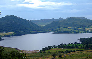
Høle or Høgsfjord is a former municipality in Rogaland county, Norway. The large municipality existed from 1865 until 1965. It was called Høgsfjord from 1865 until 1871 when the municipality was reduced in size and the name was changed to Høle. The municipality originally was quite large, surrounding both sides of the Høgsfjorden and Lysefjorden. Throughout its history, it included large parts of the present-day municipalities of Sandnes and Gjesdal. Since 1965, the area of Høle has been the borough of Høle in Sandnes municipality. Høle Church was the main church of the municipality.

<span class="mw-page-title-main">Madla (municipality)</span> Former municipality in Rogaland, Norway

Madla is a former municipality in Rogaland county, Norway. The 15.75-square-kilometre (6.08 sq mi) municipality existed from 1930 until 1965 when it was merged into Stavanger Municipality. The small municipality now exists as the borough of Madla inside the city of Stavanger, on the northeast side of the Hafrsfjorden. It was one of the smallest municipalities in Rogaland county, with only four farms: Malde, Revheim, and North- and South-Sunde. The municipal centre was located at Malde, now known as Madlamark.

<span class="mw-page-title-main">Helleland (municipality)</span> Former municipality in Rogaland, Norway

Helleland is a former municipality in Rogaland county, Norway. The 148-square-kilometre (57 sq mi) municipality existed from 1838 until its dissolution in 1965. The municipality is now located in the central part of the present-day municipality of Eigersund. The administrative centre of the municipality was the village of Helleland where the Helleland Church is located.

<span class="mw-page-title-main">Støren (municipality)</span> Former municipality in Norway

Støren  is a former municipality in the old Sør-Trøndelag county, Norway. The 266-square-kilometre (103 sq mi) municipality existed from 1838 until its dissolution in 1964. The municipality was located in the north-central part of what is now the municipality of Midtre Gauldal in Trøndelag county. The administrative center was the village of Støren where Støren Church is located.

<span class="mw-page-title-main">Stadsbygd (municipality)</span> Former municipality in Norway

Stadsbygd is a former municipality in the old Sør-Trøndelag county, Norway. The municipality existed from 1838 until its dissolution in 1964. The 137-square-kilometre (53 sq mi) municipality existed on the southern part of the Fosen peninsula, along the Trondheimsfjorden in what is now the municipality of Indre Fosen in Trøndelag county. The administrative centre was the village of Stadsbygd, just north of the Stadsbygd Church.

References

  1. "Navn på steder og personer: Innbyggjarnamn" (in Norwegian). Språkrådet.
  2. Store norske leksikon. "Hetland" (in Norwegian). Retrieved 15 March 2016.
  3. 1 2 Jukvam, Dag (1999). Historisk oversikt over endringer i kommune- og fylkesinndelingen (PDF) (in Norwegian). Statistisk sentralbyrå. ISBN   9788253746845.
  4. Rygh, Oluf (1915). Norske gaardnavne: Stavanger amt (in Norwegian) (10 ed.). Kristiania, Norge: W. C. Fabritius & sønners bogtrikkeri. pp. 199 and 42.
  5. Hansen, Tore; Vabo, Signy Irene, eds. (20 September 2022). "kommunestyre". Store norske leksikon (in Norwegian). Kunnskapsforlaget . Retrieved 1 January 2023.
  6. Hetland herad 1837-1937 : minneskrift (in Norwegian). Dreyer. 1937. p. 13.
  7. "Kommunevalgene 1963" (PDF) (in Norwegian). Oslo: Statistisk sentralbyrå. 1964. Retrieved 14 July 2020.
  8. "Kommunevalgene og Ordførervalgene 1959" (PDF) (in Norwegian). Oslo: Statistisk sentralbyrå. 1960. Retrieved 14 July 2020.
  9. "Kommunevalgene og Ordførervalgene 1955" (PDF) (in Norwegian). Oslo: Statistisk sentralbyrå. 1957. Retrieved 14 July 2020.
  10. "Kommunevalgene og Ordførervalgene 1951" (PDF) (in Norwegian). Oslo: Statistisk sentralbyrå. 1952. Retrieved 14 July 2020.
  11. "Kommunevalgene og Ordførervalgene 1947" (PDF) (in Norwegian). Oslo: Statistisk sentralbyrå. 1948. Retrieved 14 July 2020.
  12. "Kommunevalgene og Ordførervalgene 1945" (PDF) (in Norwegian). Oslo: Statistisk sentralbyrå. 1947. Retrieved 14 July 2020.
  13. "Kommunevalgene og Ordførervalgene 1937" (PDF) (in Norwegian). Oslo: Statistisk sentralbyrå. 1938. Retrieved 14 July 2020.