Ombo

Last updated
Ombo
Ombo from Josneset.JPG
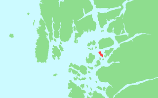
View of Ombo from Jøsneset in Hjelmeland
Norway - Ombo.png
Location in Rogaland county
Geography
Location Rogaland, Norway
Coordinates 59°15′51″N6°00′30″E / 59.2641°N 6.0083°E / 59.2641; 6.0083 Coordinates: 59°15′51″N6°00′30″E / 59.2641°N 6.0083°E / 59.2641; 6.0083
Area57.5 km2 (22.2 sq mi)
Highest elevation513 m (1,683 ft)
Highest pointBandåsen
Administration
County Rogaland
Municipalities Finnøy, Hjelmeland
Demographics
Population241 (2014)
Pop. density4.2 /km2 (10.9 /sq mi)

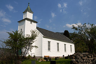
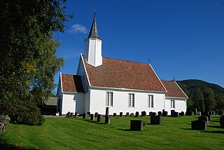
Ombo is the largest island in the Ryfylke region on the southwestern coast of Norway, and is the second largest island in Rogaland county. The 57.5-square-kilometre (22.2 sq mi) island of Ombo is divided between the municipalities Hjelmeland and Finnøy. There are several villages on the island including Jørstadvåg, Atlatveit, and Eidssund in the western part of the island which belongs to Finnøy municipality. The villages of Tuftene, Skipavik, Skår, and Vestersjø are located on the southeastern part of the island which belongs to Hjelmeland municipality. [1] Jørstad Church is located in the village of Jørstadvåg.

Ryfylke District in Rogaland, Norway

Ryfylke is a traditional district in the northeastern part of Rogaland county, Norway. The 4,546-square-kilometre (1,755 sq mi) district is located northeast of the city of Stavanger and east of the city of Haugesund and it encompasses about 60% of the county's area. It includes the mainland located northeast and east of the Boknafjorden and east of the Høgsfjorden. It also includes the islands located on the south side of the Boknafjorden. To the east, Ryfylke borders the districts of Setesdal and Sirdal, to the south is Jæren, and to the west is Haugalandet. Ryfylke is one of the 15 districts in Western Norway.

Norway constitutional monarchy in Northern Europe

Norway, officially the Kingdom of Norway, is a Nordic country in Northern Europe whose territory comprises the western and northernmost portion of the Scandinavian Peninsula; the remote island of Jan Mayen and the archipelago of Svalbard are also part of the Kingdom of Norway. The Antarctic Peter I Island and the sub-Antarctic Bouvet Island are dependent territories and thus not considered part of the kingdom. Norway also lays claim to a section of Antarctica known as Queen Maud Land.

Rogaland County (fylke) of Norway

Rogaland[²ruːɡɑlɑn](listen) is a county in Western Norway, bordering Hordaland, Telemark, Aust-Agder, and Vest-Agder counties. Rogaland is the center of the Norwegian petroleum industry. In 2016, Rogaland had an unemployment rate of 4.9%, one of the highest in Norway. In 2015, Rogaland had a fertility rate of 1.78 children per woman, which is the highest in the country.

The island is at the northeastern edge of a large group of islands in the Boknafjorden. Ombo is located north of the islands of Randøy and Halsnøya, northeast of the island of Finnøy, and east of the Sjernarøyane archipelago. The highest point on the island is the 515-metre (1,690 ft) tall Bandåsen. Ombo is surrounded by fjords that are connected to the main Boknafjorden. The Ombofjorden to the east, Gardssundfjorden to the south, Gapafjorden to the west, and Jelsafjorden to the north.

Randøy island in Hjelmeland, Norway

Randøy is an island in Hjelmeland municipality in Rogaland county, Norway. The 16.7-square-kilometre (6.4 sq mi) island lies just off the mainland between the Jøsenfjorden and the Årdalsfjorden. The large island of Ombo lies to the north and the island of Halsnøya lies to the west.

Finnøy (island) island in Finnøy municipality in Rogaland county, Norway

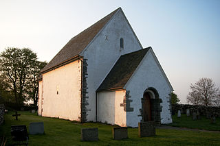
Finnøy is an island in Finnøy municipality in Rogaland county, Norway. The 25-square-kilometre (9.7 sq mi) island is one of the largest in the island municipality. The administrative centre, Judaberg, is located on the eastern shore of the island. The island is located on the southern side of the Boknafjorden, about 20 kilometres (12 mi) northeast of the city of Stavanger. The village of Hesby, on the western coast, is a historical seat of power dating back to the Middle Ages. Hesby is also the site of Hesby Church which dates back to around the year 1100.

Sjernarøyane island group

Sjernarøyane is an island group in Finnøy municipality in Rogaland county, Norway. The islands are located in the Nedstrandsfjorden, west of the large island of Ombo and north of the large island of Finnøy. As of 2014, the islands were home to 365 residents. The islands were historically part of the municipality of Sjernarøy before merging into the municipality of Finnøy in 1965. The Aubøsund strait, which runs between the islands of Aubø and Bjergøy was a historically important trading post.

After the road was built around the island of Ombo, a distinctive rock formation was visible from the new road. The rock formation looks like a face, and was originally named Adam. Among the local residents, this is also called "Ombo-gubben".

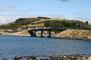
There are no outside road connections to Omboit is only accessible by boat. There are regular ferry connections that stop at Eidssund on the west coast from Judaberg, Sjernarøyane, Nedstrand, Jelsa, Halsnøya, and Fogn. There are also regular ferry connections from Skipavik on the eastern shore of the island to Nesvik and Hjelmelandsvågen on the mainland.

Judaberg Village in Western Norway, Norway

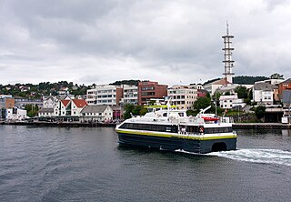
Judaberg is the administrative centre of Finnøy municipality in Rogaland county, Norway. The village is located on the eastern shore of the island of Finnøy. The island is located on the south side of the Boknafjorden, northeast of the large city of Stavanger.

Nedstrand Village in Western Norway, Norway

Nedstrand is a village in Tysvær municipality in Rogaland county, Norway. The village is located on the southeastern coast of the Nedstrand peninsula, at the confluence of the Nedstrandsfjorden and Vindafjorden. The village of Hindaråvåg lies just west of Nedstrand, and Nedstrand Church is located there. The 0.32-square-kilometre (79-acre) village of Nedstrand has a population (2014) of 240, giving the village a population density of 750 inhabitants per square kilometre (1,900/sq mi).

Jelsa, Norway Village in Western Norway, Norway

Jelsa is a village in Suldal municipality in Rogaland county, Norway. The village is located along the inner part of the Boknafjorden, near the mouths of the Sandsfjorden and Erfjorden. The village is the site of a school, store, gas station, and some small stores. There was a barrel factory here until it closed in 2009. Jelsa Church is located in this village.

See also

Related Research Articles

Hjelmeland Municipality in Rogaland, Norway

Hjelmeland  is a municipality in Rogaland county, Norway. It is located in the traditional district of Ryfylke. The administrative centre of the municipality is the village of Hjelmelandsvågen. Other villages in the municipality include Fister, Årdal, and Jøsenfjorden.

Suldal Municipality in Rogaland, Norway

Suldal is a municipality in the northeast corner of Rogaland county, Norway. It is located in the traditional district of Ryfylke. Since 1965, the administrative centre of Suldal is the village of Sand i Ryfylke. Other villages in Suldal include Hålandsosen, Jelsa, Marvik, Nesflaten, and Suldalsosen.

Rennesøy Municipality in Rogaland, Norway

Rennesøy is an island municipality in Rogaland county, Norway. It is located in the traditional district of Ryfylke. The administrative centre of the municipality is the village of Vikevåg. Other villages in Rennesøy include Askje and Sørbø. The municipality encompasses a number of islands on the south side of the Boknafjorden, north of the city of Stavanger.

Leirvik Town in Western Norway, Norway

Leirvik is a town and the administrative centre of Stord municipality in Hordaland county, Norway. The town lies along the southern coast of the large island of Stord, along the Hardangerfjorden. The town gained "town status" in 1997. The town includes the Eldøyane peninsula where the large Kværner Stord industrial area is located.

Fister Village in Western Norway, Norway

Fister is a village in Hjelmeland municipality in Rogaland county, Norway. The village is located on the mainland, along the Fisterfjorden, a branch off the main Boknafjorden. The village lies about 8 kilometres (5.0 mi) northwest of the village of Årdal and about 10 kilometres (6.2 mi) southwest of the municipal centre of Hjelmelandsvågen.

Boknafjord human settlement

Boknafjord or Boknafjorden is a fjord located in Rogaland county, Norway. The huge fjord lies between the cities Stavanger and Haugesund, and the main part of the fjord is shared between the municipalities of Kvitsøy, Rennesøy, Finnøy, Tysvær, Bokn, and Karmøy. There are dozens of smaller fjords that branch off the main part of the fjord, reaching most municipalities in the county. At its longest, the Boknafjord reaches about 96 kilometres (60 mi) into the mainland at the innermost point of the Hylsfjorden. Other notable branches include the Saudafjorden, Sandsfjorden, Vindafjorden, Hervikfjorden, Førresfjorden, Erfjorden, Jøsenfjorden, Årdalsfjorden, Idsefjorden, Høgsfjorden, Lysefjorden, and Gandsfjorden.

Hjelmelandsvågen Village in Western Norway, Norway

Hjelmelandsvågen is the administrative centre of Hjelmeland municipality, Norway. The village is located on the south side of the mouth of the Jøsenfjorden. The 0.67-square-kilometre (170-acre) village has a population (2015) of 558, giving the village a population density of 833 inhabitants per square kilometre (2,160/sq mi).

Talgje

Talgje is a populated island in southwestern Finnøy municipality in Rogaland county, Norway. The 4.1-square-kilometre (1.6 sq mi) island is located in the Talgjefjorden and Brimsefjorden, both arms off of the main Boknafjorden in a large archipelago of islands northeast of the city of Stavanger. It is surrounded by islands: Brimse to the south, Rennesøy to the west, Finnøy to the north, and Fogn to the northeast. The island has a lot of agricultural uses, especially in growing tomatoes.

Jelsa (municipality) Former Municipality in Western Norway, Norway

Jelsa is a former municipality in Rogaland county, Norway. The 130-square-kilometre (50 sq mi) municipality existed from 1838 until 1965. It encompassed area in the present-day municipalities of Suldal, Hjelmeland, and Finnøy that surround the Sandsfjorden. The administrative centre was the village of Jelsa, where Jelsa Church is located.

Nedstrand (municipality) Former Municipality in Western Norway, Norway

Nedstrand is a former municipality in Rogaland county, Norway. The 119-square-kilometre (46 sq mi) municipality was located along the Nedstrandfjorden, an inner branch off the main Boknafjorden. The municipality encompassed the majority of the Nedstrand peninsula. Originally it also included the Sjernarøyane islands and the western part of the island of Ombo in the fjord to the south. The administrative centre of the municipality was the village of Nedstrand. Nedstrand Church is located in Hindaråvåg, a small village just west of Nedstrand village. Today, the area is part of the large municipality of Tysvær.

Halsnøya, Rogaland

Halsnøya is an island in Finnøy municipality in Rogaland county, Norway. The 4.9-square-kilometre (1.9 sq mi) island is the largest island in of the Fisterøyene archipelago. Halsnøya is located south of the island of Ombo, southeast of the Sjernarøyane islands, east of the island of Finnøy, northeast of the island of Fogn, and west of the island of Randøy. The island is only accessible by boat, with regular ferry service from the nearby islands and to the mainland.

Fister (municipality) Former Municipality in Western Norway, Norway

Fister is a former municipality in Rogaland county, Norway. The 47-square-kilometre (18 sq mi) municipality existed from 1884 until 1965. It was located in the present-day municipalities of Finnøy and Hjelmeland. The administrative centre of the municipality was the village of Fister, where the Fister Church is located. The municipality encompassed the western coast of mainland along the Fisterfjorden plus the islands to the west of the mainland, including the western part of Randøy and Halsnøya.

References

  1. Store norske leksikon. "Ombo" (in Norwegian). Retrieved 2016-01-08.