
Hauge or Hauge i Dalane is the administrative center of Sokndal municipality in Rogaland county, Norway. It is located along the river Sokno, between the coastal villages of Rekefjord and Sogndalsstranda. Sokndal Church is located in the village.

Erfjord is a former municipality in Rogaland county, Norway. The 132-square-kilometre (51 sq mi) municipality existed from 1914 until 1965. It encompassed the area around the Erfjorden in the southwestern part of the present-day municipality of Suldal. The administrative centre of the municipality was the village of Hålandsosen, where the Erfjord Church is located.

Røldal is a village in the municipality of Odda in Hordaland county, Norway. The village lies in the Røldal valley along the Storelva river on the north end of the lake Røldalsvatnet. Røldal is located about 35 kilometres (22 mi) southeast of the town of Odda. Røldal was formerly part of the independent municipality of Røldal from 1838 until 1964 when it became a part of Odda municipality. The 13th-century Røldal Stave Church is located here.

Holmavatnet is a lake the Setesdalsheiene mountains of Southern Norway. It is located on the border of the municipalities of Suldal, Vinje, and a small part in Bykle. The southeastern corner of the lake is in Bykle, and it is the northernmost part of all of Aust-Agder county. The lake Skyvatn is located about 5 kilometres (3.1 mi) to the south of the lake.
Holmevatnet or Holmevatn is a lake in the Setesdalsheiene area of Norway. It is located in the mountains on the border of the municipalities of Bykle in Aust-Agder county and Suldal in Rogaland county. The 4.76-square-kilometre (1.84 sq mi) lake lies just west of the lake Store Urevatn and to the northeast of the lake Blåsjø. The nearest villages are Berdalen in Bykle, about 20 kilometres (12 mi) to the east and Suldalsosen, about 30 kilometres (19 mi) to the west. The mountain Kaldafjellet lies about 6 kilometres (3.7 mi) north of the lake.

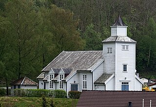
Imsland is a former municipality in Rogaland county, Norway. The 90-square-kilometre (35 sq mi) municipality existed from 1923 until its dissolution in 1965. The municipality included the area surrounding the inner part of the Vindafjorden in the present-day municipalities of Suldal and Vindafjord. The administrative centre of Imsland was the village of Imslandsjøen where Imsland Church is located.

Sand is the administrative centre of the municipality of Suldal in Rogaland county, Norway. The village lies on the shore of the Sandsfjorden at the mouth of the river Suldalslågen, just south of the mouth of the Hylsfjorden. The 1-square-kilometre (250-acre) village has a population (2013) of 1149, giving the village a population density of 1,149 inhabitants per square kilometre (2,980/sq mi).
Sandsfjorden or Sandsfjord is a fjord in Suldal Municipality in Rogaland county, Norway. The 25-kilometre (16 mi) long fjord is the northernmost arm of main Boknafjorden in Rogaland county. The fjord begins at the confluence of the Saudafjorden and Hylsfjorden, just north of the village of Sand. It then travels to the southwest until it reaches the island of Foldøy, where the fjord joins the main Boknafjorden. The villages of Jelsa and Hebnes are located on either side of the mouth of the fjord.

Nesflaten is a village in Suldal municipality in Rogaland county, Norway. The village is located on the northern end of the lake Suldalsvatnet, just west of the smaller village of Roalkvam. Nesflaten lies along the Norwegian National Road 13 which connects it to the village of Suldalsosen to the southwest and to the village of Botnen. Nesflaten Chapel is located in the village.
Storheddernuten or Storhidlernuten is a mountain on the border of Aust-Agder and Rogaland counties in southern Norway. The 1,402-metre (4,600 ft) tall mountain has a topographic prominence of 70 metres (230 ft). The mountain sits on the border of the municipalities of Suldal in Rogaland and Bykle in Aust-Agder. The mountain is the 21st highest mountain in Aust-Agder county.
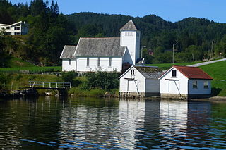
Hålandsosen is a village in Suldal municipality in Rogaland county, Norway. The village is located along the eastern shore of the Erfjorden, about 13 kilometres (8.1 mi) east of the village of Jelsa and about 15 kilometres (9.3 mi) south of the municipal centre of Sand. The Norwegian National Road 13 runs through the village, and the Erfjord Bridge lies just north of the village. It is the only bridge over the Erfjorden.

Sand is a former municipality in Rogaland county, Norway. The 221-square-kilometre (85 sq mi) municipality encompassed the area around the Hylsfjorden and the inner part of the Sandsfjorden. The administrative centre of the municipality was the village of Sand where Sand Church is located.

Suldalsosen is a village in Suldal municipality in Rogaland county, Norway. The village is located along the northern shore of the river Suldalslågen on the southwestern end of the lake Suldalsvatnet. Suldalsosen historically was a central starting point for boat traffic on the lake. This was the administrative centre of Suldal municipality prior to 1965 when the municipality was greatly expanded and the administration was moved to Sand.
Marvik is a village in Suldal municipality in Rogaland county, Norway. The village is located along the Sandsfjorden on the southern coast of the Ropeid peninsula. The village is a commercial centre of the peninsula, having a general store, primary school, marina, library, and Marvik Chapel.

Suldal Church is a parish church in Suldal municipality in Rogaland county, Norway. It is located in the village of Suldalsosen. The church is part of the Suldal parish in the Ryfylke deanery in the Diocese of Stavanger. The present church was built in 1852 and it seats about 600 people. It sits on the shore of the river Suldalslågen, at the southern end of the lake Suldalsvatnet.
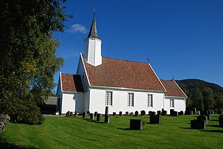
Jelsa Church is a parish church in Suldal municipality in Rogaland county, Norway. It is located in the village of Jelsa. The church is part of the Jelsa parish in the Ryfylke deanery in the Diocese of Stavanger. The white, wooden church was built in 1647. The church seats about 150 people.
Imslandsjøen or Imsland is a village in Vindafjord municipality in Rogaland county, Norway. The village is located on the northern shore of the Vindafjorden, about 5 kilometres (3.1 mi) southeast of the village of Vikedal and about 12 kilometres (7.5 mi) west of the village of Sand in neighboring Suldal municipality. Imsland Church is located in the village.


