Vindafjord is a municipality in Rogaland county, Norway. It is part of the traditional district of Haugaland. Since 2005, the administrative centre of the municipality has been the village of Ølensjøen, prior to that time it was the village of Sandeid. Other villages in the municipality include Bjoa, Imslandsjøen, Ølensvåg, Skjold, Vats, Vikebygd, and Vikedal. The municipality is centered on the Vindafjorden and Sandeidfjorden in the east and it lies north and east of the Skjoldafjorden in the west.

Saudafjord or Saudafjorden is a fjord in Rogaland county, Norway. The fjord stretches from the town of Sauda in the municipality of Sauda in the north to the village of Sand in the municipality of Suldal where the Saudafjorden and Hylsfjorden join together to form the Sandsfjorden.

Hauge or Hauge i Dalane is the administrative center of Sokndal municipality in Rogaland county, Norway. It is located along the river Sokno, between the coastal villages of Rekefjord and Sogndalsstranda. Sokndal Church is located in the village.

Ogna is a village in Hå municipality in Rogaland county, Norway. The village is located immediately north of the village of Sirevåg on the shores of the Ognaelva river. The village was the administrative centre of the historic municipality of Ogna. The village is the site of Ogna Station, a railway station along the Sørlandet Line.

Erfjord is a former municipality in Rogaland county, Norway. The 132-square-kilometre (51 sq mi) municipality existed from 1914 until 1965. It encompassed the area around the Erfjorden in the southwestern part of the present-day municipality of Suldal. The administrative centre of the municipality was the village of Hålandsosen, where the Erfjord Church is located.

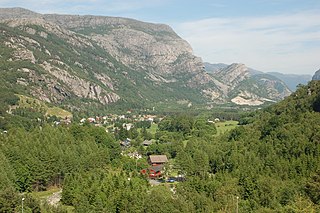
Røldal is a village in the municipality of Odda in Hordaland county, Norway. The village lies in the Røldal valley along the Storelva river on the north end of the lake Røldalsvatnet. Røldal is located about 35 kilometres (22 mi) southeast of the town of Odda. Røldal was formerly part of the independent municipality of Røldal from 1838 until 1964 when it became a part of Odda municipality. The 13th-century Røldal Stave Church is located here.

The Suldalslågen is a river that is located in the municipality of Suldal in Rogaland county, Norway. The 22-kilometre (14 mi) long river runs from the lake Suldalsvatnet to the southwest to the village of Sand where it empties into the Sandsfjorden. The Norwegian National Road 13 runs along the river, past the villages of Suldal and Sand.

Holmavatnet is a lake the Setesdalsheiene mountains of Southern Norway. It is located on the border of the municipalities of Suldal, Vinje, and a small part in Bykle. The southeastern corner of the lake is in Bykle, and it is the northernmost part of all of Aust-Agder county. The lake Skyvatn is located about 5 kilometres (3.1 mi) to the south of the lake.

Suldalsvatnet is the sixth-deepest lake in Norway. The 376-metre (1,234 ft) deep lake lies in the municipality of Suldal in Rogaland county, Norway. The 28-square-kilometre (11 sq mi) lake is the headwaters of the river Suldalslågen and it sits at an elevation of 69 metres (226 ft) above sea level. The lake has a volume of 4.49 cubic kilometres (1.08 cu mi).
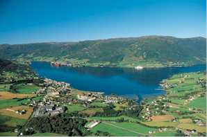
Sandeid is a village in Vindafjord municipality in Rogaland county, Norway. The village is located at the head of the Sandeidfjorden, about 7 kilometres (4.3 mi) northwest of the village of Vikedal and about 11 kilometres (6.8 mi) south of the village of Ølensjøen. The 0.61-square-kilometre (150-acre) village has a population (2013) of 622, giving the village a population density of 1,020 inhabitants per square kilometre (2,600/sq mi).

Imsland is a former municipality in Rogaland county, Norway. The 90-square-kilometre (35 sq mi) municipality existed from 1923 until its dissolution in 1965. The municipality included the area surrounding the inner part of the Vindafjorden in the present-day municipalities of Suldal and Vindafjord. The administrative centre of Imsland was the village of Imslandsjøen where Imsland Church is located.
Vassdalseggi is the tallest mountain in Rogaland county, Norway. The 1,658-metre (5,440 ft) tall mountain sits on the border of the municipalities of Vinje and Suldal. Vassdalseggi lies in the Ryfylkeheiane mountains about 5 kilometres (3.1 mi) north of the mountain Fitjanuten and about 2.5 kilometres (1.6 mi) southeast of the mountain Kistenuten.
Sandsfjorden or Sandsfjord is a fjord in Suldal Municipality in Rogaland county, Norway. The 25-kilometre (16 mi) long fjord is the northernmost arm of main Boknafjorden in Rogaland county. The fjord begins at the confluence of the Saudafjorden and Hylsfjorden, just north of the village of Sand. It then travels to the southwest until it reaches the island of Foldøy, where the fjord joins the main Boknafjorden. The villages of Jelsa and Hebnes are located on either side of the mouth of the fjord.

Ulla-Førre is a hydropower complex in Suldal, Hjelmeland and Bykle in Norway. It has an installed capacity of approximately 2,100 MW, and the annual average production is 4.45 TWh (16.0 PJ) (1987-2006), while its annual potential is about 7.8 TWh (28 PJ). The complex includes the artificial lake Blåsjø, which is made by dams around 1,000 metres (3,300 ft) above the sea level. The hydroelectric power station in the complex are Saurdal, Kvilldal, Hylen and Stølsdal, operated by Statkraft.

Hylsfjorden or Hylsfjord is a fjord in the municipality Suldal in Rogaland county, Norway. The 20-kilometre (12 mi) long fjord runs from the small area of Hylen to the west. It ends just north of the village of Sand where it joins the Saudafjorden and together they form the Sandsfjorden, an inner branch of the Boknafjorden. The 160-megawatt (210,000 hp) Hylen Hydroelectric Power Station is located in the inner end of Hylsfjord. The fjord has relatively little development along its shores, only a few small hamlets, with Vanvik being the largest.
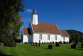
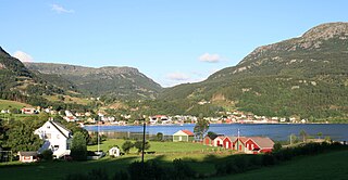
Jelsa is a former municipality in Rogaland county, Norway. The 130-square-kilometre (50 sq mi) municipality existed from 1838 until 1965. It encompassed area in the present-day municipalities of Suldal, Hjelmeland, and Finnøy that surround the Sandsfjorden. The administrative centre was the village of Jelsa, where Jelsa Church is located.

Sand is a former municipality in Rogaland county, Norway. The 221-square-kilometre (85 sq mi) municipality encompassed the area around the Hylsfjorden and the inner part of the Sandsfjorden. The administrative centre of the municipality was the village of Sand where Sand Church is located.

Suldalsosen is a village in Suldal municipality in Rogaland county, Norway. The village is located along the northern shore of the river Suldalslågen on the southwestern end of the lake Suldalsvatnet. Suldalsosen historically was a central starting point for boat traffic on the lake. This was the administrative centre of Suldal municipality prior to 1965 when the municipality was greatly expanded and the administration was moved to Sand.
Oltedal is a village in Gjesdal municipality in Rogaland county, Norway. The village is located in a narrow river valley about 11 kilometres (6.8 mi) northeast of the municipal centre of Ålgård and about 9 kilometres (5.6 mi) west of the village of Dirdal, just west of the Høgsfjorden. The lake Oltedalsvatnet lies on the southwestern edge of the village. Oltedal Church is located in the village. The village has some small industries such as yarn making, chemicals, and sand/gravel pits.


