
Eidfjord is a municipality in Vestland county, Norway. The municipality is located in the traditional district of Hardanger. The administrative centre of the municipality is the village of Eidfjord, where the majority of the municipal population lives. The other major population centre in the municipality is the village of Øvre Eidfjord.

Ulvik is a municipality in Vestland county, Norway. The municipality stretches from the Hardangerfjord to the mountains that reach 1,800 metres (5,900 ft) above sea level. The administrative centre of the municipality is the village of Ulvik. The villages of Osa and Finse are also located in Ulvik municipality.
Granvin is a former municipality in the old Hordaland county, Norway. The municipality existed from 1838 until its dissolution in 2020 when it merged with Voss Municipality. The municipality was located in the traditional district of Hardanger. The administrative centre of Granvin was the village of Eide, which is also called "Granvin". About half of the residents of the municipality lived in the municipal centre. The rest lived in the rural valley areas surrounding the Granvin Fjord or the lake Granvinsvatnet in the central part of the municipality.

Os is a former municipality in the old Hordaland county, Norway. It was located in the Midhordland region, just south of Norway's second-largest city, Bergen. Due to its proximity to Bergen, Os experienced strong population growth. The administrative centre of Os was the village of Osøyro. It is the largest settlement in the municipality, with over 60% of the municipal residents living here. Other large villages in Os included Hagavik, Halhjem, Søfteland, Søre Øyane, and Søvik.

Midsund is a former municipality in Møre og Romsdal county, Norway. It was part of the Romsdal region. The administrative centre was the village of Midsund on Otrøya island. Other settlements on the island included Uglvik and Raknes in the north and Nord-Heggdal in the southeast.
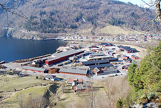
Leirvik is a town and the administrative centre of Stord municipality in Vestland county, Norway. The town lies along the southern coast of the large island of Stord, along the Hardangerfjorden. The town gained "town status" in 1997. The town includes the Eldøyane peninsula where the large Kværner Stord industrial area is located.

The Hardanger Bridge is a suspension bridge across the Eidfjorden branch off of the main Hardangerfjorden in Vestland county, Norway. The bridge connects the municipalities of Ullensvang and Ulvik. It replaced a ferry connection between Bruravik and Brimnes, and thereby shortens the driving time between Oslo and Bergen. It is the longest suspension bridge in Norway.
Nordfold is a village in Steigen Municipality in Nordland county, Norway. The village of Nordfold lies along the Nordfolda, a northern branch of the main Folda fjord. It lies about 15 kilometres (9.3 mi) east of the municipal centre of Leinesfjorden. It is the location of the Nordfold Church.
Hollingen is a village in Møre og Romsdal county, Norway. The village is mostly in Aukra Municipality, but about 1/3rd of the village area lies to the north of the municipal border inside Hustadvika Municipality. It is located on the Romsdal peninsula along the Julsundet strait about 15 kilometres (9.3 mi) northwest of the city of Molde. The village is mostly located on the small part of Aukra that is located on the mainland. The village has ferry service across the Julsundet strait to the village of Aukrasanden on Gossa.

Norddalsfjorden is a branch off of the main Storfjorden in Møre og Romsdal county, Norway. The fjord is located in Fjord Municipality and a small part is also in Stranda Municipality. The fjord is 16 kilometres (9.9 mi) long, when you include the Tafjorden arm that stretches further east, it is 24 kilometres (15 mi) in total. In the Middle Ages, the combined Norddalsfjorden and Tafjorden were probably called «Todarfjorden» (Tafjorden). Norwegian County Road 63 and Norwegian County Road 650 runs along the fjord and includes a ferry crossing between Eidsdal and Linge. In the 1960s villages Stranda-Liabygda-Eidsdal-Valldal-Norddal-Fjørå-Tafjord were still connected by a web of ferry crossings.

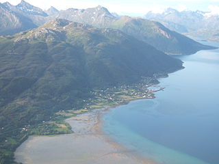
Ulvik is a village in the municipality of Ulvik which is located in Vestland county, Norway. The village sits at the end of the Ulvikafjorden, a side arm off of the main Hardangerfjord. The village lies about 15 kilometres (9.3 mi) north of the Hardanger Bridge and about 30 kilometres (19 mi) east of the village of Vossevangen. The 0.62-square-kilometre (150-acre) village has a population (2019) of 534 and a population density of 861 inhabitants per square kilometre (2,230/sq mi).

The Osa Fjord is a branch of the Eid Fjord and the Hardanger Fjord fully located within the municipality of Ulvik in Vestland county, Norway. The fjord is 13 kilometres (8.1 mi) long, with a maximum depth of 302 metres (991 ft) at its mouth, and it runs northeast from its mouth between Bruravik and Bagnsnes to the head of the fjord at the small village of Osa.
The Bjarkøy Fixed Link is a fixed link which connects the three islands of Bjarkøya, Sandsøya, and Grytøya in Harstad Municipality in Troms og Finnmark county, Norway. The fixed link was completed in late 2018. A subsea road tunnel connects the islands of Grytøya and Bjarkøya, and a bridge connects the islands of Grytøya and Sandsøya. The tunnel to Bjarkøya is 3.25 kilometres (2.02 mi) long. The bridge to Grytøya is 300 metres (980 ft) long plus a 900-metre (3,000 ft) long causeway. The project also included 3 kilometres (1.9 mi) of new road on Grytøya to connect the existing roads to the new undersea tunnel. The Bjarkøy Tunnel is designated as part of Norwegian County Road 867, while the Sandsøya Bridge is part of Norwegian County Road 124.

Sølsnes is a village in Molde Municipality in Møre og Romsdal county, Norway. The village is located on the Romsdal Peninsula at the confluence of the Karlsøyfjorden and the Langfjorden. The village of Nesjestranda lies about 2.5 kilometres (1.6 mi) north of Sølsnes. The Old Veøy Church is located on the island of Veøya, off the coast from Sølsnes. That church is now a museum and it was replaced in 1907 by a new Veøy Church which was built in Sølsnes.

Norwegian County Road 680 is a road in the municipalities of Kristiansund and Aure in Møre og Romsdal county and Heim in Trøndelag county, Norway. In addition to its 111.6-kilometer (69.3 mi) land length, the route also includes the 7.0-kilometer (4.3 mi) Seivika–Tømmervåg Ferry across the Talgsjø channel.

Djønno is a small village on the Oksen Peninsula in the municipality of Ullensvang in Norway's Hardanger district, in Hordaland county.

The Eid Fjord is the innermost part of the Hardanger Fjord in Norway. It extends 29 kilometers (18 mi) eastwards from the Utne Fjord and Sørfjorden. The Eid Fjord lies in the municipalities of Ullensvang, Ulvik, and Eidfjord in Vestland county.

Brimnes is a small village in the municipality of Eidfjord in Vestland county, Norway.

The Bruravik–Brimnes Ferry was a Norwegian ferry connection across the Hardanger Fjord between Bruravik in the municipality of Ulvik and Brimnes in the municipality of Eidfjord. The ferry connected Norwegian County Road 7 and Norwegian National Road 13, and before it was discontinued it was operated by the company Fjord1 and served by MF Sogn with up to three departures per hour. The crossing lasted about 12 minutes. In the summer of 2013 the route was also served by MF Sognefjord.

Ringøy is a small village in the municipality of Eidfjord in Hordaland county, Norway.

