
A cable-stayed bridge has one or more towers, from which cables support the bridge deck. A distinctive feature are the cables or stays, which run directly from the tower to the deck, normally forming a fan-like pattern or a series of parallel lines. This is in contrast to the modern suspension bridge, where the cables supporting the deck are suspended vertically from the main cable, anchored at both ends of the bridge and running between the towers. The cable-stayed bridge is optimal for spans longer than cantilever bridges and shorter than suspension bridges. This is the range within which cantilever bridges would rapidly grow heavier, and suspension bridge cabling would be more costly.

Østfold is a county in Eastern Norway, which from 1 January 2020 to 31 December 2023 was part of Viken. Østfold borders Akershus and southwestern Sweden, while Buskerud and Vestfold are on the other side of Oslofjord. The county's administrative seat was Sarpsborg. The county controversially became part of the newly established Viken County on 1 January 2020. On 1 January 2024, Østfold is re-established as an independent county, however without the former municipality of Rømskog, which was amalgamated with the Akershus municipality Aurskog-Høland in 2020.

Askim is a town and a former municipality in Indre Østfold Kommune in the former county of Østfold county, Norway.

Ting Kau Bridge is a 1,177-metre (3,862 ft) long cable-stayed bridge in Hong Kong that spans from the northwest of Tsing Yi Island and Tuen Mun Road. It is near the Tsing Ma Bridge which also serves as a major connector between the Hong Kong International Airport on Lantau Island and the rest of Hong Kong. It was completed on 5 May 1998. The bridge is toll-free.

European route E18 runs from Craigavon in Northern Ireland to Saint Petersburg in Russia, passing through Scotland, England, Norway, Sweden and Finland. It is about 1,890 kilometres in length.

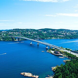
The Nordhordland Bridge is a combined cable-stayed and pontoon bridge which crosses Salhusfjorden between Klauvaneset and the island of Flatøy in Vestland county, Norway. It is 1,614 meters (5,295 ft) long, of which the pontoon section is 1,246 meters (4,088 ft) long. The cable-stayed section consists of a single 99-meter (325 ft) tall H-pylon which has a length of 368 meters (1,207 ft) and a main span of 172 meters (564 ft). This allows for a clearance of 32 meters (105 ft).

An extradosed bridge employs a structure that combines the main elements of both a prestressed box girder bridge and a cable-stayed bridge. The name comes from the word extrados, the exterior or upper curve of an arch, and refers to how the "stay cables" on an extradosed bridge are not considered as such in the design, but are instead treated as external prestressing tendons deviating upward from the deck. In this concept, they remain part of the main bridge superstructure.

The Bandra-Worli Sea Link is a 5.6 km long, 8-lane wide cable-stayed bridge that links Bandra in the Western Suburbs of Mumbai with Worli in South Mumbai. It is the longest sea bridge, as well as the 5th longest bridge in India after Mumbai Trans Harbour Link, Bhupen Hazarika Setu, Dibang River Bridge and Mahatma Gandhi Setu. It contains pre-stressed concrete-steel viaducts on either side. It was planned as a part of the proposed Western Freeway that would link the Western Suburbs to Nariman Point in Mumbai's main business district, but is now planned to become part of the Coastal Road to Kandivali.

The Svinesund Bridge is a through arch bridge crossing Iddefjord at Svinesund, and joining Sweden and Norway. Svinesund is a sound separating the Swedish municipality of Strömstad from the Norwegian municipality of Halden, and thus it is the border between Norway and Sweden in this region. The bridge is the westernmost border crossing between the two countries and carries the European route E6 which is a major traffic route in the area, connecting Oslo and the rest of Norway with Gothenburg, Malmö, Copenhagen and the rest of Europe.

The Seri Saujana Bridge is a main bridge in the planned city Putrajaya, the new (2001) Malaysian federal territory and administrative centre. The bridge's design is a unique combination of a symmetric cable-stayed structure and a through-arch bridge; the through-arch bridge portion is reminiscent of a slender version of the Sydney Harbour Bridge in Sydney, New South Wales, Australia.

Grenland Bridge is Norway's highest cable-stayed bridge with a tower height of 168 metres (551 ft). The bridge, which opened in 1996, is part of the European Route E18 highway and it crosses the Frierfjord, a fjord in Vestfold og Telemark county. The bridge connects the town of Brevik in Porsgrunn Municipality to the town of Stathelle in Bamble Municipality. When built, it replaced Brevik Bridge (Breviksbrua) as the primary route across the fjord.
The Varodd Bridges are two parallel cantilever bridges in Kristiansand municipality, in Agder county, Norway, and they cross the Topdalsfjorden. They are named after the peninsula on the western shore. It goes from Vige and ends in Søm in Kristiansand. The bridges carry the European route E18 highway over the fjord.
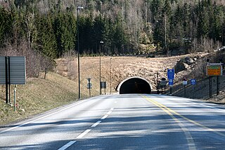
The Oslofjord Tunnel is a subsea road tunnel which traverses the Oslofjord, connecting Hurum and Frogn in Norway. Carrying three lanes, the 7,306-meter (23,970 ft) long tunnel reaches a depth of 134 meters (440 ft) below mean sea level. The tunnel has a maximum gradient of seven percent. It acts as the main link connecting eastern and western Viken county, supplementing the Moss–Horten Ferry which runs further south. The tunnel is since 2018 a part of European route E134, until 2018 it was part of National Road 23.

The Hardanger Bridge is a suspension bridge across the Eidfjorden branch off of the main Hardangerfjorden in Vestland county, Norway. The bridge connects the municipalities of Ullensvang and Ulvik. It replaced a ferry connection between Bruravik and Brimnes, and thereby shortens the driving time between Oslo and Bergen. It is the longest suspension bridge in Norway.
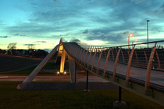
The Vebjørn Sand da Vinci Project built a laminated-wood parabolic-arch pedestrian bridge in Norway over European route E18 in Ås, Norway, in 2000. It was a partnership between the Norwegian Public Roads Administration and the Norwegian painter and artist Vebjørn Sand, who headed the project. The resulting da Vinci Bridge is one of several installations for which Sand is known in Norway.
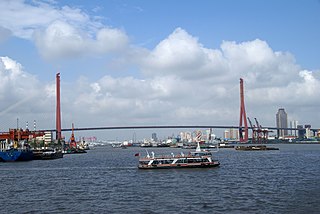
The Yangpu Bridge is a sister bridge to the Nanpu Bridge, both crossing the Huangpu River in Shanghai, China. Yangpu is among the world's longest bridges, with a total length of 8354 meters. Its longest span of 602 m makes it one of the longest cable-stayed bridges in the world. It carries the Inner Ring Road from the Yangpu District in Puxi to the Pudong New Area. It was completed in September 1993 and opened in October. It is the last vehicular bridge over the Huangpu River before the river empties into the sea.

The Nipigon River Bridge is a cable-stayed bridge in Canada carrying Highway 11 and Highway 17, designated as part of the Trans-Canada Highway, across the Nipigon River near Nipigon, Ontario.

The Dongshuimen Bridge and the Qiansimen Bridge, known collectively as the Twin River Bridges, are a pair of bridges that form a road and rail connection in Chongqing, China. Consisting of two cable-stayed bridges and a tunnel across the Yuzhong peninsula where the heart of Chongqing's commercial & financial district Jiefangbei CBD is located, the connection opened in 2014.

Sarp Bridge is a series of bridges which span across Sarpefossen, a waterfall of the river Glomma in Sarpsborg, Norway. In the current arrangement, one bridge carries a pathway, one carries a single track of the Østfold Line and one carries two lanes of National Road 118. The road and pathway bridges are about 91 meters (299 ft) long, while the railway bridge is 247 meters (810 ft).

The Farrisbrua is a major road bridge crossing the Farris lake just north of Larvik, Norway. The bridge is part of the expansion of the E18 motorway from the antiquated single carriageway to modern dual carriageway standards, enabling increased speeds and traffic volumes between the eastern and southern parts of the country. It was built between 2013 and 2018, to a cost of 718 million NOK.

