
In physical geography, a fjord or fiord is a long, narrow sea inlet with steep sides or cliffs, created by a glacier. Fjords exist on the coasts of Antarctica, the Arctic, and surrounding landmasses of the northern and southern hemispheres. Norway's coastline is estimated to be 29,000 km (18,000 mi) long with its nearly 1,200 fjords, but only 2,500 km (1,600 mi) long excluding the fjords.

Norway is a country located in Northern Europe in the northern and western parts of the Scandinavian Peninsula. The majority of the country borders water, including the Skagerrak inlet to the south, the North Sea to the southwest, the North Atlantic Ocean to the west, and the Barents Sea to the north. It has a land border with Sweden to the east; to the northeast it has a shorter border with Finland and an even shorter border with Russia.

Nordland is one of the three northernmost counties in Norway in the Northern Norway region, bordering Troms in the north, Trøndelag in the south, Norrbotten County in Sweden to the east, Västerbotten County to the south-east, and the Atlantic Ocean to the west. The county was formerly known as Nordlandene amt. The county administration is in the town of Bodø. The remote Arctic island of Jan Mayen has been administered from Nordland since 1995. In the southern part of the county is Vega, listed on the UNESCO World Heritage Site list.

Troms is a county in northern Norway. It borders Finnmark county to the northeast and Nordland county in the southwest. Norrbotten Län in Sweden is located to the south and further southeast is a shorter border with Lapland Province in Finland. To the west is the Norwegian Sea. The county had a population of 169,610 in 2024.

Østfold is a county in Eastern Norway, which from 1 January 2020 to 31 December 2023 was part of Viken. Østfold borders Akershus and southwestern Sweden, while Buskerud and Vestfold are on the other side of Oslofjord. The county's administrative seat is Sarpsborg. The county controversially became part of the newly established Viken County on 1 January 2020. On 1 January 2024, Østfold was re-established as an independent county, however without the former municipality of Rømskog, which was amalgamated with the Akershus municipality Aurskog-Høland in 2020.

In geography, a sound is a smaller body of water usually connected to a sea or an ocean. A sound may be an inlet that is deeper than a bight and wider than a fjord; or a narrow sea channel or an ocean channel between two land masses, such as a strait; or also a lagoon between a barrier island and the mainland.

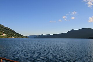
The Hardangerfjord is the fifth longest fjord in the world, and the second longest fjord in Norway. It is located in Vestland county in the Hardanger region. The fjord stretches 179 kilometres (111 mi) from the Atlantic Ocean into the mountainous interior of Norway along the Hardangervidda plateau. The innermost point of the fjord reaches the town of Odda.

Svinesund is a sound separating the Swedish municipality of Strömstad in the province of Bohuslän in the county of Västra Götaland from the Norwegian municipality of Halden in the county of Østfold.

Nordmøre is a traditional district in the Norwegian county of Møre og Romsdal. The 5,426-square-kilometre (2,095 sq mi) area comprises the northern third of the county including the municipalities of Kristiansund, Averøy, Tingvoll, Surnadal, Aure, Halsa, Eide, Sunndal, Gjemnes, and Smøla. The only town in Nordmøre is Kristiansund.

The Varangerfjord is the easternmost fjord in Norway, north of Finland. The fjord is located in Finnmark county between the Varanger Peninsula and the mainland of Norway. The fjord flows through the municipalities of Vardø, Vadsø, Nesseby, and Sør-Varanger. The fjord is approximately 100 kilometres (62 mi) long, emptying into the Barents Sea. In a strict sense, it is a false fjord, since it does not have the hallmarks of a fjord carved by glaciers.
Tista, also called Tistedalselva or Tistakanalen, is a river in Halden municipality, in Østfold county, Norway. It is the main river in the Haldenvassdraget system and flows from Femsjøen lake to Iddefjorden fjord. The river is less than 5 km long, calculated from the dam in Femsjøen to the mouth of the fjord.
Vinger Royal Road (Eskoleia) was the historical name of an ancient route in southern Norway. Historically Eskoleia was one of the most important traffic arteries between Norway and Sweden. It provided an established road leading both north and south from the Swedish border.

Wahlenbergfjorden, sometimes known in English as Waalenburg Bay, is a fjord on the southwest coast of the Arctic island of Nordaustlandet, in Norway's Svalbard archipelago. At 46 kilometres (29 mi) in length, and 15 km (9.3 mi) wide, it is the fifth longest fjord in the archipelago, and the longest on the island. The fjord separates Gustav V Land in the north from Gustav Adolf Land in the south, at geographical co-ordinates 79°40′N20°00′E. Its mouth faces Spitsbergen across Hinlopen Strait, the strait separating the two islands.
Elvestad is a well-known traffic junction area and a village in the Hobøl municipality in the Østfold county, Norway. It is where the "Riksvei" 120 and Europe Way E18 cross each other. Riksvei 120 goes between Gardermoen airport via Gjerdrum municipality in the Akershus county and Moss City in the Østfold county.

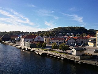
Idd is a parish and former municipality in Halden, Østfold county, Norway.

Recherche Fjord is a small fjord on the south side of Bellsund, Spitsbergen. The glacier Recherchebreen debouches into the fjord from south, and Renardbreen from west.
Grønfjorden is a 16 km long fjord, separated from Isfjorden to the north by Festningsodden in the west and Heerodden in the east. It lies within the western portion of Nordenskiöld Land. On its eastern shore is the mining community of Barentsburg, the second largest settlement on Spitsbergen.
Sandeidfjorden is a fjord in Vindafjord municipality in Rogaland county, Norway. The 9-kilometre (5.6 mi) long fjord is a northern branch of main Vindafjorden. The village of Sandeid lies at the northern end of the fjord and the village of Vikedal lies on the eastern shore near the mouth of the fjord.

The Bohus granite is a type of granite that crops out along the Swedish West Coast in Bohuslän. In Norway the same granites are termed Iddefjord granite, Østfold granite and Halden granite. A large quarrying industry has developed around the granites, mainly producing blocks. Large scale extraction begun in the 1840s and employment in the quarries peaked in the 1920s with over 7,000 people working in the industry. The rock is valued for its durability. In the first half of the 20th century the transport of quarried Bohus granite was done with the aid of by the Lysekil Line. In Norway Iddefjord granite has been a relatively common rock in architecture, and many of the statues of Frogner Park in Oslo are made of Iddefjord granite. Iddefjord granite is the official county rock of Østfold in Norway.

The Eid Fjord is the innermost part of the Hardanger Fjord in Norway. It extends 29 kilometers (18 mi) eastwards from the Utne Fjord and Sørfjorden. The Eid Fjord lies in the municipalities of Ullensvang, Ulvik, and Eidfjord in Vestland county.
