
is a municipality in Telemark county, Norway. It is located in the traditional district of Grenland. The administrative centre of the municipality is the city of Porsgrunn. Some other notable settlements in Porsgrunn include the town of Brevik and the villages of Langangen and Heistad.

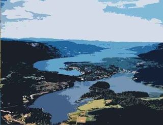
Brevik is a town in Porsgrunn Municipality in Telemark county, Norway. The town is located where the Eidangerfjorden and Frierfjorden join together to form the Breviksfjorden. Brevik is regarded as one of the best preserved towns from the sailing ship era. The town is located on the far end of Eidanger peninsula, and was a former export centre for ice and timber. The last shipment of wood to the United Kingdom was around 1960.
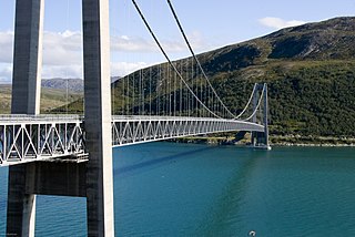
The Kvalsund Bridge is a suspension bridge in Hammerfest Municipality, Finnmark county, Norway. The bridge connects the mainland and the island of Kvaløya across the Kvalsundet strait. The bridge is located just west of the village of Kvalsund on the mainland and about 25 kilometres (16 mi) south of the town of Hammerfest.
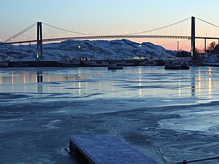
The Nærøysund Bridge is a suspension bridge that crosses the Nærøysundet strait between the islands of Marøya and Innervikna in Nærøysund in Trøndelag county, Norway. It is located about 1 kilometre (0.62 mi) south of the town of Rørvik. Together with the Marøysund Bridge, it connects the islands of Vikna to the mainland. The Nærøysund Bridge is 701 metres (2,300 ft) long, the main span is 325 metres (1,066 ft), and the maximum clearance to the sea is 41 metres (135 ft). The bridge has 17 spans. The Nærøysund Bridge was opened in 1981, when it briefly held the title of the world's longest cable-stay bridge.

The Bolsøy Bridge is a concrete beam bridge in Molde Municipality, Møre og Romsdal county, Norway. The bridge crosses the Bolsøysund strait between the mainland and the island of Bolsøya. Bolsøy Bridge was opened in 1991 as part of County Road 64, and together with the Fannefjord Tunnel, they form a ferry-free connection from the town of Molde and the island of Bolsøya to the village of Nesjestranda on the mainland.

Norddalsfjord Bridge is a cantilever bridge that crosses the Norddalsfjorden in the municipality of Kinn in Vestland county, Norway. It is the only road (non-ferry) that connects Bremanger municipality to the rest of the mainland. The bridge is 401 metres (1,316 ft) long, and the longest span is 230 metres (750 ft). The bridge was opened in 1987. It is located about 15 kilometres (9.3 mi) east of the town of Florø, 2.5 kilometres (1.6 mi) north of the village of Grov, and about 3 kilometres (1.9 mi) west of the village of Norddalsfjord.

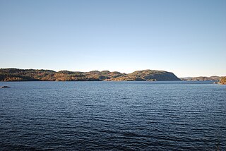
Frier or Frierfjord is a fjord in Telemark county, Norway. The 14-kilometre (8.7 mi) long fjord is located along the Skaggerak coast in the traditional district of Grenland and it forms the border with the municipalities of Bamble, Skien, and Porsgrunn. The fjord is actually an inner arm of the Langesundsfjord, and historically this fjord was also known as the Langesundsfjord. The fjord stretches from the opening to Langesundsfjord in the south to the mouth of the Porsgrunn River in the north. The much smaller fjord of Gunneklevfjord opens into the Porsgrunn/Skien River and is separated from Frierfjorden by the peninsula of Herøya.

Grenland Bridge is Norway's highest cable-stayed bridge with a tower height of 168 metres (551 ft). The bridge, which opened in 1996, is part of the European Route E18 highway and it crosses the Frierfjord, a fjord in Telemark county. The bridge connects the town of Brevik in Porsgrunn Municipality to the town of Stathelle in Bamble Municipality. When built, it replaced Brevik Bridge (Breviksbrua) as the primary route across the fjord.

Frednes Bridge is a double-leaf bascule bridge on Highway 356 in Porsgrunn Municipality in Telemark county, Norway. The 461.5-metre (1,514 ft) long bridge crosses the Porsgrunn River (Porsgrunnselva) just before it flows out into the Frierfjord at the site of Norsk Hydro's factory complex on Herøya.

Langesundsfjord, also known as the Breviksfjord, is a stretch of fjord in Telemark county, Norway. The 8-kilometre (5.0 mi) long fjord flows from the Skagerrak, between the islands of Sandøya, Bjørkøya, and Siktesøya in Porsgrunn Municipality and the mainland of Bamble Municipality.
Gunnekleivfjorden is a fjord in Porsgrunn Municipality in Telemark county, Norway. The 2-kilometre (1.2 mi) long fjord is located at the head of Frierfjord in the town of Porsgrunn.
Farris is a lake on the border of Telemark and Vestfold counties in Norway. The 20-kilometre (12 mi) long freshwater moraine-dammed lake is located mostly in Larvik Municipality in Vestfold, but the northwestern part of the lake is located in Siljan Municipality and Porsgrunn Municipality in Telemark. The large town of Larvik is located at the southern end of the lake.
Goksjø is a lake on the border of Larvik Municipality and Sandefjord Municipality in Vestfold county, Norway. The 3.5-square-kilometre (1.4 sq mi) lake is located about 5 kilometres (3.1 mi) to the northwest of the town of Sandefjord and about 2.5 kilometres (1.6 mi) to the south of the village of Kodal.

Jølstravatnet or Jølstravatn is a lake in Sunnfjord Municipality in Vestland county, Norway. The lake empties its water into the 20-kilometre (12 mi) long Jølstra river which then flows into the Førdefjorden. The impressive eastern arm of Jølstravatn is called Kjøsnesfjorden, although it is not a true fjord that is part of the sea. The villages of Skei, Helgheim, Ålhus, and Vassenden are located on the shores of the lake.

Lovatnet is a lake in the municipality of Stryn in Vestland county, Norway. It is located about 2 kilometres (1.2 mi) southeast of the village of Loen and about 6 kilometres (3.7 mi) east of the village of Olden. The lake lies just 2 kilometres (1.2 mi) southwest of the mountain Skåla. The water from the lake flows down from the mountains; especially from the Jostedalsbreen and Tindefjellbreen glaciers. It then flows out through the Loelva river into the Nordfjorden.
Eikeren or Eikern is a long, deep lake in eastern Norway. The 27.6-square-kilometre (10.7 sq mi) lake is located on the border of Øvre Eiker Municipality in Buskerud county and Holmestrand Municipality in Vestfold county. It is the largest lake in all of Vestfold county, measuring about 16 kilometres (9.9 mi) long and 2.5 kilometres (1.6 mi) wide, and reaching a depth of 158 metres (518 ft).

Elvenes (Norwegian), Jokknjargg (Skolt Sami), Johkanjárga (Northern Sami), or Jokiniemi (Kven) is a village in Sør-Varanger Municipality in Finnmark county, Norway. It is located at the mouth of the river Pasvikelva where it flows into the Bøkfjorden, a southern branch of the Varangerfjorden. The village lies about 6 kilometres (3.7 mi) east of the village of Hesseng, along the European route E105. The town of Kirkenes lies about a 10-kilometre (6.2 mi) drive to the northwest.

Østre Porsgrunn Church is a parish church of the Church of Norway in Porsgrunn Municipality in Telemark county, Norway. It is located in the town of Porsgrunn. It is one of the two churches for the Porsgrunn parish which is part of the Skien prosti (deanery) in the Diocese of Agder og Telemark. The white, concrete church was built in a modern, rectangular design in 2019 using plans drawn up by the architect Espen Surnevik. The church seats about 500 people.
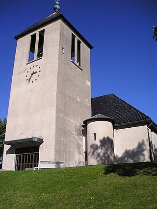
Brevik Church is a parish church of the Church of Norway in Porsgrunn Municipality in Telemark county, Norway. It is located in the village of Brevik. It is one of the churches for the Eidanger parish which is part of the Skien prosti (deanery) in the Diocese of Agder og Telemark. The grey, concrete church was built in a rectangular design in 1963 using plans drawn up by the architect Gudolf Blakstad. The church seats about 450 people.
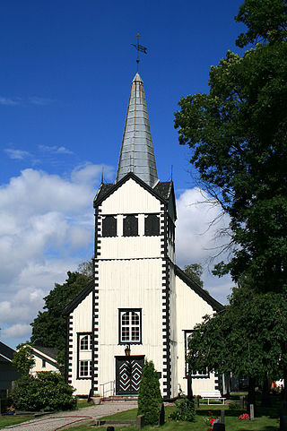
Vestre Porsgrunn Church is a parish church of the Church of Norway in Porsgrunn Municipality in Telemark county, Norway. It is located in the town of Porsgrunn. It is one of the churches for the Porsgrunn parish which is part of the Skien prosti (deanery) in the Diocese of Agder og Telemark. The white, wooden church was built in a long church design in 1758 using plans drawn up by the architects Lauritz de Thurah and Andreas Pfützner. The church seats about 170 people.

