Staro-Kalinkin Bridge

Last updated
Staro-Kalinkin Bridge
Staro-Kalinkin Bridge 1.jpg
Coordinates 59°54′59″N30°16′46″E / 59.9164°N 30.2794°E / 59.9164; 30.2794
Crosses Fontanka River
Locale Admiralteysky District of Saint Petersburg
Characteristics
Total length65.6 m
Width30.8 m
Traversable?automotive, tram, pedestrian
History
Opening1733 (wooden)
Location
Staro-Kalinkin Bridge

Staro-Kalinkin Bridge is a bridge across the Fontanka River in Admiralteysky District, Saint Petersburg. It connects Kolomensky and Bezymyany Islands. Along with Lomonosov Bridge it is one of 7 stone three-span bridges across the Fontanka built in the 1780s, which have survived to this day.

Contents

Location

The bridge is located at the mouth of the Fontanka River. From the left bank, the following are approaches to the bridge: Staro-Peterhof Avenue, Tsiolkovsky Street (near the bridge on the Fontanka Embankment). Repin Square and Lotsmanskaya Street are on the right bank. Traffic flows from Sadovaya Street to the bridge along the Fontanka River embankment.

Upstream is the English Bridge, and below is the Galerny Bridge.

The nearest metro station (1.7 km) is Narvskaya.

Name

The bridge got its name from the name of the nearby Kalinkina Village (a small Finnish village well-known since the 17th century). During its existence, the bridge has repeatedly changed its name: "Kalinkovsky Bridge" (1755), "Kalinkinsky Bridge" (1758-1875), "Kalinkin Bridge" (1763-1867). [1] Since 1820, after the appearance of the Malo-Kalinkin Bridge across the Ekaterininsky Canal (now called the Griboyedov Canal), they began to call it “Bolshoi Kalinkin.” The modern name in the form of "Old Kalinkin Bridge" appeared in 1873, since the bridge was on the same highway with Novo-Kalinkin Bridge across the Obvodny Canal. The Staro-Kalinkin Bridge variant has been well-known since 1907. [2]

History

Since 1733, there was a wooden multi-span drawbridge thrown over two branches of the Fontanka River and the Glukhaya River ( Krivushu River). [3] The length of the bridge reached 250 m. [4] In 1786 - 1788, the bridge was rebuilt according to model designs of St. Petersburg bridges across the Fontanka. The project was adapted by engineers Jan Pieter van Suchtelen and Ivan Kondratyevich Gerard. [5]

The bridge was almost indistinguishable from other tower bridges across the Fontanka: the drawbridge was made of wood and consisted of two panels opened by a simple chain mechanism. There were four granite towers topped with cornice and domes. [6] A contemporary of the Staro-Kalinkin bridge, artist Karl Friedrich Knappé depicted the form of the crossing in his artwork (the painting is now kept in The State Hermitage Museum collection). From the picture, it is possible to identify the date of the construction of the Staro-Kalinkin bridge. In addition, it is clear that the sidewalks were separated from the roadway by granite barriers, that on four sides at the entrances to the bridge there were granite obelisks with lanterns suspended from them, and that granite benches were pressed to the parapets at the openings of the structures. [6] In the drawings of 1839, the middle span is depicted as a constant, strut system. [7]

In 1877, to lay the line for the horse tram in the middle span, new trusses were made from beams with struts. [8] In 1882, over the side stone arches of the bridge, wooden decks were arranged along the girders to reduce pressure on the arches. Four granite pedestals with pillars and granite parapets were removed. [9]

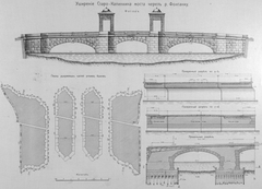
In the late 1880s, the need arose to expand the bridge for an increase in carrying capacity. In 1889, the City Council approved the bridge reconstruction project, developed by the architect M. I. Ryllo. The project included the demolition of the towers, the replacement of the middle wooden span with a brick vault, and the expansion of the bridge. [7] This decision led to sharp protests from the architectural community of St. Petersburg and the Committee for the reconstruction of bridges was forced to abandon its intentions, instructing the architect to draw up a new project. [7] According to the second project of Mikhail Ivanovich Ryllo, the bridge towers were preserved, but all other elements of the bridge decoration (sidewalk railing, obelisks with lanterns, and granite benches) were removed. March 22, 1890 highest permission was granted to rebuild the bridge, while maintaining the existing granite towers. [10] The new project was approved by the City Council in June 1890, and according to the project, from 1892 - 1893 the middle span was rebuilt. [11] Separate stages of work were covered by the magazine "Nedelya Stroitelya" (Builder's Week). [12] [13] [14] In the course of the reconstruction work, the abutments and the piers of the bridge were dismantled to the level of the pile grillage, and then restored again. The arches of the side spans were rebuilt in their historical form, and the central span was covered with a gentle circular arch that replaced the existing wooden truss. The granite towers were recreated, while the new width of the bridge structure was 15.2 m. [15]

From 1907 - 1909, for the construction of the tram line the bridge was expanded to 30.75 m by building two new bridges on the sides of the old bridge, 9.6 m wide on the upper side and 5.9 m from the lower side of the old bridge. The new spans repeated the outlines of the vaults and the system of the old bridge, i.e. three-span stone vaults, the middle span was 8.77 m and the side spans were 13.16 m each. [16] At the same time, granite towers and parapets were preserved. [15] The work was carried out by the contractor S.S. Linda. [17]

In 1965, at the initiative of "Lenmostotresta" a project was developed to restore the architectural design of the bridge. The author of the project was architect Irina Nikolaevna Benua. The project was based on the historical information compiled by Special Scientific Restoration Workshops employee R. G. Rabinovich, based on the archival materials collected by N. V. Popova. [11] One of the sources of the general view of the crossing in the 19th century was Karl Friedrich Knappe's 1840 painting "Kalinkin Bridge." As a result of restoration work, granite barriers have been restored, separating the roadway from the sidewalk; granite benches on the parapets of the bridge openings were restored, and granite obelisks with lanterns were installed near the entrances. [11] In 1969, gilding of metal decorative parts of the bridge was done. In 1989, according to the project of the architect V.M. Ivanov, the lanterns and memorial plaques on the towers were recreated. [18]

From October 2013 to April 2014, repairs were made to the bridge's road surface, tram rails and communications. [19] [20]

Construction

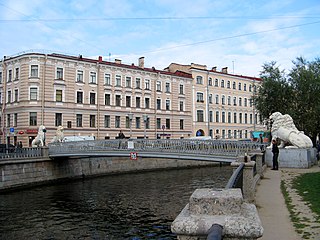
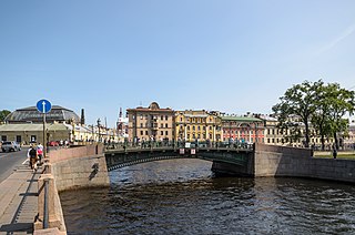
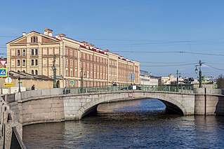
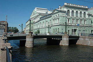
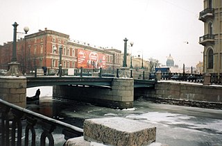
The bridge is three-span. The side spans are the same size and are covered with box-shaped stone vaults, the middle span is covered with a gentle circular arch. The total bridge width is 30.8 m, [21] including roadway which is 23.39 m and sidewalks that are 3.3 m each. The length along the alignment between the embankments is 65.6 m. [11]

The bridge is intended for the movement of trams, vehicles and pedestrians. The carriageway of the bridge includes 4 lanes for traffic and 2 tram lines. The roadway is covered with asphalt concrete, and the sidewalks are covered with granite slabs. The railing of the bridge is similar to the railing of the embankment. It has metal sections installed between the granite sections. At the entrances to the bridge, there are four granite obelisks with faceted lanterns. The sidewalks are separated from the roadway by high granite barriers that end at the entrances to the bridge.

Tower structures are made in the form of open pavilions. These consist of rustic columns that support doric entablatures and are completed with spherical domes that are further topped with spherical gilded urns. [22] [21] On the granite towers, memorial plaques are installed, indicating the dates of the beginning and end of the construction of the bridge: "1786" (on the left bank) and "1788" (on the right bank).

Related Research Articles

<span class="mw-page-title-main">Bridge of Four Lions</span> Pedestrian bridge in St Petersburg, Russia

Bridge of Four Lions is a 28-metre-long pedestrian bridge over the Griboedov Canal in St Petersburg, connecting L'vinyi Drive to Malaya Podyacheskaya Street. The Lion Bridge is in the Admiralteysky District of St. Petersburg, connecting the Kazansky and Spassky Islands. Its abutments are crowned with four cast iron sculptures of lions, which give the bridge its name. The structure, suspended by cables emerging from the mouths of lions, was constructed in 1825 according to the design of two well-established bridge builders, Wilhelm von Traitteur and Basil Christianovicz. It is an outstanding monument of bridge-building architecture of the first quarter of the 19th century [5]. It is also one of the three surviving pedestrian chain bridges in St. Petersburg.

<span class="mw-page-title-main">Bolshoy Obukhovsky Bridge</span> Bridge in Saint Petersburg, Russia

The Great Obukhovo Bridge is the newest bridge across the Neva River in Saint Petersburg, Russia. It is the only bridge across the Neva which is not a drawbridge. One of the longest bridges in Russia, it is the first fixed bridge and largest bridge across the Neva. Of course it is the largest bridge in St. Petersburg by the size of the covered span. It is located in Nevsky District, in the middle stream of the Neva. It connects Obukhovskaya Oborony Avenue with the Oktyabrskaya embankment. It is a cable-stayed bridge; the steel wire ropes are the key element of the supporting construction. But what looks like a bridge is actually two identical twin bridges with opposite directions of movement along them. One is located upstream of the Neva (southern) and is for driving eastward, the other downstream (north) is for driving in a western direction.

<span class="mw-page-title-main">First Engineer Bridge</span>

The First Engineer Bridge is one of several Russian bridges that span the Moika River in Saint Petersburg. The bridge is one of a group of four bridges located near the Mars Field, and opposite the main entrance to the Summer Garden, spanning the Moika River, the Fontanka River, and the Swan Canal in the historic center of the city. The First Engineer Bridge is one of the most decorative of Saint Petersburg's more than 500 bridges.

<span class="mw-page-title-main">Hermitage Bridge</span> Bridge in Saint Petersburg

The Hermitage Bridge is a bridge across the Winter Canal along Palace Embankment in Saint Petersburg, Russia. The bridge constitutes part of the Hermitage and Winter Palace ensemble.

<span class="mw-page-title-main">Malo-Kalinkin Bridge</span> Bridge in Saint Petersburg

The Malo-Kalinkin Bridge is a bridge in Saint-Petersburg, which connects Kolomna Island and Pokrovsky Island, spanning the Griboyedov Canal. It was built in 1783 by engineer I. Borisov, at the same time that the granite embankments of the canal were being constructed.

<span class="mw-page-title-main">Joseph Serebriany</span> Russian painter

Jasef Alexandrovich Serebriany was a Soviet painter and stage decorator, who lived and worked in Leningrad, a member of the Leningrad Union of Artists, People's Artist of the Russian Federation, professor of the Repin Institute of Arts, regarded as one of the leading representatives of the Leningrad school of painting, well known for his portrait paintings.

<i>Exhibition of Eleven</i> (Leningrad, 1972) Art exhibition

The Exhibition of eleven artists was opened at the end of 1972 in Leningrad on the Okhta district in the new Exhibition Hall of the Union of Artists of the Russian Federation. It became a significant important event in the Soviet fine art of the 1970s-1980s.

The House of Creativity "Staraya Ladoga" was an all-Russian centre for artistic creativity, which existed in the Volkhovsky District of Leningrad Oblast from the mid-20th century up to the 1990s. It was located opposite the ancient village of Staraya Ladoga on the right bank of the Volkhov River.

<span class="mw-page-title-main">Fine Art of Leningrad</span>

The fine art of Leningrad is an important component of Russian Soviet art—in the opinion of the art historians Vladimir Gusev and Vladimir Leniashin, "one of its most powerful currents". This widely used term embraces the creative lives and the achievements of several generations of Leningrad painters, sculptors, graphic artists and creators of decorative and applied art from 1917 to the early 1990s.

<span class="mw-page-title-main">Kantemirovsky Bridge</span> Bridge in Saint Petersburg, Russia

Kantemirovskiy Bridge is a large modern drawbridge in Saint Petersburg, Russia across the Bolshaya Nevka arm of the Neva river. The bridge connects the northern Aptekarsky Island of the north-central Petrogradsky District on Petrograd Side with northeastern Vyborgskiy District of the city and over it with the northeast and east of Saint Petersburg. It receives automobile traffic from Bolshoy Prospekt via Prospekt Medikov in the southwest and takes it to Kantemirovskaya Street on the right-hand riverside, after which it was named. The street itself was named in 1952 after the railway station of a settlement of Kantemirovka in Voronezh region which was liberated from Nazi Germany troops by the Soviet Red Army in December 1942. The settlement in its turn was named after its 18 century owner Dimitrie Cantemir and his brother Constantin, Moldavian princes given shelter in Russia after a military defeat and entered into Russian nobility.

<span class="mw-page-title-main">Mogilyovsky Bridge</span> Bridge in Admiralteysky District

Mogilyovsky Bridge is a bridge across the Griboyedov Canal to Admiralteysky District of Saint Petersburg that connects Kolomensky and Pokrovsky Islands. This bridge is located along the Lermontovsky Avenue axis. It is near the Estonian Orthodox Brotherhood St. Isidor's Church which was built in 1903—1907 by architect Alexander Poleshchuk. Upstream from Mogilyovsky Bridge is Pikalov Bridge; below is Alarchin Bridge. The closest metro station is 1.6 км away and is called Sadovaya.

<span class="mw-page-title-main">Second Winter Bridge</span> Bridge in Saint Petersburg, Russia

The Second Winter Bridge is a bridge across the Winter Canal. The bridge connects 1st and 2nd Admiralty Islands which are in the Tsentralny District of Saint Petersburg.

<span class="mw-page-title-main">Smezhny Bridge</span> Bridge in Admiralteysky District of Saint Petersburg


Smezhny Bridge is a bridge across the Kryukov Canal in the Admiralteysky District of Saint Petersburg that connects the Spassky and Pokrovsky Islands.

<span class="mw-page-title-main">Kryukov Canal</span> Canal in St. Petersburg Russia

Kryukov Canal is one of the canals in central Saint Petersburg, Russia.

<span class="mw-page-title-main">Staro-Nikolsky Bridge</span> Bridge in Admiralteysky District, Saint Petersburg

Staro-Nikolsky Bridge spans the Kryukov Canal in the Admiralteysky District of Saint Petersburg, Russia. It connects the Spassky and Pokrovsky Islands. It is a monument of history and culture.

<span class="mw-page-title-main">Kashin Bridge</span> Bridge in Admiralteysky District, Saint Petersburg

The Kashin Bridge is a hingeless vault bridge across the Kryukov Canal in the Admiralteysky District of Saint Petersburg, Russia. The bridge connects Kolomensky and Kazansky Islands.

<span class="mw-page-title-main">Torgovy Bridge</span> Bridge in Admiralteysky District, Saint Petersburg

Torgovy Bridge is a steel girder bridge across the Kryukov Canal in the Admiralteysky District of Saint Petersburg, Russia. The bridge connects the Kolomensky and Kazansky Islands. The bridge has retained the architectural appearance that is characteristic of the bridges of the Kryukov Canal during the 1780s. Torgovy Bridge is a monument of history and culture.

<span class="mw-page-title-main">Dekabristov Bridge</span> Bridge in Admiralteysky District, Saint Petersburg

The Dekabristov Bridge is a steel girder bridge across the Kryukov Canal in the Admiralteysky District of Saint Petersburg, Russia. The bridge connects the Kolomensky and Kazansky Islands. It is a monument of history and culture.

<span class="mw-page-title-main">Matveevsky Bridge</span> Bridge in Admiralteysky District, Saint Petersburg

Matveevsky Bridge — is a steel girder bridge over the Kryukov Canal in the Admiralteysky District of Saint Petersburg, Russia. It connects the Kolomensky and Kazansky Islands. The bridge has retained the architectural appearance characteristic of the bridges of the Kryukov Canal during the 1780s. It is a monument of history and culture.

<span class="mw-page-title-main">Kronverksky bridge</span> Small bridge in St Petersburg, Russia

Kronverksky bridge is a bridge over the Kronverksky Strait in the Petrogradsky District of Saint Petersburg, Russia.

References

  1. City Names Today and Yesterday, 1997, p.119
  2. Ерофеев А. Д., Владимирович А. Г. (2009). Петербург в названиях улиц. Происхождение названий улиц и проспектов, рек и каналов, мостов и островов. СПб.: АСТ.
  3. Novikov 1991
  4. Bunin 1986, p. 37.
  5. Исаченко В. Г. (2008). Архитектура Санкт-Петербурга. Справочник-путеводитель. СПб.: Паритет. p. 184. ISBN   978-5-93437-125-9.
  6. 1 2 Bunin 1986, p. 197.
  7. 1 2 3 Bunin 1986, p. 198.
  8. Отчет С.-Петербургской городской управы за 1877 год (PDF). СПб.: типография Вигандта. 1879. p. 217.
  9. Отчет С.-Петербургской городской Управы за 1882 год (PDF). СПб. 1883. p. 283.{{cite book}}: CS1 maint: location missing publisher (link)
  10. Отчеты городской Управы и других городских учреждений. Городское общественное управление в 1890 году (PDF). СПб. 1891. pp. LXIII.{{cite book}}: CS1 maint: location missing publisher (link)
  11. 1 2 3 4 Bunin 1986, p. 199.
  12. Заметки Зодчего [Architect's Notes]. Неделя строителя (Builder's Week). St. Petersburg (27): 135. 1893.
  13. Заметки Зодчего. Неделя строителя. St. Petersburg (34): 171–172. 1893.
  14. Заметки Зодчего. Неделя строителя. St. Petersburg (41): 209. 1893.
  15. 1 2 Tumilovich & Altunin 1963, p. 66.
  16. "Техническое описание с приложением расчетов сооружений". Отчёт по сооружению Санкт-Петербургского городского электрического трамвая. 1905—1908 (PDF). Vol. 2. СПб. 1909. pp. 7, 215.{{cite book}}: CS1 maint: location missing publisher (link)
  17. "Исполнительная комиссия по заведыванию и переустройству городских железных дорог". Отчет С.-Петербургского городского общественного управления за 1907 год (PDF). Vol. 6. СПб. 1908. pp. 480–481, 646–647.{{cite book}}: CS1 maint: location missing publisher (link)
  18. Novikov 1991, p. 303.
  19. "Старо-Калинкин мост остановит юго-запад Петербурга". Фонтанка.ру. 2013-06-11. Retrieved 2015-03-03.
  20. "Старо-Калинкин мост открыт". Фонтанка.ру. 2014-04-14. Retrieved 2015-03-03.
  21. 1 2 Старо-Калинкин мост//СПб ГБУ «Мостотрест»
  22. Bunin 1986, p. 172.

Sources

Further reading