Docklands, is an inner-city suburb in Melbourne, Victoria, Australia on the western end of the central business district. Docklands had a population of 15,495 at the 2021 census.

CityLink is a network of tollways in Melbourne, Victoria, Australia, linking the Tullamarine, West Gate and Monash Freeways and incorporating Bolte Bridge, Burnley Tunnel and other works. In 1996, Transurban was awarded the contract to augment two existing freeways and construct two new toll roads – labelled the Western and Southern Links – directly linking a number of existing freeways to provide a continuous, high-capacity road route to, and around, the central business district. CityLink uses a free-flow tolling electronic toll collection system, called e-TAG. CityLink is currently maintained by Lendlease Services.

Southbank is an inner-city suburb in Melbourne, Victoria, Australia, 1 km south of the Melbourne central business district, located within the Cities of Melbourne and Port Phillip local government areas. Southbank recorded a population of 22,631 at the 2021 census.
The West Gate Bridge is a steel, box girder, cable-stayed bridge in Melbourne, Victoria, Australia, spanning the Yarra River just north of its mouth into Port Phillip. It carries the West Gate Freeway and is a vital link between the Melbourne central business district (CBD) and western suburbs, with the industrial suburbs in the west, and with the city of Geelong 80 kilometres (50 mi) to the south-west. It is part of one of the busiest road corridors in Australia. The high span bridge was built to allow large cargo ships to access the docks in the Yarra River.

The West Gate Freeway is a major freeway in Melbourne, the busiest urban freeway and the busiest road in Australia, carrying upwards of 200,000 vehicles per day. It links Geelong and Melbourne's western suburbs to central Melbourne and beyond. It is also a link between Melbourne and the west and linking industrial and residential areas west of the Yarra River with the city and port areas. The West Gate Bridge is a part of the freeway.

The Tullamarine Freeway, is a major urban freeway in Melbourne, Victoria, Australia, linking Melbourne Airport to the Melbourne City Centre. It carries up to 210,000 vehicles per day and is one of Australia's busiest freeways. The entire stretch of the Tullamarine Freeway bears the designation M2.

The Monash Freeway is a major urban freeway in Victoria, Australia, linking Melbourne's CBD to its south-eastern suburbs and beyond to the Gippsland region. It carries up to 180,000 vehicles per day and is one of Australia's busiest freeways. The entire stretch of the Monash Freeway bears the designation M1.

The Moonee Ponds Creek is a creek and major tributary of the Yarra River running through urban Melbourne, Victoria, Australia from northern to inner suburbs. In 2004 a reporter for The Age described it as "arguably the most abused tributary of the Yarra River, and part of the true underside of Melbourne".

The Maribyrnong River Trail is a shared use path for cyclists and pedestrians, which follows the Maribyrnong River through the north western suburbs of Melbourne, Victoria, Australia.
Denton Corker Marshall is an international architecture practice based in Melbourne, Australia.
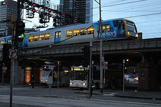
Transport in Melbourne, the state capital of Victoria, Australia, consists of several interlinking modes. Melbourne is a hub for intercity, intracity and regional travel. Road-based transport accounts for most trips across many parts of the city, facilitated by Australia's largest freeway network. Public transport, including the world's largest tram network, trains and buses, also forms a key part of the transport system. Other dominant modes include walking, cycling and commercial-passenger vehicle services such as taxis.
Flemington Road is a major thoroughfare in the inner suburbs of North Melbourne and Parkville in Melbourne, Victoria, Australia. It runs for 2 km in a northwest–southeast direction, from the southern end of Mount Alexander Road, Flemington, to Haymarket roundabout and the northern end of Elizabeth Street, and provides a main connection between the northern arm of the CityLink tollway and Melbourne's CBD.

Chandler Highway is a short road in the inner eastern suburbs of Melbourne, connecting Alphington over the Yarra River and Eastern Freeway to Kew. Its total length is less than 2 kilometres, leading to the claim that it is "the shortest highway in the world". It was named after a prominent local businessman and politician A. E. Chandler, who was instrumental in pushing through the development of the Outer Circle railway.

The Mooney Mooney Bridge, officially the Mooney Mooney Creek Bridge, and popularly known as The NSW Big Dipper Bridge, is a twin cantilever bridge that carries the Pacific Motorway (M1) across Mooney Mooney Creek, located near Mooney Mooney in the Brisbane Water National Park on the Central Coast of New South Wales, Australia. The concrete box girder bridge was opened on 14 December 1986 by the Prime Minister of Australia, Bob Hawke, and is owned and maintained by Transport for NSW, an agency of the Government of New South Wales.

Docklands Highway is an urban highway stretching 12 kilometres from Brooklyn in Melbourne's inner western suburbs to the Docklands precinct, adjacent to the city. This name covers many consecutive streets and is not widely known to most drivers, as the entire allocation is still best known as by the names of its constituent parts: Francis Street, Whitehall Street, Moreland Street, Napier Street, Footscray Road, Dudley Street and Wurundjeri Way. This article will deal with the entire length of the corridor for sake of completion, as well to avoid confusion between declarations.

The Church Street Bridge is an historic road arch bridge over the Yarra River and the Monash Freeway in Melbourne, Victoria, Australia. It links Church Street in Richmond on the north bank with Chapel Street in South Yarra on the south.

The Main Yarra Trail, also known as the Yarra Trail is a shared-use path for cyclists and pedestrians, which follows the Yarra River through the northeastern suburbs of Melbourne, Victoria, Australia.

South Wharf is an inner-city suburb in Melbourne, Victoria, Australia, 2 km south-west of Melbourne's Central Business District, located within the City of Melbourne local government area. South Wharf recorded a population of 71 at the 2021 census.
The following outline is provided as an overview of and topical guide to Melbourne: