Main Yarra Trail

Last updated

Yarra Trail
Yarra River from Kanes Bridge.JPG
The Yarra River, as seen from Kanes Bridge, near the Studley Park boathouse.
LengthAbout 38km from Princes Bridge to Mullum Mullum Creek Trail
Location Melbourne, Victoria, Australia
DifficultyEasy to medium
Hazards Some blind corners, steep drop into river. In winter, on the north bank near the city, ice can form on the floating pontoons. Steep corkscrew path used to cross under Banksia St.
Surface Mostly Concrete & bitumen path, well formed gravel along river flats.
HillsGipps Street steps. Bumpy metal joints and slippery ramps on Northbank promenade
WaterRegular water fountains in lower reaches, tap at "Yarra Marsh" (Heidelberg)
Train(s) Flinders Street, Clifton Hill, Heidelberg and Eltham (see Diamond Creek Trail)

The Main Yarra Trail, also known as the Yarra Trail is a shared-use path for cyclists and pedestrians, which follows the Yarra River through the northeastern suburbs of Melbourne, Victoria, Australia. [1] [2]

Contents

The trail follows the river from near its mouth, through the city and suburbs to Westerfolds Park and Eltham. The Capital City Trail uses the same path up to Dights Falls, where it continues up the Merri Creek Trail as part of its loop around the city. [3]

Following the Path

The path starts just to the north of West Gate Bridge near the mouth of the Yarra River as it enters Port Phillip Bay by the punt landing, allowing cyclists and pedestrians to cross to Spotswood and the Hobsons Bay Coastal Trail. [4]

From the punt landing, the trail winds through Melbourne Docklands, initially as a dedicated path on Lorimer Street and then, east of Todd Road it continues as an on-road cycling lane along Lorimer Street.

At the west side of Yarra's Edge and before the Docklands Highway, it heads off the road towards the bank of the river. The trail can be picked up at the southern end of the "Koori Eel Trap" footbridge, where it intersects with the Capital City Trail.

The trail passes the north side of the Melbourne Convention & Exhibition Centre, the Crown Casino and the restaurant sector of Southbank on a shared and often busy pedestrian boulevard with views of the Melbourne CBD across the Yarra River.

At the pedestrian bridge at Southbank pedestrians and cyclists may choose the trail under Princes Bridge to Flinders Street station, on the north side of the river, or the path can be followed along the south side.

On the north side of the river the trail passes Federation Square, the newly established riverside park of Birrarung Marr, Melbourne Park, and the Melbourne Cricket Ground. On the south side the trail passes several rowing clubs. It also passes the Royal Botanic Gardens and Como House nearby. At MacRobertson Bridge the paths meet on the north side of the river.

Continuing in Richmond the path meets up with the Gardiners Creek Trail. After going under the Victoria street bridge in Abbotsford the path reaches the Walmer Street shared pedestrian and cycle bridge.

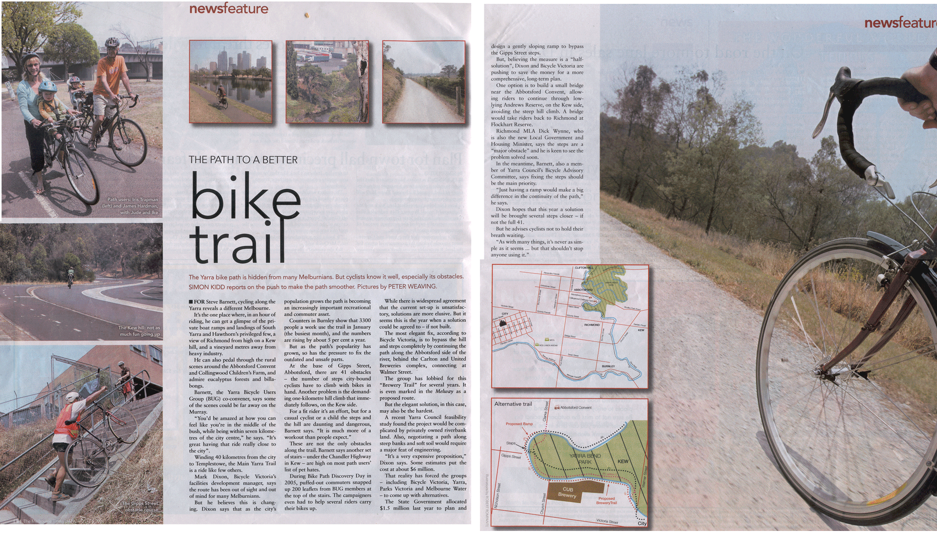
Once across the bridge on the north side of the river, the trail continues up a short steep hill to the base of Walmer St, and turns immediately to the left (west) into the park. The path continues until it reaches Yarra Boulevard, where the path descends to cross the Yarra River again at the Gipps Street shared pedestrian and cycle bridge. Alternatively, cyclists and pedestrians can continue to follow the Yarra Boulevard to Studley Park.

At Gipps Street, flights of steps connect to the concrete path on the western side of the river. Some cyclists choose to avoid the steps and ride the back streets of Abbotsford to meet the trail at the Collingwood Children's Farm.

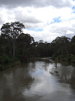
A short way further the trail comes to Dights Falls, an ancient meeting place for the Wurundjeri people and tribes of the Kulin nation. The weir and water race were used to power the Ceres flour mill that was once located here. Here the Capital City Trail follows the Merri Creek Trail up the Merri Creek. The Yarra River Trail crosses the Merri Creek there, then passes under the Eastern Freeway and starts a long gradual up hill climb to Melbourne Polytechnic, before crossing the Yarra river at the pedestrian Pipe bridge at the Fairfield boathouse. The bridge is narrow. On the eastern side of the river the path climbs steeply to Yarra Boulevard.

Fairfield boathouse Fairfield boathouse.jpg
Fairfield boathouse
Fairfield Pipe Bridge in Yarra Park Fairfield Pipe Bridge 2009.JPG
Fairfield Pipe Bridge in Yarra Park

An alternative to the Yarra River Trail at Yarra Bend Park is to follow the Yarra Boulevard as it continues through the parkland of Yarra Bend following the river. It is a tourist drive with on-road cycling lanes, which provides access to the Studley Park boathouse, where row boats can be hired. After crossing the Eastern Freeway the road climbs up a hill where it meets the Yarra Trail again.

From the top of the hill follow the Yarra boulevard down to the Chandler Highway. A ramped connecting path leads under the main road and to the Yarra path, next to the National Guide Dog and Mobility Centre.

The northern end of the Anniversary Outer Circle Trail is 0.6km from this point. The trail heads south on the Chandler Highway. The Anniversary Trail is just across the bridge that crosses the Eastern Freeway. A safer alternative is to continue 1.5km along the Yarra River Trail from the Chandler Highway to Willsmere Park. At Willsmere Park there is a crossing under the Eastern Freeway to a traverse to the Anniversary Trail via Hyde Park.

The Yarra River Trail tracks along the northern edge of the Eastern Freeway with first the La Trobe golf Club to the south over the river followed by the Kew Golf Club directly to the south. The Yarra River is rejoined near Burke Road. The trail crosses over a footbridge to the north side of the Yarra, just before the trail passes beneath the Burke Road bridge across the Yarra and Eastern Freeway. If you travel straight ahead instead of turning left to cross the footbridge you will find yourself on the Koonung Creek Trail. From the footbridge you can also use a hilly path, including a usually quiet on-road section (along The Boulevard, East Ivanhoe), to access the Sparks Reserve end of the Darebin Creek Trail.

Continuing the path travels along various natural features, including river flats, sporting ovals, market gardens, and paddocks with horses. There are many paths to explore as you ride through Ivanhoe, Heidelberg, Lower Plenty and Templestowe to Westerfolds Park.

On the way to Westerfolds Park, there are turnoffs to the River Gum Walk Trail, the Plenty River Trail and the Ruffey Creek Trail.

Topdown perspective of Ruffey Trail bridge between Westerfolds and Wombat Bend Park. Shot December 2018. Topdown perspective of Ruffey Trail suspension bridge.jpg
Topdown perspective of Ruffey Trail bridge between Westerfolds and Wombat Bend Park. Shot December 2018.

The southern section of the River Gum Walk Trail can easily be mistaken for the continuation of the Yarra River Trail. People coming from the south (from the City Centre) along the Yarra River Trail should turn right (east) 130m after crossing the canal at the end of Plymouth St, near the Banyule Tennis centre.

From the northeast corner of Westerfolds Park, the path continues up the Yarra River 1km to Candlebark Park. Across the long footbridge at Candlebark Park gives access to the Diamond Creek Trail. This intersection is unsigned except for some instructions relating to the usage of the park.

The Yarra trail continues to follow the river past Petty's Orchards and finally ends at the confluence of the Mullum Mullum Creek and the Yarra River in Templestowe. A lookout surveys the spot. The Mullum Mullum Creek Trail starts here leading to points further afield. However, an extension to the Yarra Trail is currently being constructed, which will extend the path to Warrandyte, via Heidelberg-Warrandyte Road and Taroona Avenue.

Landmarks

Yarra River, Docklands, Southbank, Yarra Bend Park, Collingwood Children's Farm, Westerfolds Park.

Connections

The trail leads to numerous other trails. Going from west to east: Capital City Trail, Sandridge Trail, Gardiners Creek Trail, Merri Creek Trail, Anniversary Trail, Darebin Creek Trail, Koonung Creek Trail, River Gum Walk Trail, Plenty River Trail, Ruffey Creek Trail, Diamond Creek Trail and lower Mullum Mullum Creek Trail.

West end at 37°49′45″S144°54′03″E / 37.829302°S 144.900715°E / -37.829302; 144.900715 . East end at 37°44′18″S145°09′43″E / 37.738386°S 145.161994°E / -37.738386; 145.161994 .

See also

Related Research Articles

<span class="mw-page-title-main">Abbotsford, Victoria</span> Suburb of Melbourne, Victoria, Australia

Abbotsford is an inner-city suburb in Melbourne, Victoria, Australia, 2 km (1.2 mi) north-east of Melbourne's Central Business District, located within the City of Yarra local government area. Abbotsford recorded a population of 9,088 at the 2021 census.

<span class="mw-page-title-main">Moonee Ponds Creek Trail</span>

The Moonee Ponds Creek Trail is a shared use path for cyclists and pedestrians, which follows the Moonee Ponds Creek through the northern suburbs of Melbourne, Victoria, Australia.

<span class="mw-page-title-main">Capital City Trail</span>

The Capital City Trail is a shared use path in Melbourne, Victoria, Australia, which circles the city centre and some inner eastern and northern suburbs. It is 29km in length, and mostly consists of sections of other trails, such as the Merri Creek Trail, Main Yarra Trail, Moonee Ponds Creek Trail and Inner Circle Rail Trail.

<span class="mw-page-title-main">Maribyrnong River Trail</span>

The Maribyrnong River Trail is a shared use path for cyclists and pedestrians, which follows the Maribyrnong River through the north western suburbs of Melbourne, Victoria, Australia.

<span class="mw-page-title-main">Diamond Creek Trail</span> Path that follows the creek in Melbourne, Victoria, Australia

The Diamond Creek Trail is a shared use path for cyclists and pedestrians, which follows Diamond Creek through the north eastern outer suburbs of Melbourne, Victoria, Australia.

<span class="mw-page-title-main">Merri Creek Trail</span>

The Merri Creek Trail is a shared use path for cyclists and pedestrians that follows the Merri Creek through the northern suburbs of Melbourne, Victoria, Australia.

<span class="mw-page-title-main">Westerfolds Park</span> Park in Templestowe, Melbourne, Victoria, Australia

Westerfolds Park is a metropolitan park situated in Templestowe, an eastern suburb of Melbourne, Australia.

<span class="mw-page-title-main">Mullum Mullum Creek</span> Creek in Victoria, Australia

Mullum Mullum Creek is a creek in the outer eastern suburbs of Melbourne, Victoria, Australia. It is the main watercourse of the Mullum Mullum Valley, a tributary of the Yarra River and Yarra Valley. For tens of thousands of years it was used as a food and tool source sustainably by the Wurundjeri people, Indigenous Australians of the Kulin nation, who spoke variations of the Woiwurrung language group.

<span class="mw-page-title-main">Gardiners Creek Trail</span>

The Gardiners Creek Trail is a shared use path for cyclists and pedestrians, which follows Gardiners Creek through the eastern suburbs of Melbourne, Victoria, Australia.

<span class="mw-page-title-main">Koonung Creek</span> River in Victoria, Australia

Koonung Creek is a small tributary of the Yarra River in Melbourne's east. The creek originates in Nunawading near Springvale Road, and flows to join the Yarra at the border between Ivanhoe East, Bulleen and Balwyn North. The place the two waterways meet forms the borders between these suburbs. Bushy Creek is a tributary to the creek, joining near Elgar Park in Mont Albert North. A shared use path follows the course of the creek, known as the Koonung Creek Trail.

<span class="mw-page-title-main">Gardiners Creek</span> River in Victoria, Australia

Gardiners Creek, originally known as Kooyongkoot Creek, is an urban stream in the eastern suburbs of Melbourne, and part of the Yarra River catchment.

<span class="mw-page-title-main">Chandler Highway</span>

The Chandler Highway is a short road in the inner eastern suburbs of Melbourne. It runs from Heidelberg Road in Alphington, crosses the Yarra River, then continues across the Eastern Freeway, then terminates at an intersection with Princess Street and Earl Street. Its total length is less than 2 kilometres, leading to the claim that it is "the shortest highway in the world". It was named after a prominent local businessman and politician A. E. Chandler, who was instrumental in pushing through the development of the Outer Circle railway.

<span class="mw-page-title-main">Outer Circle Trail</span>

The Outer Circle Trail, also known as the Anniversary Trail, is a shared use path for cyclists and pedestrians, which partly follows the Alamein Line through the inner eastern suburbs of Melbourne, Victoria, Australia.

<span class="mw-page-title-main">Ringwood to Belgrave Rail Trail</span> Rail trail in Victoria, Australia

The Ringwood - Belgrave Rail Trail is a shared use path for cyclists and pedestrians, which follows the Belgrave railway line from the Mullum Mullum Creek Trail in Ringwood to Belgrave railway station in Belgrave, in the outer eastern suburbs of Melbourne, Victoria, Australia.

<span class="mw-page-title-main">Darebin Creek Trail</span>

The Darebin Creek Trail is a shared use path for cyclists and pedestrians which follows Darebin Creek in the inner and outer northern suburbs of Melbourne, Victoria, Australia.

<span class="mw-page-title-main">Craigieburn Bypass Trail</span>

The Craigieburn Bypass Trail, is a shared use path for cyclists and pedestrians in the outer northern suburbs of Melbourne, Victoria, Australia. In 2008 it was given the local name of the Galada Tamboore Pathway - Wurundjeri for "creek waterhole" or "stream waterhole" - as it goes past the Craigieburn, Cooper street and Galada Tamboore grasslands which are all nationally significant for their plains grassland and riparian habitat for endangered and vulnerable native fauna and flora, including the critically endangered Golden Sun Moth.

<span class="mw-page-title-main">Koonung Creek Trail</span>

The Koonung Creek Trail, also known as the Koonung Trail, is a shared use path for cyclists and pedestrians, which follows Koonung Creek in the eastern suburbs of Melbourne, Victoria, Australia. The trail also follows the course of the Eastern Freeway as it too, follows the course of the Koonung Creek, and has good connections to on-road paths.

<span class="mw-page-title-main">Mullum Mullum Creek Trail</span>

The Mullum Mullum Creek Trail is a shared use path for cyclists and pedestrians, which follows Mullum Mullum Creek in the outer eastern suburbs in Melbourne, Victoria, Australia.

The Ruffey Creek Trail is a shared use path for cyclists and pedestrians, which follows Ruffey Creek in the inner eastern suburbs of Templestowe and Doncaster in Melbourne, Victoria, Australia.

<span class="mw-page-title-main">Greensborough Bypass Trail</span>

The Greensborough Bypass Trail is a shared use path for cyclists and pedestrians which follows the Greensborough Bypass through the north-eastern suburbs of Melbourne, Australia. It was built in 2006 as part of works to build the new road across around the suburbs of Greensborough and Watsonia North. The trail is managed by VicRoads.

References

  1. VicRoads - Bicycle Facilities Map Archived 2007-02-19 at the Wayback Machine
  2. Melbourne and Geelong's shared paths in Google Earth
  3. "Walking tracks and bike paths | Melbourne Water". www.melbournewater.com.au. Retrieved 6 January 2023.
  4. "8 bike paths in Melbourne". Car Next Door Blog. 31 May 2019. Retrieved 20 July 2022.