Gardiners Creek Trail

Last updated

Gardiners Creek Trail
GardinersCreek+Trail-GardinersReserve.jpg
Gardiners Creek and Trail in Gardiners Reserve, Burwood
LengthApprox 17 km
Location Melbourne, Victoria, Australia
Cycling details
Trail difficultyMostly easy
Hazards Can be very crowded
Surface Bitumen
HillsMostly flat
WaterWater fountains at several locations
Connecting transport
Train(s) Kooyong, East Malvern and Blackburn Stations

The Gardiners Creek Trail is a shared use path for cyclists and pedestrians, which follows Gardiners Creek through the eastern suburbs of Melbourne, Victoria, Australia. [1] [2] [3] [4]

Contents

Bicycle Victoria is campaigning for a connection between Winton Road and Warrigal Road, to complete the gap in the trail at this point. It is proposed that the path would continue along the creek parallel to the Malvern Public Golf Course, spanning the gap from Winton Road to Warrigal Road.

Following the path

The Solway Street Bridge before it was swept away by flood waters SolwayStFootBridge,EastMalvern.jpg
The Solway Street Bridge before it was swept away by flood waters

The path begins as a branch of the Main Yarra Trail, opposite St Kevin's College and Scotch College, close to Kooyong railway station (on the Glen Waverley line); between the suburbs of Toorak, Hawthorn, and Kooyong. The path snakes along Gardiners Creek, near the Monash Freeway. It also goes past Solway Primary School.

Near Malvern East railway station it crosses Winton Road, and shortly after this point the path diverts. The branch to the right leads to a bridge over the Monash Freeway and railway line, giving access to Malvern East railway station or continuing on to pick up the Scotchmans Creek Trail and Malvern East Station to Centre Rd Trail. The main Gardiners Creek Trail continues to the left, crossing the Solway Street Bridge that was rebuilt and opened in late 2011 after being washed away by flood waters in February 2011. Over the bridge the path continues through a small parkland ending on Ryburne Avenue opposite the very southern end of the Anniversary Trail.

To re-access the Gardiners Creek Trail riders can either follow Ryburne Ave and Ashburn Grove to Markham Road, or take the Anniversary Trail almost to Alamein station, where another trail splits off to the right and rejoins the Gardiners Creek Trail at Markham Road. The trail then continues via Markham Reserve to Warrigal Road. An underpass of Warrigal Road, completed in August 2011, now allows easy access to the path on the east side of Warrigal Road, at the north side of the creek.

The path continues northeast through Ashwood Reserve to High Street Road, which crossed with the aid of a small traffic island, and then north (near Ashwood College) near Gardiners Reserve to Highbury Road. A pedestrian crossing passes over the road, and after crossing the creek on the road bridge the path continues north through Local History Park in Burwood to the intersection of McIntyre Street, Elgar Road, and Burwood Highway, near Presbyterian Ladies' College and the Burwood Campus of Deakin University.

Aerial perspective of Gardiners Creek and trail cutting across the Deakin University Burwood campus. Shot September 2018. Altitutude: 110m. Deakin University Burwood Campus Aerial Panorama.jpg
Aerial perspective of Gardiners Creek and trail cutting across the Deakin University Burwood campus. Shot September 2018. Altitutude: 110m.

From Burwood Highway the path continues north-east alongside Deakin University through Gardiners Creek Reserve to Station Street, near the Box Hill Golf Club. Riders have the choice of taking an unsealed, though well made, trail on either side of the creek through Gardiners Creek Reserve; this remains one of the few remaining unsealed sections along the entire trail, but is also one of the few sections with paths on both sides of the creek. Once at Station Street riders can detour to a nearby pedestrian crossing, or cross at the lights at Riversdale Road.

Riders may choose to divert to the Wurundjeri Walk Trail at this point by heading up Boardman Close on the east side of Station St, with the far end of the close leading to the Wurundjeri Walk Trail. To remain on the Gardiners Creek Trail, riders should travel north up Old Station Street, passing immediately by the main golf club entrance, and then turn right at the quiet and dead end part of Riversdale Road. If crossing at the Riversdale Road lights riders can simply continue straight ahead along Riversdale Road. The trail resumes at the end of Riversdale Road alongside the carpark of the golf club. Regardless of which route is being taken beyond Station Street, trail signage in this area is virtually non-existent, and great care needs to be taken to avoid getting lost.

The Gardiners Creek Trail continues north east, via a path on the north side of the Box Hill Golf Course, to the intersection of Canterbury and Middleborough Roads in Box Hill South. It then travels on a shared bicycle/footpath beside Middleborough Road past R.H.L. Sparks Reserve and ends at a pedestrian crossing near Albion Road. Across the road, a pedestrian path, which can be used by cyclists, continues east through the Blackburn Creeklands - through Blacks Walk, Kalang Park and Furness Park to Blackburn Road; the path is unsealed through this section so slower speeds are advised.

Across Blackburn Road riders can use either Alandale Road or Jeffrey Street to enter Blackburn Lake Sanctuary. North of here is Blackburn Station and Blackburn shopping centre.

Gardiners Creek Trail map Stevage.png

Solway Street bridge

The Solway Street Bridge after it was swept away by flood waters SolwayStFootBridge,EastMalvernDestoyed.jpg
The Solway Street Bridge after it was swept away by flood waters

The old Solway Street footbridge was closed due to storm damage, sometime before April 2006. The bridge was shored up and reopened in June 2007, even though a replacement bridge had been proposed since at least 2003. [5] [6] [7] As of April 2008 it remained just a proposal. [8] [9] [10]

The old bridge was finally washed away by flood waters very early in the morning of 5 February 2011, after heavy rain resulting from the remnants of Tropical Cyclone Yasi, rendering the bridge impassable. During the later half of 2011 the bridge was completely replaced and was opened to the Public unofficially on 22 December 2011.

Connections

The westernmost end of the trail meets the Capital City Trail/Yarra River Trail at the Yarra River. Centrally it connects with the Anniversary Trail, which runs along the Alamein railway line and to the nearby Scotchmans Creek Trail and East Malvern Station to Centre Rd Trail at East Malvern railway station. At Warrigal Road it connects to the Waverley Rail Trail. Towards the easternmost end it meets the Wurundjeri Walk Trail in Blackburn South, and finally ends at the corner of Albion Road and Middleborough Road opposite Blacks Walk (part of the Blackburn Creeklands) in Blackburn.

The Ferndale Park Trail acts as a short cut to the Anniversary Trail.

Note the footbridge over the Monash Freeway was reopened on 20 August 2009. [11]

West end at 37°50′02″S145°01′25″E / 37.833995°S 145.023586°E / -37.833995; 145.023586 . East end at 37°49′33″S145°08′14″E / 37.825950°S 145.137131°E / -37.825950; 145.137131 .

Related Research Articles

City of Boroondara Local government area in Victoria, Australia

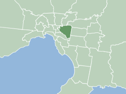
The City of Boroondara is a local government area in Victoria, Australia. It is located in the eastern suburbs of Melbourne. It was formed in June 1994 from the amalgamation of the Cities of Kew, Camberwell and Hawthorn.

Box Hill South, Victoria Suburb of Melbourne, Victoria, Australia

Box Hill South is a suburb of Melbourne, Victoria, Australia, 14 km east of Melbourne's Central Business District. Its local government area is the City of Whitehorse. At the 2016 Census, Box Hill South had a population of 8,434.

Burwood, Victoria Suburb of Melbourne, Victoria, Australia

Burwood is a suburb of Melbourne, Victoria, Australia, 14 km east of Melbourne's Central Business District. Its local government areas are the Cities of Monash and Whitehorse. At the 2016 Census, Burwood had a population of 15,019.

Ashburton, Victoria Suburb of Melbourne, Victoria, Australia

Ashburton is a suburb of Melbourne, Victoria, Australia, 12 km (7.5 mi) southeast of Melbourne's Central Business District. Its local government area is the City of Boroondara. At the 2016 census, Ashburton had a population of 7,751.

Melbourne tram route 75

Melbourne tram route 75 is operated by Yarra Trams on the Melbourne tram network. It operates from Vermont South to Central Pier, Docklands, serviced by A and B class trams from Camberwell depot. At 22.8 kilometres, it is currently the longest line in the network.

Dandenong Creek Trail

The Dandenong Creek Trail is a shared use path for cyclists and pedestrians, which follows Dandenong Creek through the outer eastern and south-eastern suburbs of Melbourne, Victoria, Australia.

Gardiners Creek

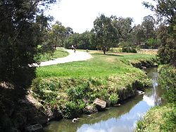
Gardiners Creek, originally known as Kooyongkoot Creek, is a waterway in the eastern suburbs of Melbourne, and part of the Yarra River catchment.

Outer Circle Trail

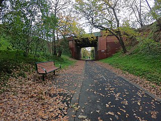
The Outer Circle Trail, also known as the Anniversary Trail, Anniversary Outer Circle Trail, or even the Outer Circle Anniversary Trail, is a shared use path for cyclists and pedestrians, which partly follows the Alamein Line through the inner eastern suburbs of Melbourne, Victoria, Australia.

Scotchmans Creek Trail

The Scotchmans Creek Trail is a shared use path for cyclists and pedestrians, which follows Scotchmans Creek through the eastern suburbs of Melbourne, Victoria, Australia.

Blind Creek Trail

The Blind Creek Trail, in the outer eastern suburbs of Melbourne, in the Australian state of Victoria, is a shared-use path for cyclists and pedestrians, which follows the Blind Creek from the Dandenong Creek Trail in Wantirna South to the Ringwood - Belgrave Rail Trail in Boronia.

Ringwood–Belgrave Rail Trail

The Ringwood - Belgrave Rail Trail is a shared use path for cyclists and pedestrians, which follows the Belgrave railway line from the Mullum Mullum Creek Trail in Ringwood to Belgrave railway station in Belgrave, in the outer eastern suburbs of Melbourne, Victoria, Australia.

Bushy Creek Trail

The Bushy Creek Trail is a shared use path for cyclists and pedestrians in the inner eastern suburb of Box Hill North in Melbourne, Victoria, Australia.

Darebin Creek Trail

The Darebin Creek Trail is a shared use path for cyclists and pedestrians which follows Darebin Creek in the inner and outer northern suburbs of Melbourne, Victoria, Australia.

The Ferndale Park Trail is a shared use path for cyclists and pedestrians in the suburb of Glen Iris, an inner eastern suburb of Melbourne, Victoria.

Koonung Creek Trail

The Koonung Creek Trail is a shared use path for cyclists and pedestrians, which follows Koonung Creek in the eastern suburbs of Melbourne, Victoria, Australia. The trail also follows the course of the Eastern Freeway as it too, follows the course of the Koonung Creek, and has good connections to on-road paths.

The Wurundjeri Walk Trail is a shared use path for cyclists and pedestrians in the inner eastern suburbs of Blackburn South and Forest Hill in Melbourne, Victoria, Australia.

Syndal Heatherdale Pipe Reserve Trail

The Syndal Heatherdale Pipe Reserve Trail is a shared use path for cyclists and pedestrians, which follows the Syndal to Heatherdale pipe reserve in the eastern suburbs of Melbourne, Victoria, Australia.

Waverley Rail Trail

The Waverley Rail Trail is a combination of shared use path for cyclists and pedestrians and on-road bicycle route, which follows the Glen Waverley railway line from Holmesglen railway station to Glen Waverley railway station in the south eastern suburbs of Melbourne, Victoria, Australia.

Main Yarra Trail

The Yarra Trail is a shared use path for cyclists and pedestrians, which follows the Yarra River through the north eastern suburbs of Melbourne, Victoria, Australia.

The Box Hill to Ringwood Rail Trail is a shared use path that runs alongside the Belgrave and Lilydale Lines in the east of Melbourne, Australia. The route serves a total of seven railway stations. The bike path is incomplete, as the section between Blackburn and Laburnum is yet to be constructed.

References