Related Research Articles

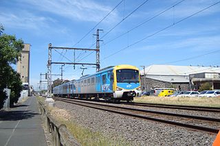
Melton is an urban area within metropolitan Melbourne, Australia located 35 km west from the capital's central business district. It is the administrative centre of the City of Melton local government area and its most populous centre. At June 2018 Melton had an estimated urban population of 68,765, and has grown steadily with an average annual rate of 4.88% year-on-year for the five years to 2018. It is considered part of the Greater Melbourne metropolitan area and is included in the capital's population statistical division.

Melton South is a suburb of Melbourne, Victoria, Australia, 37 km west of Melbourne's Central Business District, located within the City of Melton local government area. Melton South recorded a population of 11,517 at the 2016 Census.
The Upfield Shared Path is a shared use path for cyclists and pedestrians, which follows Upfield railway line through the inner northern suburbs of Melbourne, Victoria, Australia.

The Moonee Ponds Creek Trail is a shared use path for cyclists and pedestrians, which follows the Moonee Ponds Creek through the northern suburbs of Melbourne, Victoria, Australia.

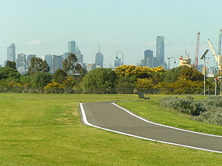
The Capital City Trail is a shared use path in Melbourne, Victoria, Australia, which circles the city centre and some inner eastern and northern suburbs. It is 29km in length, and mostly consists of sections of other trails, such as the Merri Creek Trail, Main Yarra Trail, Moonee Ponds Creek Trail and Inner Circle Rail Trail.

The Maribyrnong River Trail is a shared use path for cyclists and pedestrians, which follows the Maribyrnong River through the north western suburbs of Melbourne, Victoria, Australia.

The Merri Creek Trail is a shared use path for cyclists and pedestrians that follows the Merri Creek through the northern suburbs of Melbourne, Victoria, Australia.

The Division of Gorton is an Australian Electoral Division in the state of Victoria.

Toolern Creek is a small tributary of the Werribee River in Victoria. The creek rises near Toolern Vale and flows through the Melbourne suburbs of Melton and Melton South, separating the industrial and residential areas of these suburbs.

The Broadmeadows Valley Trail is a shared use path for cyclists and pedestrians in the outer northern suburbs of Melbourne, Victoria, Australia.
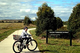
The Craigieburn Bypass Trail, is a shared use path for cyclists and pedestrians in the outer northern suburbs of Melbourne, Victoria, Australia. In 2008 it was given the local name of the Galada Tamboore Pathway - Wurundjeri for "creek waterhole" or "stream waterhole" - as it goes past the Craigieburn, Cooper street and Galada Tamboore grasslands which are all nationally significant for their plains grassland and riparian habitat for endangered and vulnerable native fauna and flora, including the critically endangered Golden Sun Moth.
The Hobsons Bay Coastal Trail is a shared use path for cyclists and pedestrians, which follows the coast line of Hobsons Bay in the inner western suburbs in Melbourne, Victoria, Australia. The trail forms part of the western half of the Bayside Trail which encircles Port Phillip. It runs from the west side of the Westgate bridge, south and along the coast, finishing at the Skeleton Creek Trail in Sanctuary Lakes.

The Kororoit Creek Trail is a shared use path for cyclists and pedestrians, which follows the Kororoit Creek in the inner western suburbs of Melbourne, Victoria, Australia.
The Laverton Creek Trail is a shared use path for cyclists and pedestrians, which follows Laverton Creek in the outer western suburbs of Laverton and Altona in Melbourne, Victoria, Australia.
The Skeleton Creek Trail is a shared use path for cyclists and pedestrians, which follows Skeleton Creek as it passes through the outer south western suburbs of Point Cook and Altona Meadows in Melbourne, Victoria, Australia.
The Steele Creek Trail is a shared use path for cyclists and pedestrians, which follows Steele Creek in the Outer North Western suburbs of Keilor Park, Keilor East, Tullamarine, Airport West, Melbourne Airport, Avondale heights, Essendon West and Niddrie in Melbourne.
The Werribee River Trail is a shared use path for cyclists and pedestrians, which follows Werribee River in the outer western suburb of Werribee in Melbourne, Victoria, Australia.
The Western Ring Road Trail is a shared use path for cyclists and pedestrians that bridges the northern suburbs and follows the Western Ring Road freeway in Melbourne, Australia. It intercepts many other paths making possible a large variety of circuits for the recreational cyclist.
The Taylors Creek Trail is a shared use path for cyclists and pedestrians, which follows Taylors Creek in the outer north suburb of Taylors Lakes in Melbourne, Victoria, Australia.

Cobblebank is a developing outer suburb located 31km west of the CBD of Melbourne, Victoria, Australia. Its local government area is the City of Melton. The suburb was gazetted by the Office of Geographic Names on 9 February 2017, following a proposal for eleven new suburbs by the City of Melton. The new name officially came into effect in mid-2017. Prior to the suburb's creation, the area was part of Melton South.
References
- ↑ VicRoads - Bicycle Facilities Map Archived 2007-02-19 at the Wayback Machine