Related Research Articles

The Moonee Ponds Creek Trail is a shared use path for cyclists and pedestrians, which follows the Moonee Ponds Creek through the northern suburbs of Melbourne, Victoria, Australia.

The Merri Creek Trail is a shared use path for cyclists and pedestrians that follows the Merri Creek through the northern suburbs of Melbourne, Victoria, Australia.

The Blind Creek Trail, in the outer eastern suburbs of Melbourne, in the Australian state of Victoria, is a shared-use path for cyclists and pedestrians, which follows the Blind Creek from the Dandenong Creek Trail in Wantirna South to the Ringwood - Belgrave Rail Trail in Boronia.

The Bushy Creek Trail is a shared use path for cyclists and pedestrians in the inner eastern suburb of Box Hill North in Melbourne, Victoria, Australia.

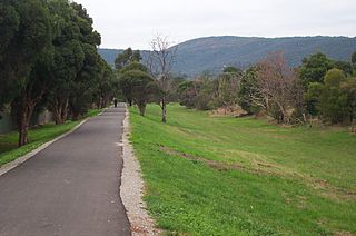
The Darebin Creek Trail is a shared use path for cyclists and pedestrians which follows Darebin Creek in the inner and outer northern suburbs of Melbourne, Victoria, Australia.
The Ferndale Park Trail is a shared use path for cyclists and pedestrians in the suburb of Glen Iris, an inner eastern suburb of Melbourne, Victoria.
The Ferny Creek Trail is a shared use path for cyclists and pedestrians, which follows Ferny and Corhanwarrabul Creeks through the suburbs of Knoxfield and Ferntree Gully in Melbourne, Victoria, Australia.
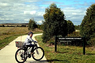
The Craigieburn Bypass Trail, is a shared use path for cyclists and pedestrians in the outer northern suburbs of Melbourne, Victoria, Australia. In 2008 it was given the local name of the Galada Tamboore Pathway - Wurundjeri for "creek waterhole" or "stream waterhole" - as it goes past the Craigieburn, Cooper street and Galada Tamboore grasslands which are all nationally significant for their plains grassland and riparian habitat for endangered and vulnerable native fauna and flora, including the critically endangered Golden Sun Moth.
The Greengully Trail is a shared use path for cyclists and pedestrians in the inner eastern suburb of Templestowe in Melbourne, Victoria, Australia.

The Koonung Creek Trail, also known as the Koonung Trail, is a shared use path for cyclists and pedestrians, which follows Koonung Creek in the eastern suburbs of Melbourne, Victoria, Australia. The trail also follows the course of the Eastern Freeway as it too, follows the course of the Koonung Creek, and has good connections to on-road paths.

The Kororoit Creek Trail is a shared use path for cyclists and pedestrians, which follows the Kororoit Creek in the inner western suburbs of Melbourne, Victoria, Australia.

The River Gum Walk Trail is a shared use path for cyclists and pedestrians in the suburb of Rosanna, an inner northern suburb of Melbourne, Victoria, Australia.
The Plenty River Trail is a shared use path for cyclists and pedestrians, which follows the Plenty River through the suburbs of Greensborough and Lower Plenty in Melbourne, Victoria, Australia.
The Ruffey Creek Trail is a shared use path for cyclists and pedestrians, which follows Ruffey Creek in the inner eastern suburbs of Templestowe and Doncaster in Melbourne, Victoria, Australia.
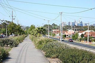
The Northern Pipe Trail, is a shared-use path for cyclists and pedestrians that follows Cheddar and St Georges Roads in the northern suburbs of Reservoir, Preston and Thornbury in Melbourne, Victoria, Australia.
The Tarralla Creek Trail is a shared use path for cyclists and pedestrians, which follows Tarralla Creek, in the outer eastern suburb of Croydon in Melbourne, Victoria, Australia. It is part of the Carrum to Warburton trail and Bayswater to Lilydale link.
The Werribee River Trail is a shared use path for cyclists and pedestrians, which follows Werribee River in the outer western suburb of Werribee in Melbourne, Victoria, Australia.

The M80 Trail is a shared-use path for cyclists and pedestrians that bridges the northern suburbs and follows the Western Ring Road/Metropolitan Ring Road (M80) freeway in Melbourne, Australia.

The Syndal Heatherdale Pipe Reserve Trail is a shared use path for cyclists and pedestrians, which follows the Syndal to Heatherdale pipe reserve in the eastern suburbs of Melbourne, Victoria, Australia.
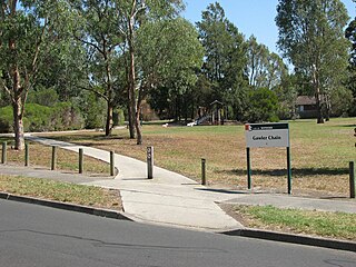
The Gawler Chain Trail is a shared use path for cyclists and pedestrians in the inner eastern suburb of Mont Albert in Melbourne, Victoria, Australia.
References
 Geographic data related to Edgars Creek Trail at OpenStreetMap
- ↑ VicRoads - Bicycle Facilities Map Archived February 19, 2007, at the Wayback Machine
- ↑ Melbourne and Geelong's shared paths in Google Maps
- ↑ "Melbourne and Geelong's shared paths in Google Earth". Archived from the original on 12 October 2016. Retrieved 13 June 2007.
| | This cycling-related article is a stub. You can help Wikipedia by expanding it. |
| | This Melbourne-related article is a stub. You can help Wikipedia by expanding it. |