Greensborough Bypass Trail

Last updated

Greensborough Bypass Trail
Greensborough Bypass Path, Watsonia North (31717957010).jpg
The Trail passing through Watsonia North.
Length4.1km
Location Melbourne, Victoria, Australia
Cycling details
Trail difficultyEasy
Surface Concrete and bitumen
HillsSome hilly sections
WaterNone
Connecting transport
Train(s)None

The Greensborough Bypass Trail is a shared use path for cyclists and pedestrians which follows the Greensborough Bypass through the north-eastern suburbs of Melbourne, Australia. It was built in 2006 as part of works to build the new road across around the suburbs of Greensborough and Watsonia North. [1] [2] The trail is managed by VicRoads. [3]

Shared use path form of infrastructure that supports multiple recreation and transportation opportunities, such as walking, bicycling, inline skating and people in wheelchairs

A shared-use path or mixed-use path is a form of infrastructure that supports multiple recreation and transportation opportunities, such as walking, bicycling, inline skating and people in wheelchairs. Motorcycles and mopeds are normally prohibited. A shared-use path typically has a surface that is asphalt, concrete or firmly packed crushed aggregate. In the U.S., the 1999 AASHTO Guide for the Development of Bicycle Facilities defines a shared-use path as being physically separated from motor vehicular traffic with an open space or barrier. Shared-use paths differ from exclusive bikeways in that shared-use paths are designed to include pedestrians even if the primary anticipated users are cyclists. Some shared paths have been built as rail trails.

Cycling riding a bicycle

Cycling, also called biking or bicycling, is the use of bicycles for transport, recreation, exercise or sport. People engaged in cycling are referred to as "cyclists", "bikers", or less commonly, as "bicyclists". Apart from two-wheeled bicycles, "cycling" also includes the riding of unicycles, tricycles, quadracycles, recumbent and similar human-powered vehicles (HPVs).

Pedestrian person traveling on foot

A pedestrian is a person travelling on foot, whether walking or running. In modern times, the term usually refers to someone walking on a road or pavement, but this was not the case historically.

Contents

Following the path

The path starts at Grimshaw Street in Greensborough near the intersection with the Greensborough Bypass. It then follows the road north running along its eastern side. After crossing Kempston Street, which can be used to visit the Kalparrin Gardens, the path begins tending uphill.

After a gradual turn to the east and a moderately steep incline near Banfield Terrace, the path reaches the Plenty River and turns north underneath the Greensborough Bypass bridge to connect to the Western Ring Road Trail.

Plenty River (Victoria) river in Victoria, Australia

The Plenty River is a perennial river of the Port Phillip catchment, located in the south-eastern Greater Melbourne region of the Australian state of Victoria.

The Western Ring Road Trail is a shared use path for cyclists and pedestrians that bridges the northern suburbs and follows the Western Ring Road freeway in Melbourne, Australia. It intercepts many other paths making possible a large variety of circuits for the recreational cyclist.

Connections

The only connection to an existing off-road trail exists to the north where the path connects with the Western Ring Road Trail. No connection exists to the south. While some lobbying by cyclists occurred to rectify this southern path in 2012, no progress has been made to date. [1]

Related Research Articles

Moonee Ponds Creek Trail shared use path following the Moonee Ponds Creek in Melbourne, Victoria, Australia

The Moonee Ponds Creek Trail is a shared use path for cyclists and pedestrians, which follows the Moonee Ponds Creek through the northern suburbs of Melbourne, Victoria, Australia.

Maribyrnong River Trail

The Maribyrnong River Trail is a shared use path for cyclists and pedestrians, which follows the Maribyrnong River through the north western suburbs of Melbourne, Victoria, Australia.

Merri Creek Trail

The Merri Creek Trail is a shared use path for cyclists and pedestrians that follows the Merri Creek through the northern suburbs of Melbourne, Victoria, Australia.

Gardiners Creek Trail

The Gardiners Creek Trail is a shared use path for cyclists and pedestrians, which follows Gardiners Creek through the eastern suburbs of Melbourne, Victoria, Australia.

Federation Trail shared use pedestrian/cycle path in western suburbs of Melbourne, Australia, following the line of a disused heritage-listed trunk sewer

The Federation Trail is a 23-kilometre-long (14 mi) shared use path for cyclists and pedestrians, which mainly follows the heritage-listed Main Outfall Sewer through the western suburbs of Melbourne, Victoria, Australia. There are button-activated traffic light crossings at most major road-trail intersections.

Outer Circle Trail

The Outer Circle Trail, also known as the Anniversary Trail, Anniversary Outer Circle Trail, or even the Outer Circle Anniversary Trail, is a shared use path for cyclists and pedestrians, which partly follows the Alamein Line through the inner eastern suburbs of Melbourne, Victoria, Australia.

Ringwood–Belgrave Rail Trail

The Ringwood - Belgrave Rail Trail is a shared use path for cyclists and pedestrians, which follows the Belgrave railway line from the Mullum Mullum Creek Trail in Ringwood to Belgrave railway station in Belgrave, in the outer eastern suburbs of Melbourne, Victoria, Australia.

Darebin Creek Trail

The Darebin Creek Trail is a shared use path for cyclists and pedestrians which follows Darebin Creek in the inner and outer northern suburbs of Melbourne, Victoria, Australia.

Craigieburn Bypass Trail

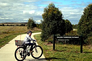
The Craigieburn Bypass Trail, is a shared use path for cyclists and pedestrians in the outer northern suburbs of Melbourne, Victoria, Australia. In 2008 it was given the local name of the Galada Tamboore Pathway - Wurundjeri for "creek waterhole" or "stream waterhole" - as it goes past the Craigieburn, Cooper street and Galada Tamboore grasslands which are all nationally significant for their plains grassland and riparian habitat for endangered and vulnerable native fauna and flora, including the critically endangered Golden Sun Moth.

The Hallam Bypass Trail is a shared use path for cyclists and pedestrians running along the Hallam Bypass between Doveton and Berwick in the outer eastern suburbs of Melbourne, Victoria, Australia. The trail was completed in 2003.

Koonung Creek Trail

The Koonung Creek Trail is a shared use path for cyclists and pedestrians, which follows Koonung Creek in the eastern suburbs of Melbourne, Victoria, Australia. The trail also follows the course of the Eastern Freeway as it too, follows the course of the Koonung Creek, and has good connections to on-road paths.

Mullum Mullum Creek Trail

The Mullum Mullum Creek Trail is a shared use path for cyclists and pedestrians, which follows Mullum Mullum Creek in the outer eastern suburbs in Melbourne, Victoria, Australia.

The River Gum Walk Trail is a shared use path for cyclists and pedestrians in the suburb of Rosanna, an inner northern suburb of Melbourne, Victoria, Australia.

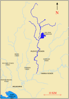
The Plenty River Trail is a shared use path for cyclists and pedestrians, which follows the Plenty River through the suburbs of Greensborough and Lower Plenty in Melbourne, Victoria, Australia.

The Station Trail is a shared use path for cyclists and pedestrians, which follows the Pakenham/Cranbourne railway lines from Hughesdale railway station to Centre Road, Clayton in the inner southern suburbs of Melbourne, Victoria, Australia.

Bay Trail shared use path for cyclists and pedestrians which follows the coastline of Port Phillip Bay through the south-eastern suburbs of Melbourne, Victoria, Australia

The Bay Trail is a shared use path for cyclists and pedestrians which follows the coastline of Port Phillip Bay through the south-eastern suburbs of Melbourne, Victoria, Australia.

Waverley Rail Trail

The Waverley Rail Trail is a combination of shared use path for cyclists and pedestrians and on-road bicycle route, which follows the Glen Waverley railway line from Holmesglen railway station to Glen Waverley railway station in the south eastern suburbs of Melbourne, Victoria, Australia.

Main Yarra Trail

The Yarra Trail is a shared use path for cyclists and pedestrians, which follows the Yarra River through the north eastern suburbs of Melbourne, Victoria, Australia.

The Wellness Trail is a shared use path for cyclists and pedestrians running alongside the Deer Park Bypass in the western suburbs of Melbourne, Victoria, Australia.

References

  1. 1 2 "North: Greensborough Bypass Trail". Bicycle Network. Retrieved 5 January 2017.
  2. "Boroondara BUG Submission Re Parks Victoria Plannin g Permit Application for a Bridge Linking the Darebin Creek and Yarra Trails v ia Willsmere Park" (PDF). Boroondara Bicycle Users Group. Retrieved 22 January 2017.
  3. "Nillumbik Trails Strategy 2011" (PDF). City of Nillumbik. Retrieved 22 January 2017.