Ardeer is a suburb in Melbourne, Victoria, Australia, 15 km (9.3 mi) west of the Melbourne central business district, located within the City of Brimbank local government area. Ardeer recorded a population of 3,170 at the 2021 census.

Cairnlea is a suburb in Melbourne, Victoria, Australia, 17 km (11 mi) north-west of Melbourne's central business district, located within the City of Brimbank local government area. Cairnlea recorded a population of 10,038 at the 2021 census.

The Moonee Ponds Creek Trail is a shared use path for cyclists and pedestrians, which follows the Moonee Ponds Creek through the northern suburbs of Melbourne, Victoria, Australia.

The Capital City Trail is a shared use path in Melbourne, Victoria, Australia, which circles the city centre and some inner eastern and northern suburbs. It is 29 km in length, and mostly consists of sections of other trails, such as the Merri Creek Trail, Main Yarra Trail, Moonee Ponds Creek Trail and Inner Circle Rail Trail.

The Maribyrnong River Trail is a shared use path for cyclists and pedestrians, which follows the Maribyrnong River through the north western suburbs of Melbourne, Victoria, Australia.

Albion is a suburb in Melbourne, Victoria, Australia, 14 km (8.7 mi) west of Melbourne's Central Business District, located within the City of Brimbank local government area. Albion recorded a population of 4,334 at the 2021 census.
Albanvale is a suburb in Melbourne, Victoria, Australia, 18 km (11 mi) north-west of Melbourne's central business district, located within the City of Brimbank local government area. Albanvale recorded a population of 5,641 at the 2021 census.

The Dandenong Creek Trail is a shared use path for cyclists and pedestrians, which follows Dandenong Creek through the outer eastern and south-eastern suburbs of Melbourne, Victoria, Australia.

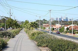
The Federation Trail is a 23-kilometre-long (14 mi) shared use path for cyclists and pedestrians, which mainly follows the heritage-listed Main Outfall Sewer through the western suburbs of Melbourne, Victoria, Australia. There are three bridges spanning across major arterial roads, as well as button-activated traffic light crossings at most other major road-trail intersections.

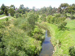
The Kororoit Creek is a watercourse of the Port Phillip catchment, rising in the outer north western suburbs of Melbourne, in the Australian state of Victoria.

The Ringwood to Belgrave Rail Trail is a shared use path for cyclists and pedestrians that follows the Belgrave railway line from the Mullum Mullum Creek Trail in Ringwood to Belgrave railway station in Belgrave, in the outer eastern suburbs of Melbourne, Victoria, Australia.
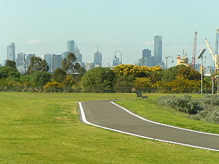
The Hobsons Bay Coastal Trail is a shared use path for cyclists and pedestrians, which follows the coast line of Hobsons Bay in the inner western suburbs in Melbourne, Victoria, Australia. The trail forms part of the western half of the Bayside Trail which encircles Port Phillip. It runs from the west side of the Westgate bridge, south and along the coast, finishing at the Skeleton Creek Trail in Sanctuary Lakes.
The Laverton Creek Trail is a shared use path for cyclists and pedestrians, which follows Laverton Creek in the outer western suburbs of Laverton and Altona in Melbourne, Victoria, Australia.

The Mullum Mullum Creek Trail is a shared use path for cyclists and pedestrians, which follows Mullum Mullum Creek in the outer eastern suburbs in Melbourne, Victoria, Australia. The Mullum Mullum Creek Trail extends from the Eastlink Trail at Sherbrook Park to Highland Avenue in Croydon.
The Skeleton Creek Trail is a shared use path for cyclists and pedestrians, which follows Skeleton Creek as it passes through the outer south western suburbs of Point Cook and Altona Meadows in Melbourne, Victoria, Australia.
The Northern Pipe Trail, is a shared-use path for cyclists and pedestrians that follows Cheddar and St Georges Roads in the northern suburbs of Reservoir, Preston and Thornbury in Melbourne, Victoria, Australia.

The M80 Trail is a shared-use path for cyclists and pedestrians that bridges the northern suburbs and follows the Western Ring Road/Metropolitan Ring Road (M80) freeway in Melbourne, Australia.

Cherry Lake is part of historical coastal wetlands in Altona, a suburb of Melbourne, Victoria, Australia. The wetlands were converted to a lake with construction of retaining walls, levees and flow channels. The lake and surrounding reserve is an important wildlife habitat and popular recreational destination.

Altona Coastal Park, a 70 hectares intertidal and salt marsh area located 11 km from Melbourne CBD in the western suburb of Altona, is an important recreational and nature conservation area, providing habitats for a large biodiversity of flora and fauna. It is part of the Cheetham and Altona Important Bird Area.

The Main Yarra Trail, also known as the Yarra Trail is a shared-use path for cyclists and pedestrians, which follows the Yarra River through the northeastern suburbs of Melbourne, Victoria, Australia.