
The Mornington Peninsula is a peninsula located south of Melbourne, Victoria, Australia. It is surrounded by Port Phillip to the west, Western Port to the east and Bass Strait to the south, and is connected to the mainland in the north. Geographically, the peninsula begins its protrusion from the mainland in the area between Pearcedale and an area north of Frankston. The area was originally home to the Mayone-bulluk and Boonwurrung-Balluk clans, and formed part of the Boonwurrung nation's territory prior to European settlement.

Pearcedale is a town in Victoria, Australia, 49 km south-east of Melbourne's Central Business District, located within the City of Casey and the Shire of Mornington Peninsula local government areas. Pearcedale recorded a population of 3,867 at the 2021 census.

Balnarring is a town in the south-eastern extremity of the Mornington Peninsula in Melbourne, Victoria, Australia, approximately 63 km (39 mi) south-east of Melbourne's Central Business District, located within the Shire of Mornington Peninsula local government area. Balnarring recorded a population of 2,371 at the 2021 census.

Bittern is a town on the Mornington Peninsula in Melbourne, Victoria, Australia, 61 km (38 mi) south-east of Melbourne's Central Business District, located within the Shire of Mornington Peninsula local government area. Bittern recorded a population of 4,276 at the 2021 census.

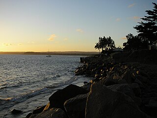
Flinders is a seaside town on the Mornington Peninsula in Melbourne, Victoria, Australia, 73 km (45 mi) south of Melbourne's Central Business District, located within the Shire of Mornington Peninsula local government area. Flinders recorded a population of 1,130 at the 2021 census.

Merricks is a town in the south-eastern extremity of the Mornington Peninsula in Melbourne, Victoria, Australia, approximately 65 km (40 mi) south-east of Melbourne's Central Business District, located within the Shire of Mornington Peninsula local government area. Merricks recorded a population of 184 at the 2021 census.
Point Leo is a small coastal village on the shore of Western Port bay on the eastern side of the Mornington Peninsula in Melbourne, Victoria, Australia, 67 km (42 mi) south-east of Melbourne's Central Business District, located within the Shire of Mornington Peninsula local government area. Point Leo recorded a population of 178 at the 2021 census.

Shoreham is a seaside surfing town located on the shore of Western Port bay on the Mornington Peninsula in the Australian state of Victoria. It lies within the Shire of Mornington Peninsula local government area, about 68 km (42 mi) south-east of the central business district of Melbourne. Shoreham recorded a population of 679 at the 2021 census.
Somers is a small coastal town on the Mornington Peninsula in Melbourne, Victoria, Australia, 67 km (42 mi) south-east of Melbourne's Central Business District, located within the Shire of Mornington Peninsula local government area. Somers recorded a population of 1,857 at the 2021 census.

Somerville is a town on the Mornington Peninsula in Melbourne, Victoria, Australia, 49 km (30 mi) south-east of Melbourne's Central Business District, located within the Shire of Mornington Peninsula local government area. Somerville recorded a population of 11,767 at the 2021 census.

Frankston railway station is a commuter railway station and the terminus of the Frankston line and diesel-hauled services on the Stony Point line, all part of the Melbourne railway network. It serves the south-eastern suburb of Frankston, in Melbourne, Australia and neighboring suburbs. Opening on the 1st of August 1882, features two side platforms, a terminus platform at Platform 1 and having Platform 2 for the terminus platform at the northern end of the platform and the Stony Point line services at the southern end. Its current form was constructed and completed in 2018.
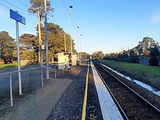
Tyabb railway station is a commuter railway station on the Stony Point line, part of the Melbourne railway network. It serves the town of Tyabb in Victoria, Australia. Tyabb is a ground level unstaffed station, featuring one side platform. It opened on 10 September 1889, with the current station provided in 1986. It initially closed on 22 June 1981, then reopened on 27 September 1984.

Nepean Highway is a major highway in Victoria, running south from St Kilda Junction in inner-southern Melbourne to Portsea, tracing close to the eastern shore of Port Phillip for the majority of its length. It is the primary road route from central Melbourne through Melbourne's southern suburbs. This name covers a few consecutive roads and is not widely known to most drivers except for its central section, as the entire allocation is still best known by the names of its constituent parts: St Kilda Road, Brighton Road and Nepean Highway proper, and Point Nepean Road. This article will deal with the entire length of the corridor for sake of completion.

The Mornington Peninsula Football Netball League (MPFNL), formerly known as the Mornington Peninsula Nepean Football League (MPNFL), is an Australian rules football competition, governed by the AFL South East. The MPFNL contains teams near the southeastern region of Melbourne, Victoria.
The County of Mornington is one of the 37 counties of Victoria which are part of the cadastral divisions of Australia, used for land titles. It is located to the south-east of Melbourne, including the Mornington Peninsula, French Island and Phillip Island. The county was proclaimed in 1849.
Western Port Highway is a highway in Victoria, Australia, linking the south-eastern fringe of suburban Melbourne to the port of Hastings nearly 30km to the south on the western coast of Western Port, after which the highway is named.
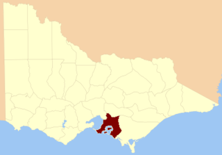
The Shire of Hastings was a local government area about 60 kilometres (37 mi) south-southeast of Melbourne, the state capital of Victoria, Australia, encompassing the eastern extremity of the Mornington Peninsula. The shire covered an area of 304.6 square kilometres (117.6 sq mi), and existed from 1960 until 1994.
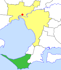
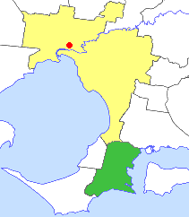
The Shire of Flinders was a local government area encompassing the extremity of the Mornington Peninsula, about 65 kilometres (40 mi) south of Melbourne, the state capital of Victoria, Australia. The shire covered an area of 324 square kilometres (125.1 sq mi), and existed from 1874 until 1994.
