Parklands adjoining the Yarra River

Last updated

Studley Park Boathouse on the Yarra River Studley Park Boathouse, Melbourne, Australia.jpg
Studley Park Boathouse on the Yarra River

The Yarra River is a river in southern Victoria, Australia that flows through the city of Melbourne. There are many parklands, including state parks and national parks, that adjoin the river along its 250 km length. Every park listed has walking tracks, smaller parks usually have unsealed paths, while bigger parks will have sealed pathways suitable for walking and cycling. The Yarra River Trail runs along much of the length of the river's lower reaches through Melbourne. Most parks listed have parking available, the quality and quantity of which varies according to the size of the park. Dogs are not permitted in parklands adjoining the river unless otherwise stated in special off-lead areas.

Yarra River river in Victoria, Australia

The Yarra River or historically, the Yarra Yarra River, is a perennial river in east-central Victoria, Australia.

Victoria (Australia) State in Australia

Victoria is a state in south-eastern Australia. Victoria is Australia's smallest mainland state and its second-most populous state overall, making it the most densely populated state overall. Most of its population lives concentrated in the area surrounding Port Phillip Bay, which includes the metropolitan area of its state capital and largest city, Melbourne, Australia's second-largest city. Victoria is bordered by Bass Strait and Tasmania to the south, New South Wales to the north, the Tasman Sea to the east, and South Australia to the west.

Melbourne City in Victoria, Australia

Melbourne is the capital and most populous city of the Australian state of Victoria, and the second most populous city in Australia and Oceania. Its name refers to an urban agglomeration of 9,992.5 km2 (3,858.1 sq mi), comprising a metropolitan area with 31 municipalities, and is also the common name for its city centre. The city occupies much of the coastline of Port Phillip bay and spreads into the hinterlands towards the Dandenong and Macedon ranges, Mornington Peninsula and Yarra Valley. It has a population of approximately 5 million, and its inhabitants are referred to as "Melburnians".

Contents

Parklands

Below is a list of parklands that adjoin the Yarra River, their locations and their uses (from downstream to upstream): [1]

Newport, Victoria Suburb of Melbourne, Victoria, Australia

Newport is an inner suburb of Melbourne, Victoria, Australia, 7 km south-west of the Melbourne central business district, located within the City of Hobsons Bay local government area. Newport had a population of 12,916 at the 2016 Census.

Spotswood, Victoria Suburb of Melbourne, Victoria, Australia

Spotswood is an inner-western suburb of Melbourne, Victoria, Australia, 7 km south-west of Melbourne's central business district. Its local government area is the City of Hobsons Bay. At the 2016 census, Spotswood had a population of 2,604.

Westgate Park is a former baseball stadium located in San Diego, California. The ballpark was home to the San Diego Padres of the Pacific Coast League from 1958 to 1967.

  • Gosch's Paddock (toilets, sporting oval)

Herring Island is a small 3.2 hectares artificial island located in Melbourne's Yarra River at South Yarra, approximately 3 kilometres (1.9 mi) from the city centre. It is the only island in the Yarra River.

  • Como Park North (barbecue, café, toilets, sporting oval)
Toorak, Victoria Suburb of Melbourne, Victoria, Australia

Toorak is an affluent inner suburb of Melbourne, Victoria, Australia, 5 km south-east of Melbourne's Central Business District, located within the City of Stonnington local government area. Toorak recorded a population of 12,909 at the 2016 Census.

Burnley, Victoria Suburb of Melbourne, Victoria, Australia

Burnley is a suburb of Melbourne, Victoria, Australia, 4 km east of Melbourne's Central Business District. Its local government area is the City of Yarra. At the 2011 Census, Burnley had a population of 769.

Hawthorn, Victoria Suburb of Melbourne, Victoria, Australia

Hawthorn is an inner suburb of Melbourne, Australia, 6 kilometres (3.7 mi) east of Melbourne's central business district situated in the City of Boroondara. At the 2016 Census, Hawthorn recorded a population of 23,511.

  • Dickinsons Reserve (picnic area, playground)
  • F.A. Andrews Reserve (playground, picnic area, canoe ramp)
  • Studley Park (restaurant, toilets, barbecues, boat hire, shelters, lookouts)
  • Deep Rock Picnic Area (toilet, sporting ovals)
  • Bellbird Picnic Area (toilet, shelter, barbecue, lookouts)
  • Fairfield Park (restaurant, toilets, barbecues, shelter, boat hire, playground, amphitheatre, sporting oval)
Alphington, Victoria Suburb of Melbourne, Victoria, Australia

Alphington is a suburb of Melbourne, Victoria, Australia, 7 km north-east of Melbourne's Central Business District. Its local government area are the Cities of Darebin and Yarra. At the 2016 census, Alphington had a population of 5,080.

Kew, Victoria Suburb of Melbourne, Victoria, Australia

Kew is an inner suburb of Melbourne, Australia, 5 km east from Melbourne's Central Business District. Its local government area is the City of Boroondara. At the 2016 Census, Kew had a population of 24,605.

Ivanhoe, Victoria Suburb of Melbourne, Victoria, Australia

Ivanhoe is a suburb of Melbourne, Victoria, Australia, 10 km north-east of Melbourne's Central Business District. Its local government area is the City of Banyule. At the 2016 Census, Ivanhoe had a population of 12,171.

  • Pound Bend (rangers office, walking trails, views)
  • Black Flat (walking trail, no dogs, no horses)
  • Jumping Creek (barbecues, toilets, canoe launching ramp)
  • Yarra Brae (walking trails)

(*) = Note: this list only includes parklands within the Warrandyte State Park that are adjoining the Yarra River.

See also

Related Research Articles

City of Manningham Local government area in Victoria, Australia

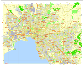
The City of Manningham is a local government area in Victoria, Australia in the north-eastern suburbs of Melbourne and is divided into 12 suburbs, with the largest being Doncaster and Doncaster East. It comprises an area of 114 square kilometres and had a population of 116,255 in 2016.

Bulleen, Victoria Suburb of Melbourne, Victoria, Australia

Bulleen is a suburb in Melbourne, Australia, 13 km north-east of the Melbourne central business district. Its local government area is the City of Manningham. At the 2016 Census, Bulleen had a population of 10,873.

Warrandyte, Victoria Suburb of Melbourne, Victoria, Australia

Warrandyte is a suburb of Melbourne, Victoria, Australia, 24 km north-east of Melbourne's Central Business District. Its local government area is the City of Manningham. At the 2011 census, Warrandyte had a population of 5,520.

Lower Plenty, Victoria Suburb of Melbourne, Victoria, Australia

Lower Plenty is a suburb of Melbourne, Victoria, Australia, 16 km north-east from Melbourne's Central Business District. Its local government area is the City of Banyule. At the 2016 Census, Lower Plenty had a population of 3,891.

Wonga Park, Victoria Town in Victoria, Australia

Wonga Park is a locality within Greater Melbourne, beyond the Melbourne Metropolitan Urban Growth Boundary area, 29 km north-east from Melbourne's Central Business District. Its local government area is the City of Manningham. At the 2011 census, Wonga Park had a population of 3,833.

Yarra Scenic Drive is a tourist drive following the Yarra River, in Victoria, Australia. The route traverses approximately 60 km from Warrandyte - where the Yarra diverts from any thoroughfares - to Williamstown - where the Yarra empties into Port Phillip Bay.

North Warrandyte, Victoria Suburb of Melbourne, Victoria, Australia

North Warrandyte is a suburb of Melbourne, Victoria, Australia, 25 km north-east of Melbourne's Central Business District. Its local government area is the Shire of Nillumbik. At the 2016 Census, North Warrandyte had a population of 2,956.

Westerfolds Park

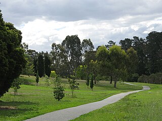
Westerfolds Park is a metropolitan park situated in Templestowe, an eastern suburb of Melbourne, Australia.

Division of Menzies Australian federal electoral division

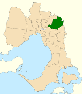
The Division of Menzies is an Australian Electoral Division in the state of Victoria. It is located in the north-eastern suburbs of Melbourne. It is bordered by the Yarra River to the north and Koonung Creek to the south. It covers the suburbs of Bulleen, Croydon Hills, Doncaster, Doncaster East, Donvale, Park Orchards, Templestowe, Templestowe Lower, Warrandyte and Warrandyte South. Additionally, parts of Ringwood North, Warranwood and Wonga Park fall under the Division.

Parks and gardens of Melbourne Parks and gardens in Melbourne, VIC, Australia

Melbourne is considered to be Australia's garden city, and Victoria as the Garden State. There is an abundance of parks and gardens close to the CBD with a variety of common and rare plant species amid landscaped vistas, pedestrian pathways, and tree lined avenues. The phrase Victoria – Garden State was used on Victorian car number plates from the 1970s to 1994, and many regional towns have well tended botanic gardens, parks and tree lined avenues.

Mullum Mullum Creek river in Victoria, Australia

Mullum Mullum Creek is a creek in the outer eastern suburbs of Melbourne, Victoria, Australia. It is the main watercourse of the Mullum Mullum Valley, a tributary of the Yarra River and Yarra Valley. For tens of thousands of years it was used as a food and tool source sustainably by the Wurundjeri people, Indigenous Australians of the Kulin nation, who spoke variations of the Woiwurrung language group.

Koonung Creek river in Victoria, Australia

Koonung Creek is a small tributary of the Yarra River in Melbourne's east. The creek originates in Nunawading near Springvale Road, and flows to join the Yarra at the border between Ivanhoe East, Bulleen and Balwyn North. The place the two waterways meet forms the borders between these suburbs. Bushy Creek is a tributary to the creek, joining near Elgar Park in Mont Albert North. A shared use path follows the course of the creek, known as the Koonung Creek Trail.

Yarra Bend Park park in Australia

Yarra Bend Park is a 260 hectare park in the Melbourne suburb of Kew. Located 4 km northeast of Melbourne's CBD, it is the largest area of natural bushland left in inner Melbourne. The most notable feature of the park is the Yarra River which flows for 12 km through it. The park hosts two golf courses, two historic boathouses, sheds and a number of cycle and walking trails. It receives approximately 1.5 million visitors per year.

Koomba Park

Koomba Park is one of the parks comprising the Dandenong Valley Parklands in the eastern suburbs of Melbourne, Australia. It consists of 92 hectares, of which 33 hectares are publicly accessible, and is bounded by the Dandenong Creek, Boronia Road, EastLink, Mountain Highway and Burwood Highway in a clockwise direction. The park opened in December 1981.

Ruffey Lake Park

Ruffey Lake Park is a park in the City of Manningham, Melbourne, Victoria, Australia. It is situated around Ruffey Lake in a portion of a valley through which the Ruffey Creek runs, forming the border between Doncaster and Templestowe. It has three main entrances, Victoria St, The Boulevard and King St. Despite being the second largest park in Manningham, second to Westerfolds Park, it is the biggest urban park managed by the City of Manningham. It is approximately 68 hectares in size. Formerly orchards, the park has a diverse ecology; this includes a riparian strip of native bushland around the creek, areas of pine trees planted by early settlers and pockets of fruit trees remaining from past orchards.

Main Yarra Trail

The Yarra Trail is a shared use path for cyclists and pedestrians, which follows the Yarra River through the north eastern suburbs of Melbourne, Victoria, Australia.

Warrandyte State Park

Warrandyte State Park is a state park, located in Warrandyte, east of Melbourne, Victoria on the banks of the Yarra River and surroundings. The park comprises 586 hectares of remnant bushland in various locations throughout Warrandyte and Wonga Park around Pound Bend, Fourth Hill, Black Flat, Yarra Brae and various other locations in the area. It hosts many significant geographical, environmental, archaeological and historical sites, such as the site of the first gold discovery in Victoria in 1851 and preserves the sites of former gold mines and tunnels. It is a popular destination for school and community groups and is frequented by local bush walkers and hikers.

Koonung Creek Reserve

Koonung Creek Reserve is a linear park in the suburb of Balwyn North, Melbourne, Australia. It follows the path of the Eastern Freeway from Bulleen Road in the west to Doncaster Road to the east.

Glass Creek is a waterway flowing through the inner-eastern suburbs of Melbourne. It is a minor tributary of the Yarra River and now largely runs through a series of underground drains.

References

  1. Melways, Edition 35, 2008