Yarra Ranges National Park

Last updated

Yarra Ranges National Park
Victoria
The Beeches Rainforest Walk 01 Pengo.jpg
A waterfall in the national park near Marysville
Australia Victoria relief location map.jpg
Red pog.svg
Yarra Ranges National Park
Nearest town or city Melbourne
Coordinates 37°40′50″S145°59′27″E / 37.68056°S 145.99083°E / -37.68056; 145.99083
EstablishedDecember 1995 (1995-12) [1]
Area760 km2 (293.4 sq mi) [1]
Visitation800,000 (in 2002) [1]
Managing authorities Parks Victoria
Website Yarra Ranges National Park
See also Protected areas of Victoria

Yarra Ranges National Park is located in the Central Highlands of Australia's southeastern state Victoria, 107 km northeast of Melbourne. Established in 1995 and managed by the statutory authority Parks Victoria, the park features a carbon-rich, temperate rainforest and a subalpine eucalypt forest on its northern plateau. It is home to large stands of mountain ash, the tallest tree species in Australia and among the tallest in the world. A wide diversity of fauna make their home across the park's 76,003 hectares, including kangaroos, wallabies, wombats, platypuses and 120 species of native birds. Among the conservation challenges facing Yarra Ranges National Park are climate change and invasive species of weeds.

Contents

In winter, Lake Mountain, located on the plateau at the northern end of the park, provides cross-country skiing on groomed and ungroomed ski trails.

Description

The Yarra Ranges National Park was created in December 1995, and spans 76,003 hectares within Victoria's Central Highlands. [2] This National Park has been given "the International Union for the Conservation of Nature (IUCN) Category 2 (National Parks) of the United Nations List of National Parks and Protected Areas". [3] By being category 2, it means that the park is primarily managed for the ecosystem conservation and appropriate recreation within it. The park is made up of wet Mountain Ash Forest and Cool Temperate Rainforest, [4] as well as a diverse range of flora and fauna species. Mount Donna Buang, standing 1,245 metres above the town of Warburton [5] is the parks largest mountain. The park encompasses the headwaters of the Yarra, O'Shannassy and Taggerty Rivers, as well as their reservoirs, which make up 70% of Melbourne's water supply. [2] This is because 84% of the park is within the Designated Water Supply Catchment Area (DWSCA) which is managed under the Government's Closed Catchment Policy. [6] Because of this, much of the park has limited access to the public to better protect the water supply catchments.

Ecology

Victoria's Mountain Ash trees (Eucalyptus regnans) are among the most spectacular trees in the world being one of the world's tallest tree species, as well as the tallest flowering plant. [7]

Mountain Ash trees in the Black Spur, Yarra Ranges, Victoria MountainAshWithCars.jpg
Mountain Ash trees in the Black Spur, Yarra Ranges, Victoria

The Mountain ash trees have a lifespan of 400 years and tower up to 90 metres, [8] though have been known to grow taller with the highest ever recorded being the "Ferguson Tree," discovered near Healesville in 1872 standing at over 154 metres high. They grow in stands that have the highest above-ground biomass of any trees in the world, allowing them to store large quantities of carbon dioxide. In 2009, a study was conducted by Professor Brendan Mackey of the Australian National University, who found that Mountain Ash forests are the best in the world at locking up carbon, storing 1,867 tonnes of carbon per hectare. [9] Once they have reached the end of their lifespan, their dead tree stumps and fallen logs continue to provide homes for at least 40 hollow-dependant species, including Victoria's faunal emblem – the endangered Leadbeater's Possum (Gymnobelideus leadbeateri) [10] – as well as the Mountain Brushtail Possum (Trichosurus cunninghami) and the Greater Glider (Petauroides volans). There have also been nine epiphyte species that have been observed growing on the Mountain Ash trees, the most prevalent of these being Liverwort (Bazzania adnexa). [11] Other than Mountain Ash trees, the park also contains several threatened species of flora, including the Slender Tree Fern (Cyathea cunninghamii).

Leadbeater's Possum Leadbeater's Possum 02 Pengo.jpg
Leadbeater's Possum

The park provides a habitat for many native species of fauna. There are over 120 recorded species of native birds, [2] with some notable species being the Pink Robin (Petroica rodinogaster), Yellow-tailed black cockatoo (Calyptorhynchus funereus), Australian King Parrot (Alisterus scapularis) and the Grey Goshawk (Accipiter novaehollandiae). [12] The park also contains three species of threatened owl – Sooty Owl (Tyto tenebricosa), Powerful Owl (Ninox strenua) and the Barking Owl (Ninox connivens). Native mammals that are frequently seen within the park are Kangaroos, Wallabies and Wombats. The waterways are abundant with Platypuses, as well as many species of fish, including Redfin perch (Perca fluviatillis), European carp (Cyprinus carpio) and Golden perch (Macquaria ambigua). When it comes to insects, Mount Doona Buang is home to an endemic rare species known as the Mount Donna Buang Wingless Stonefly (Riekoperla darlingtoni). [13] [14]

Environmental threats

Weeds and feral animals

One of the most major environmental threats against the Yarra Ranges National Park is invasive weeds. The park is rich with native plants that are being overcome by competition by the 200 species of weeds that are spreading into the park from private gardens. [15] In the park there are three significant types of weeds:

Invasive pest animals can have detrimental effects on the park because they prey on native wildlife and can "out-compete and displace native animals by competing for their habitat, food and water resources". [18] Red foxes (Vulpes vulpes) are an established pest animal in all of Victoria. [19] When it comes to the Yarra Ranges National Park, mainly trapping methods are employed to manage the issue. In Victoria there is a program that rewards eligible Victorian hunters with a $10 bounty reward for each individual fox killed, [20] subject to the Victorian Fox Bounty Terms and Conditions. Due to this, and the amount of foxes in the park, Parks Victoria opens up the park occasionally to allow hunters in to help manage the fox issue. Other pest animals within the park are European Rabbits (Oryctolagus cuniculus) and feral cats. [21]

Fires

Fires are a natural part of Australian environment because they are needed for the renewal of ecosystems; [22] however, in recent times these bushfires have been occurring outside normal frequencies, intensities, seasons and scale of what fauna and flora can tolerate. [23] To reduce the potential impact of fire on the park, controlled burns are conducted throughout specific months of the year and are carefully managed by Parks Victoria and the Department of Environment, Land, Water and Planning (DELWP). [24] The controlled burns are used to reduce the amount of fuel, such as dead wood, leaf litter, bark or shrubs that could easily catch alight during the summer months. [25] A reduced amount of fuel decreases the impact of a bushfire because it lowers its intensity.

Climate change

Climate change is having a major impact on all ecosystems within Australia, and the Yarra Ranges National Park is no exception. As the temperature increases, the average rainfall decreases, meaning less water flowing in the waterways. [26] Less water reduces water quality that is supplied to Melbourne and used by the fauna and flora within the park. The annual surface temperature is predicted to increase by 0.6-1C and wind speed is set to increase by 6%. [27] All these changes will impact what makes up the park's ecosystem and how it functions.

Heritage

European colonists found it difficult to access the area. It was eventually settled in 1860 and was seen as a valuable area for timber. Soon after, the area was recognised as a good place for water catchments, so the Maroondah and Upper Yarra dams were built. [28]

Management

Yarra Ranges National Park is managed by Parks Victoria, the Department of Environment, Land, Water and Planning (DELWP) and Melbourne Water. Parks Victoria released a Management Plan for the park in 2002 [2] in which they outlined the significant management directions for the Park, all of which are still used today.

Parks Victoria aims to preserve significant conservation areas by; Preserving old-growth forests, as well as specific significant flora species. Parks will do this by improving knowledge of flora in the park by encouraging flora surveys and research on significant species to improve conservation management schemes for specific species. To provide special protection for significant plant species by actively managing threatening processes, such as weed invasion. [29] To protect the parks native fauna species and maintain genetic diversity. This will be done by maintaining and enhancing fauna habitat through the control of potentially threatening processes, such as pest plant and animal control. To encourage surveys of fauna and faunal habitats in the park, giving priority to threatened species to ensure that the park continues to support viable populations of each endangered species. [2] The last management strategy to protect fauna species is to communicate the policy of no feeding of wildlife in the park, and to prohibit the distribution and sale of birdseed within the park. When it comes to fire management, Parks Victoria allows open days for locals to come into the park and gather wood. This helps to get rid of fire fuel that is present in the understory of the forest.

Protecting water resources in the water supply catchments. This will be done by maintaining the Restricted Access Policy for the Designated Water Supply Catchment Area (DWSCA), by continuing to prohibit domestic pets and control feral animals in the DWSCA to protect the water resources from any potential forms of contamination. The DWSCA will also be protected from wildfire in accordance with the Draft Yarra Ranges National Park Fire Protection Plan. [30] The last management strategy to protect the water supply catchments is to monitor the effects of roads and traffic that transverse the DWSCA to ensure that there is minimal soil erosion that could affect the water supply.

Are the management directions effective?

The current management strategies outlined in the Yarra Ranges National Park Management Plan [2] regarding the Restricted Access Policy, is efficient at maintaining the parks water resources. By limiting human access to the Designated Water Supply Catchment Area (DWSCA) it prevents some forms of contaminants from entering the supply catchments because the area remains clear of rubbish. If rubbish left behind in the park by people entered the water catchments, it could have a damaging effect on the purity of the water that is supplied to Melbourne. The restriction on people feeding wildlife has also benefited the native species within the park because it allows the ecosystem to function and evolve without human interference.

One of the main reasons the park was established was to protect Mountain Ash trees, however, their numbers have declined due to climate change, bush fires and close-proximity logging to the park. Climate change cannot be prevented, but significant fire damage can be. To decrease the severity of fires within the Park, more planned burns to get rid of a majority of fire fuel could be implemented by Parks Victoria and DELWP. [31] When it comes to close-proximity logging, the effect on Mountain Ash trees is detrimental. To help prevent the further loss of these endangered carbon-rich forests, a policy could be implement by the Victorian Government to prevent logging from occurring within a 20 kilometre area of the park.

With the number of Mountain Ash trees decreasing, faunal habitat is also being lost. This is of great concern when it comes to Victoria's faunal emblem – the Leadbeater's Possum, as well as many other threatened species of fauna within the park. Parks Victoria and DELWP have management strategies in place that do protect these threatened species from pest species and human interaction, however there are no measures to combat the increased threat of climate change. When it comes to protecting threatened species of fauna, there are breeding programs implemented in Healesville Sanctuary to increase specific species population rates. [32] Once these animals reach a certain age, Zoo's Victoria coordinates their efforts with the Parks Ranger, to release these animals into the park. In regards to faunal habitat being lost, the parks open wood days may be displacing animals if people do not stick to the restriction for wood collection in the park. This cannot be managed, so the only way to prevent this is to find a way to manage it, or to stop the open wood days altogether.

To help better protect endangered fauna and flora within the area, there is a proposal for the creation of the Great Forest National Park. [33] This proposed park will add 355,000 hectares to existing parks and reserves. The proposed park will supply over 4 million people with some of the highest quality drinking water, help to protect a greater portion of Mountain Ash forest and provide a greater area for protecting endangered and rare wildlife. Overall, the proposed park will protect approximately all of Victoria's Central Highlands.

See also

Related Research Articles

<span class="mw-page-title-main">Biriwal Bulga National Park</span> Protected area in New South Wales, Australia

Biriwal Bulga National Park is an Australian national park in New South Wales. It is approximately 45 km north west of Taree and 60 km west of Port Macquarie on the Bulga Plateau.

<span class="mw-page-title-main">Brisbane Water National Park</span> Protected area in New South Wales, Australia

Brisbane Water National Park is a national park on the Central Coast of New South Wales, Australia. The national park is situated 70 kilometres (43 mi) north of Sydney and 12 kilometres (7.5 mi) southwest of Gosford. It consists the Brisbane Water and Mooney Mooney Creek waterways.

<span class="mw-page-title-main">Chiltern-Mt Pilot National Park</span> Protected area in Victoria, Australia

The Chiltern-Mt Pilot National Park is a national park that is located in the Hume region of Victoria, Australia. The 21,650-hectare (53,500-acre) national park is situated approximately 275 kilometres (171 mi) northeast of Melbourne, and extends west from Beechworth across the Hume Freeway and the Albury-Melbourne railway line to the west of Chiltern.

<span class="mw-page-title-main">Eungella National Park</span> Protected area in Queensland, Australia

Eungella National Park is a protected area in Queensland, Australia. It is on the Clarke Range at the end of the Pioneer Valley 80 km west of Mackay, and 858 km northwest of Brisbane. Eungella is noted for the national park which surrounds it. It is considered to be the longest continual stretch of sub-tropical rainforest in Australia. The original inhabitants are the Wirri people. The park is covered by dense rainforest and is known for its platypuses.

<i>Eucalyptus regnans</i> Species of eucalyptus

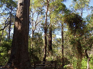
Eucalyptus regnans, known variously as mountain ash, swamp gum, or stringy gum, is a species of medium-sized to very tall forest tree that is native to the Australia states of Tasmania and Victoria. It is a straight-trunked tree with smooth grey bark, but with a stocking of rough brown bark at the base, glossy green, lance-shaped to curved adult leaves, flower buds in groups of between nine and fifteen, white flowers, and cup-shaped or conical fruit. It is the tallest of all flowering plants; the tallest measured living specimen, named Centurion, stands 100 metres tall in Tasmania.
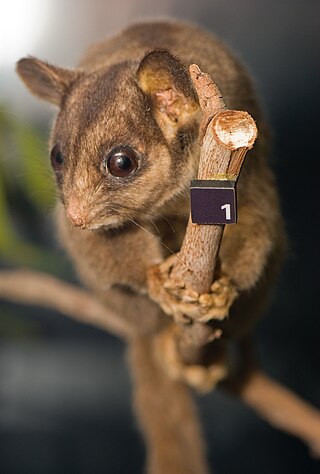
<span class="mw-page-title-main">Victorian Alps</span>

The Victorian Alps, also known locally as the High Country, is a large mountain system in the southeastern Australian state of Victoria. Occupying the majority of eastern Victoria, it is the southwestern half of the Australian Alps, the tallest portion of the Great Dividing Range. The Yarra and Dandenong Ranges, both sources of rivers and drinking waters for Melbourne, are branches of the Victorian Alps.

<span class="mw-page-title-main">Mount Donna Buang</span> Mountain in Victoria, Australia

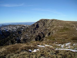
Mount Donna Buang is a mountain in the southern reaches of the Victorian Alps of the Great Dividing Range, located in the Australian state of Victoria. Approximately 94 kilometres (58 mi) from Melbourne with an elevation of 1,250 metres (4,101 ft), Mount Donna Buang is the closest snowfield to Melbourne.

<span class="mw-page-title-main">Steavenson Falls</span> Waterfall in Australia

Steavenson Falls, a waterfall on the Steavenson River, is located 4 kilometres (2.5 mi) southeast of Marysville, Victoria, Australia. The falls are one of the tallest in Victoria, with five cascades, a total descent of 122 metres (400 ft), the last having a clear drop of more than 21 metres (69 ft).

<span class="mw-page-title-main">Cathedral Range State Park</span> Protected area in Victoria, Australia

The Cathedral Range State Park located in Victoria, Australia, approximately 100 kilometres (62 mi) north-east of Melbourne. It is situated between the towns of Buxton and Taggerty and runs parallel to the Maroondah Highway. The Cathedral Range was declared a State Park on 26 April 1979. It consists of 3,577 hectares and contains the rugged Razorback and spectacular peaks of the Cathedral Range, Little River and forested hills of the Blue Range. Due to its proximity to Melbourne the Cathedral Ranges are a popular destination for both day and weekend adventures. Bushwalking, camping, rock climbing and abseiling are some of the more popular activities available. Cathedral Range State Park is listed as Category II under the IUCN World Commission on Protected Areas and is an example of a park that can be used for recreation, education and conserving natural ecosystems.

<span class="mw-page-title-main">Helmeted honeyeater</span> Subspecies of bird

The helmeted honeyeater is a passerine bird in the honeyeater family. It is a distinctive and critically endangered subspecies of the yellow-tufted honeyeater, that exists in the wild only as a tiny relict population in the Australian state of Victoria, in the Yellingbo Nature Conservation Reserve. It is Victoria's only endemic bird, and was adopted as one of the state's official symbols.

Riekoperla darlingtoni, the Mount Donna Buang wingless stonefly, is a species of stonefly in the family Gripopterygidae, which is endemic to Australia.

<span class="mw-page-title-main">Forests of Australia</span>

Australia has many forests of importance due to significant features, despite being one of the driest continents. As of 2009, Australia has approximately 147 million hectares of native forest, which represents about 19% of Australia's land area. The majority of Australia's trees are hardwoods, typically eucalypts, rather than softwoods like pine. While softwoods dominate some native forests, their total area is judged insufficient to constitute a major forest type in Australia's National Forest Inventory. The Forests Australia website provides up-to-date information on Australia's forests. Detailed information on Australia's forests is available from Australia's State of the Forests Reports that are published every five years.

<span class="mw-page-title-main">Barmah National Park</span> Protected area in Victoria, Australia

The Barmah National Park, formerly Barmah State Park, is a national park located in the Hume region of the Australian state of Victoria. The park is located adjacent to the Murray River near the town of Barmah, approximately 225 kilometres (140 mi) north of Melbourne. The park consists of river red gum floodplain forest, interspersed with treeless freshwater marshes. The area is subject to seasonal flooding from natural and irrigation water flows.

<span class="mw-page-title-main">Yellingbo Nature Conservation Reserve</span> Protected area in Victoria, Australia

Established in 1965, the Yellingbo Nature Conservation Reserve is located 45 km east of Melbourne in the Upper Yarra Valley, near the towns of Yellingbo, Launching Place, Yarra Junction, Hoddles Creek, Cockatoo, Emerald, Monbulk and Seville. Yellingbo Nature Conservation Reserve is a narrow riparian reserve with stream-frontage land along the Woori Yallock, Shepherd, Cockatoo, Macclesfield and Sheep Station Creeks.

The Warby-Ovens National Park is a national park located on the lands of the Bangerang clan of the Yorta Yorta Nation in the Hume region of Victoria, Australia near Killawara. The 14,655-hectare (36,210-acre) national park is situated approximately 10 kilometres (6.2 mi) west of Wangaratta and 240 kilometres (150 mi) northeast of Melbourne.
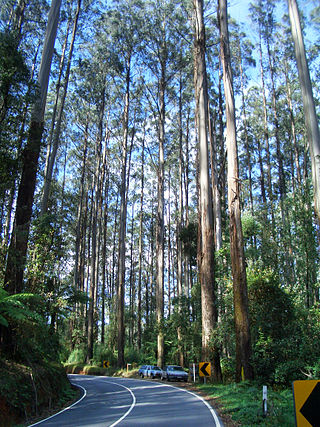
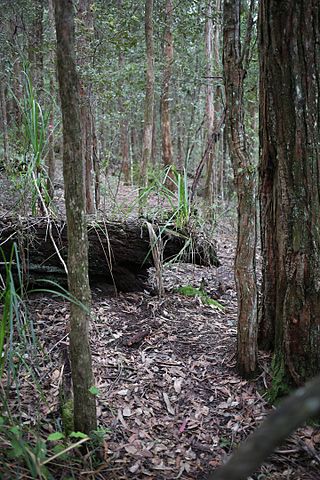
<span class="mw-page-title-main">Wombat State Forest</span> Protected area in Victoria, Australia

The Wombat State Forest is located 50 kilometres (31 mi) west of Melbourne, Victoria, Australia, between Woodend and Daylesford, at the Great Dividing Range. The forest is approximately 70,000 hectares in size and sits upon Ordovician or Cenozoic sediments. The Bullarook Wombat State Forest was proclaimed in 1871.

The Kangaroo River Nature Reserve, part of the Kangaroo Valley Group of Nature Reserves, is a protected nature reserve that is located on the floor of the Kangaroo Valley in the Southern Highlands and South Coast regions of New South Wales in eastern Australia. The reserve is situated approximately 150 kilometres (93 mi) south of Sydney, 50 kilometres (31 mi) southwest of Wollongong and 16 kilometres (9.9 mi) northwest of Nowra. The reserve has a protective covenant placed upon it with purpose to ensure the protection of the natural heritage of this area. National parks in the area include the Morton National Park and the Budderoo National Park. Other nature reserves in the area include the Barren Grounds Nature Reserve, and the Cambewarra Range, Barrengarry and Rodway nature reserves – the latter three part of the Kangaroo Valley Group of Nature Reserves.

<span class="mw-page-title-main">Dharawal National Park</span> Protected area in New South Wales, Australia

The Dharawal National Park is a protected national park that is located in the Illawarra region of New South Wales, in eastern Australia. The 6,508-hectare (16,080-acre) national park is situated between the Illawarra Range and the Georges River and is approximately 45 kilometres (28 mi) south west of Sydney. There are three entry points to the park: from the east through Darkes Forest; from the north through Wedderburn; and from the south through Appin.

<span class="mw-page-title-main">Cambewarra Range Nature Reserve</span>

The Cambewarra Range Nature Reserve, as part of the Kangaroo Valley Group of Nature Reserves, is a protected area located on the cliffs and plateaus of the Kangaroo Valley in the Southern Highlands and South Coast regions of New South Wales in eastern Australia. The Reserve is situated approximately 150 kilometres (93 mi) south of Sydney, 50 kilometres (31 mi) southwest of Wollongong and 16 kilometres (9.9 mi) northwest of Nowra. The Reserve has a total area of 1684 hectares, and includes 11 privately owned properties. It is critical for it to be pristine for a variety of reasons, not the least the catchment of water, as the Reserve floor flows into the Kangaroo Valley River and the Shoalhaven River, from which the Sydney Water Authority draws water to supply large populations in Sydney and Wollongong.

<span class="mw-page-title-main">Forests Commission Victoria</span> Government authority managing forests in Victoria, Australia

The Forests Commission Victoria (FCV) was the main government authority responsible for management and protection of State forests in Victoria, Australia between 1918 and 1983.

References

  1. 1 2 3 Yarra Ranges National Park management plan (PDF) (PDF). Government of Victoria. June 2002. ISBN   0-7311-3134-7 . Retrieved 5 August 2014.{{cite book}}: |work= ignored (help)
  2. 1 2 3 4 5 6 , Parks Victoria, Yarra Ranges National Park Management Plan, 2002.
  3. , IUCN, Protected Areas Categories System – Category II, 2014.
  4. , Elith, J. and Burgman, M.A., 2002. Predictions and their validation: rare plants in the Central Highlands, Victoria, Australia. Predicting species occurrences: issues of accuracy and scale, pp.303-314.
  5. , Howard T.M., Studies in the Ecology of Nothofagus Cunninghamii Oerst. i Natural Regeneration on the Mt. Donna Buang Massif Victoria, 1973, Australian Journal of Botany 21(1) 67 – 78.
  6. , Closed Catchment Policy, Melbourne Water, 2002.
  7. Mifsud, Brett M. (2003). "Victoria's tallest trees". Australian Forestry. 66 (3): 197–205. doi:10.1080/00049158.2003.10674912. S2CID   13696734.
  8. , Lindenmayer, D., Blair, D., McBurney, L. and Banks, S., 2015, Mountain Ash: Fire, Logging and the Future of Victoria's Giant Forests, CSIRO Publishing, pgs 200, ISBN   9781486304974.
  9. Keith, Heather; Mackey, Brendan; Lindenmayer, David B (2009). "Re-evaluation of forest biomass carbon stocks and lessons from the world's most carbon-dense forests". Proceedings of the National Academy of Sciences of the United States of America. 106 (28): 11635–40. doi: 10.1073/pnas.0901970106 . PMC   2701447 . PMID   19553199.
  10. Lindenmayer, D.B.; Meggs, R.A. (1996). "Use of den trees by Leadbeater's Possum (Gymnobelideus leadbeateri)". Australian Journal of Zoology. 44 (6): 625–638. doi:10.1071/zo9960625.
  11. "Epiphytes on Nothofagus Cunninghamii and Eucalyptus Regnans in a Victorian Cool Temperate Rainforest," Kellar, Claudette; Short, Megan; Milne, Josephine, 2006, The Victorian Naturalist, pp. 222–229. ISSN 0042-5184.
  12. , Longmore, W., 2011. Birds of the Yarra Catchment and where to find them, Victorian Naturalist, 128(5), p.251.
  13. , Ahern, L.D., Tsyrlin, E. and Myers, R., 2003. Mount Donna Buang Wingless Stonefly Riekoperla darlingtoni. Action Statement, (125).
  14. , Neumann, F.G. and Morey, J.L., 1984, A study of the rare wingless stonefly, Riekoperla darlingtoni (Illies), near Mount. Donna Buang, Victoria, Forest Commission Victoria, Vol. 253.
  15. [],Blair, D. and Blair, S., 2005. Shire of Yarra Ranges Weed Management Strategy. Shire of Yarra Ranges, Lilydale, Victoria.
  16. [], Weeds of National Significance 2009. Commonwealth of Australia.
  17. , Parsons, W.T. and Cuthbertson, E.G., 2001. Noxious weeds of Australia. CSIRO publishing.
  18. [], McLeod, R. and Norris, A., 2004. Counting the cost: impact of invasive animals in Australia, 2004 (p. 71). Canberra: Cooperative Research Centre for Pest Animal Control.
  19. , Kirkwood, R., Sutherland, D.R., Murphy, S. and Dann, P., 2014. Lessons from long-term predator control: a case study with the red fox. Wildlife Research, 41(3), pp.222-232.
  20. , McGeary, J., 2005. Enhanced Fox Management Program-phase 2 baseline survey. In 13th Australasian Vertebrate Pest Conference, Wellington, New Zealand, pp. 33-38, Manaaki Whenua Press, Landcare Research.
  21. "Feral cats". Department of Climate Ehange, Energy, the Environment and Water. Retrieved 15 December 2023.
  22. Attiwill, Peter (1992). "Productivity ofEucalyptus regnansForest Regenerating after Bushfire". South African Forestry Journal. 160: 1–6. doi:10.1080/00382167.1992.9630403.
  23. Myerscough, Peter (2003). "Flammable Australia. The Fire Regimes and Biodiversity of a Continent". Austral Ecology. 28 (5): 587. doi:10.1046/j.1442-9993.2003.01317.x.
  24. New, T.R.; Yen, A.L.; Sands, D.P.A.; Greenslade, P.; Neville, P.J.; York, A.; Collett, N.G. (2010). "Planned fires and invertebrate conservation in south east Australia". Journal of Insect Conservation. 14 (5): 567–574. doi:10.1007/s10841-010-9284-4. S2CID   25941329.
  25. Russell-Smith, J.; Yates, C.P.; Whitehead, P.J.; Smith, R.; Craig, R.; Allan, G.E.; Thackway, R.; Frakes, I.; Cridland, S.; Meyer, M.C.; Gill, A.M. (2007). "Bushfires' down under': patterns and implications of contemporary Australian landscape burning". International Journal of Wildland Fire. 16 (4): 361–377. doi:10.1071/wf07018.
  26. Kiem, A.S.; Austin, E.K. (2013). "Drought and the future of rural communities: Opportunities and challenges for climate change adaptation in regional Victoria, Australia". Global Environmental Change. 23 (5): 1307–1316. doi: 10.1016/j.gloenvcha.2013.06.003 . hdl: 1959.13/1299107 .
  27. Hughes, L.; Steffen, W. (2013). "Climate change in Victoria: trends, predictions and impacts". Proceedings of the Royal Society of Victoria. 125 (1/2): 5. doi: 10.1071/rs13003 .
  28. "Yarra Ranges National Park". Parks Victoria.
  29. [], Blair, D. and Blair, S., 2005. Shire of Yarra Ranges Weed Management Strategy. Shire of Yarra Ranges, Lilydale, Victoria.
  30. Hughes, Rachel (2009). "Planning to Reduce Risk: The Wildfire Management Overlay in Victoria, Australia". Geographical Research. 47 (2): 124–141. doi:10.1111/j.1745-5871.2008.00556.x.
  31. McCarthy, Michael A (1999). "Fire regimes in mountain ash forest: evidence from forest age structure, extinction models and wildlife habitat". Forest Ecology and Management. 124 (2–3): 193–203. doi:10.1016/S0378-1127(99)00066-3.
  32. , Harley, D., 2012. The application of Zoos Victoria's fighting extinction commitment to the conservation of leadbeater's possum 'Gymnobelideus leadbeateri'. Victorian Naturalist, 129(5), p.175.
  33. , Rees, S., 2014. A new national park. Interaction, 42(4), p.8.