
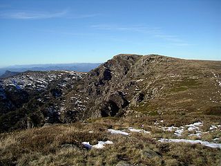
Namadgi National Park is a protected area in the south-west of the Australian Capital Territory (ACT), bordering Kosciuszko National Park in New South Wales. It lies approximately 40 kilometres (25 mi) southwest of Canberra, and occupies approximately 46 percent of the ACT's land area.
The Alpine National Park is a national park located in the Central Highlands and Alpine regions of Victoria, Australia. The 646,000-hectare (1,600,000-acre) national park is located northeast of Melbourne. It is the largest National Park in Victoria, and covers much of the higher areas of the Great Dividing Range in Victoria, including Victoria's highest point, Mount Bogong at 1,986 metres (6,516 ft) and the associated subalpine woodland and grassland of the Bogong High Plains. The park's north-eastern boundary is along the border with New South Wales, where it abuts the Kosciuszko National Park. On 7 November 2008 the Alpine National Park was added to the Australian National Heritage List as one of eleven areas constituting the Australian Alps National Parks and Reserves.

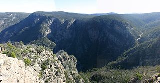
The Oxley Wild Rivers National Park is a protected national park that is located in the Northern Tablelands region of New South Wales, Australia in the Port Macquarie-Hastings City Council and Walcha Shire councils. The 145,223-hectare (358,850-acre) park is situated 445 kilometres (277 mi) north of Sydney and is named in memory of the Australian explorer John Oxley, who passed through the area in 1818 and is one of the largest national parks in New South Wales.

The Kinglake National Park is a national park in Central Victoria, Australia. The 23,210-hectare (57,400-acre) national park is situated 50 kilometres (31 mi) northeast of Melbourne and includes tracks, and camping facilities.
The Snowy River National Park is a national park located in the Alpine and East Gippsland regions of Victoria, Australia. The 98,700-hectare (244,000-acre) national park is situated approximately 390 kilometres (240 mi) northeast of Melbourne and 350 kilometres (220 mi) southwest of Canberra, south of the Black-Allan Line that marks part of the border between Victoria and New South Wales.

The Gondwana Rainforests of Australia, formerly known as the Central Eastern Rainforest Reserves, are the most extensive area of subtropical rainforest in the world. Collectively, the rainforests are a World Heritage Site with fifty separate reserves totalling 366,500 hectares from Newcastle to Brisbane.
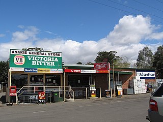
Anakie is a rural township between Geelong and Bacchus Marsh, in Victoria, Australia. At the 2021 census, Anakie and the surrounding area had a population of 734. The area is divided between the City of Greater Geelong and Golden Plains Shire local government areas.

The yellow-footed rock-wallaby, formerly known as the ring-tailed rock-wallaby, is a member of the macropod family.

One of the most extensive bushfire seasons in Australia's history. Victoria experienced the longest continuously burning bushfire complex in Australia's history, with fires in the Victorian Alps and Gippsland burning over 1 million hectares of land over the course of 69 days. See Bushfires in Australia for an explanation of regional seasons.

The Australian bushfire season ran from late December 2008 to April/May 2009. Above average rainfalls in December, particularly in Victoria, delayed the start of the season, but by January 2009, conditions throughout South eastern Australia worsened with the onset of one of the region's worst heat waves. On 7 February, extreme bushfire conditions precipitated major bushfires throughout Victoria, involving several large fire complexes, which continued to burn across the state for around one month. 173 people lost their lives in these fires and 414 were injured. 3,500+ buildings were destroyed, including 2,029 houses, and 7,562 people displaced.

The state of Victoria in Australia has had a long history of catastrophic bushfires, the most deadly of these, the Black Saturday bushfires of 2009 claiming 173 lives. Legislation, planning, management and suppression are the responsibilities of the Victorian State Government through its departments and agencies including the Country Fire Authority (CFA) and the Department of Environment, Land, Water and Planning (DELWP).

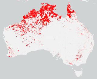
Bushfires in Australia are a widespread and regular occurrence that have contributed significantly to shaping the nature of the continent over millions of years. Eastern Australia is one of the most fire-prone regions of the world, and its predominant eucalyptus forests have evolved to thrive on the phenomenon of bushfire. However, the fires can cause significant property damage and loss of both human and animal life. Bushfires have killed approximately 800 people in Australia since 1851, and billions of animals.

A bushfire season occurred predominantly from June 2009 to May 2010. Increased attention has been given to this season as authorities and government attempt to preempt any future loss of life after the Black Saturday bushfires during the previous season, 2008–09. Long range weather observations predict very hot, dry and windy weather conditions during the summer months, leading to a high risk of bushfire occurrence.
Toorourrong Reservoir is a small water supply reservoir located on the southern slopes of the Great Dividing Range approximately 40 kilometres (25 mi) north of Melbourne, Victoria, Australia. The reservoir is formed by the Toorourrong Dam across the Plenty River, and an interbasin transfer. The dam is operated by Melbourne Water and the reservoir forms part of the Melbourne water supply system. Water from the Toorourrong Reservoir flows by aqueduct to the Yan Yean Reservoir.

The summer of 2012–13, had above average fire potential for most of the southern half of the continent from the east coast to the west. This is despite having extensive fire in parts of the country over the last 12 months. The reason for this prediction is the abundant grass growth spurred by two La Niña events over the last two years.
The bushfire season in the summer of 2014–15, was expected to have the potential for many fires in eastern Australia after lower than expected rainfall was received in many areas. Authorities released warnings in the early spring that the season could be particularly bad.

The most destructive bushfire season in terms of property loss since the 2008–09 Australian bushfire season, occurred in the summer of 2015–16, with the loss of 408 houses and at least 500 non-residential buildings as a result of wild fires between 1 June 2015 and 31 May 2016. The season also suffered the most human fatalities since the 2008–09 Australian bushfire season; 6 died in Western Australia, 2 in South Australia and 1 in New South Wales. 8 deaths were as a direct result of fire, and a volunteer firefighter died due to unrelated health complications while on duty.

The bushfire season of the summer of 2017–18, was expected to have above normal bushfire risks with an elevated fire risk for the most of eastern and south Australian coastal areas. Australia had experienced its warmest winter on record and the ninth driest winter on record leaving dry fuel loads across much of southern Australia. Expected warmer weather over the summer period would also increase the risk. Bushfires were also expected to occur earlier, before the end of winter, as a result of the warm and dry winter. Both Queensland and north-eastern New South Wales experienced the wettest October since 1975 leading to a downgrade in bushfire risk.

The 2019–20 Australian bushfire season or Black Summer was a period of bushfires in many parts of Australia, which, due to its unusual intensity, size, duration, and uncontrollable dimension, is considered a megafire. In June 2019, it was predicted that an early start to the bushfire season, which usually begins in August, may have been possible due to exceptionally dry conditions, a lack of soil moisture and early fires in Central Queensland. Throughout the summer, hundreds of fires burnt, mainly in the southeast of the country. The major fires peaked during December 2019 to January 2020.


