Macquarie River (Tasmania)

Last updated

Macquarie
Ross Bridge.jpg
Relief Map of Tasmania.png
Red pog.svg
Location of the Macquarie River mouth in Tasmania
Etymology Lachlan Macquarie
Location
Country Australia
State Tasmania
Region Midlands (Tasmania)
Settlement Ross
Physical characteristics
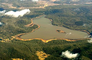
Source Tooms Lake
  locationHobgoblin
  coordinates 42°1′54″S147°45′53″E / 42.03167°S 147.76472°E / -42.03167; 147.76472
  elevation606 m (1,988 ft)
Mouth South Esk River
  location
Longford
  coordinates
41°35′14″S147°7′31″E / 41.58722°S 147.12528°E / -41.58722; 147.12528 Coordinates: 41°35′14″S147°7′31″E / 41.58722°S 147.12528°E / -41.58722; 147.12528
  elevation
189 m (620 ft)
Length189 km (117 mi)
Basin features
River system South Esk River
Tributaries 
  leftTooms River, Blackman River, Isis River, Lake River
  right Elizabeth River
[1]

The Macquarie River (Indigenous palawa kani : tinamarakunah [2] (pron. teen.ner.mair.rer.koon.ner)) is a major perennial river located in the Midlands region of Tasmania, Australia.

Tasmanian languages group of languages indigenous to Tasmania; last used for daily communication in the 1830s; became extinct with the death of the last known speaker, Fanny Cochrane Smith, in 1905

The Tasmanian or Palawa languages were the languages indigenous to the island of Tasmania, used by Aboriginal Tasmanians. The languages were last used for daily communication in the 1830s, although the terminal speaker, Fanny Cochrane Smith, survived until 1905.

Palawa kani is a constructed language created by the Tasmanian Aboriginal Centre as a composite Tasmanian language, based on reconstructed vocabulary from the limited accounts of the various languages once spoken by the eastern Aboriginal Tasmanians. The Centre wishes to keep the language private until it is established in the community, and claims copyright. However, languages are not copyrightable under Australian or international law.

Midlands (Tasmania) Region in Tasmania, Australia

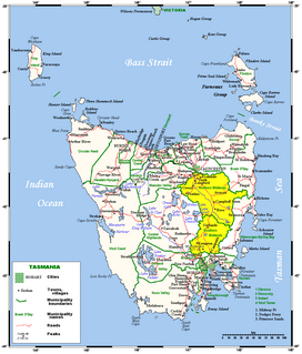
The Midlands is a region of Tasmania between Launceston and Hobart. It also refers to the relatively flat, dry agricultural area, so named because it covers the region between the two cities. Its name is probably also influenced from the Midlands in the United Kingdom. It lends its name to the Southern Midlands Council, Northern Midlands Council, and the Midland Highway. The region is sometimes conflated or confused with the adjacent region of the Central Highlands—with the added term Tasmania's heartland.

Contents

Location and features

The Macquarie River rises below Tooms Lake, near Hobgoblin and flows generally south and then north-west and through the town of Ross before reaching its confluence with the South Esk River near Longford. The Tooms, Blackman, Elizabeth, Isis and Lake rivers all are tributaries of the Macquarie. [3] The river descends 472 metres (1,549 ft) over its 189-kilometre (117 mi) course. [1]

Tooms Lake Town in Tasmania, Australia

Tooms Lake is the name of both a lake and a village in the eastern midlands of Tasmania. The lake is artificial and shallow covering 6.6 km2 (2.5 sq mi)

Ross, Tasmania Town in Tasmania, Australia

Ross is a historic town in the Midlands of the state of Tasmania in Australia. On the Macquarie River, Ross is located 78 km south of Launceston and 117 km north of Hobart. The town is listed on the Register of the National Estate and is noted for its historic bridge, original sandstone buildings and convict history.

Confluence Meeting of two or more bodies of flowing water

In geography, a confluence occurs where two or more flowing bodies of water join together to form a single channel. A confluence can occur in several configurations: at the point where a tributary joins a larger river ; or where two streams meet to become the source of a river of a new name ; or where two separated channels of a river rejoin at the downstream end.

The traditional custodians of the Macquarie River Valley were the Tyerrernotepanner (chera-noti-pahner) Clan of the North Midlands Nation. [4] The Tyerrernotepanner were a nomadic people who traversed country from the Central Plateau to the Eastern Tiers but were recorded as inhabiting 'resorts' in the Macquarie Valley at Ross, Ellenthorpe Hall, Glen Morriston and Tooms Lake/moyentaliah. [5]

See also

Related Research Articles

Protected areas of Tasmania consists of protected areas located within Tasmania and its immediate onshore waters, including Macquarie Island. It includes areas of crown land managed by Tasmanian Government agencies as well as private reserves. As of 2016, 52% of Tasmania's land area has some form of reservation classification, the majority is managed by the Tasmania Parks & Wildlife Service. Marine protected areas cover about 7.9% of state waters.

Aboriginal Tasmanians ethnic group

The Aboriginal Tasmanians are the Aboriginal people of the Australian state of Tasmania, located south of the mainland. For much of the 20th century, the Tasmanian Aboriginal people were widely, and erroneously, thought of as being an extinct cultural and ethnic group. Contemporary figures (2016) for the number of people of Tasmanian Aboriginal descent vary according to the criteria used to determine this identity, ranging from 6,000 to over 23,000.

Launceston, Tasmania City in Tasmania, Australia

Launceston is a city in the north of Tasmania, Australia, at the junction of the North Esk and South Esk rivers where they become the Tamar River (kanamaluka). Launceston is the second most populous city in Tasmania after the state capital, Hobart, and the twelfth-largest non-capital city in Australia.

Ben Lomond (Tasmania) plateau in the north of Tasmania

Ben Lomond is a mountain in the north-east of Tasmania, Australia.

Deddington, Tasmania Town in Tasmania, Australia

Deddington is a town near Evandale in Tasmania, Australia. The town is situated on the Nile River and lies in the foothills of Ben Lomond.

South Esk River river in Australia

The South Esk River, the longest river in Tasmania, is a major perennial river located in the northern region of Tasmania, Australia.

North Esk River river in northern Tasmania, Australia

The North Esk River is a major perennial river located in the northern region of Tasmania, Australia.

Evandale, Tasmania Town in Tasmania, Australia

Evandale is a historic town in northern Tasmania, Australia. It sits on the banks of the South Esk River, 18 km south of Launceston. The town is famous for its late-Georgian and early-Victorian buildings with relatively untouched streetscape, a popular Sunday market and as a host to the annual World Penny Farthing bicycle Championships. At the 2016 census, Evandale had a population of 1,345.

Electoral division of Launceston electoral division of the Tasmanian Legislative Council

The electoral division of Launceston is one of 15 electorates or seats in the Tasmanian Legislative Council, created in 2008. It also previously existed until 1999, when it was abolished and substantially incorporated into the new division of Paterson, which was in turn abolished in 2008.

Poatina Power Station dam in Central Highlands Tasmania

The Poatina Power Station is a conventional hydroelectric power station located in the Central Highlands region of Tasmania, Australia. The power station is situated on the Great Lake and South Esk and is owned and operated by Hydro Tasmania.

Trevallyn Power Station dam in Northern Midlands Tasmania

The Trevallyn Power Station is a run-of-the-river hydroelectric power station located in the northern Midlands region of Tasmania, Australia. The power station is situated on the Great Lake and South Esk catchment and is owned and operated by Hydro Tasmania.

Campbell Town, Tasmania Town in Tasmania, Australia

Campbell Town is a town in Tasmania, Australia, on the Midland Highway. At the 2006 census, the town had a population of 772.

Stacks Bluff mountain in Australia

The Stacks Bluff is a peak in northeast Tasmania, Australia. The mountain is situated on the Ben Lomond plateau.

Lake Leake, Tasmania Town in Tasmania, Australia

Lake Leake is the name of both a man-made water storage reservoir and a small township in the eastern midlands of Tasmania. The lake can hold 22.076 gigalitres (779,600,000 cu ft) of water. The lake was named after Charles Henry Leake a member of the Tasmanian Legislative Council. At the 2006 census, Lake Leake had a population of 176.

Somerset Land District Cadastral in Tasmania, Australia

Somerset Land District is one of the twenty land districts of Tasmania which are part of the Cadastral divisions of Tasmania. It was formerly one of the 18 counties of Tasmania.

This page discusses the rivers and hydrography of the state of Tasmania, Australia.

Elizabeth River (Tasmania) river in Australia

The Elizabeth River is a minor perennial river located in the Somerset Land District, in the Midlands region of Tasmania, Australia.

References

  1. 1 2 "Map of Macquarie River, TAS". Bonzle Digital Atlas of Australia. 2015. Retrieved 18 June 2016.
  2. Taylor, John (1996). "Dictionary of Palawa place names". State Library of Tasmania/Riuwanna - UTAS: 72.
  3. "Macquarie River and South Esk River Catchments". EPA Division. Department of Primary Industries, Parks, Water and Environment. Archived from the original on 20 August 2011. Retrieved 16 September 2011.
  4. Plomley, Brian (1990). Tasmanian Tribes and Cicatrices as tribal indicators among the Tasmanian Aborigines. Launceston, Tasmania: QVMAG. p. 24.
  5. Kee, Sue (1990). Midlands Aboriginal Archeological Survey. Hobart, Tasmania: National Parks, Wildlife and Heritage Occasional Paper no 28. ISBN   07246 1738 8.