Clyde River (Tasmania)

Last updated

Clyde
Eugene von GUERard - Waterfall on the Clyde River, Tasmania - Google Art Project.jpg
Relief Map of Tasmania.png
Red pog.svg
Location of the Clyde River mouth in Tasmania
Location
Country Australia
State Tasmania
Region Midlands
Settlements Bothwell, Hamilton
Physical characteristics
SourceLake Sorrell and Lake Crescent
  locationnear Interlaken
  coordinates 42°56′S146°7′E / 42.933°S 146.117°E / -42.933; 146.117
  elevation817 m (2,680 ft)
Mouth River Derwent
  location
south of Hamilton
  coordinates
42°34′47″S146°48′39″E / 42.57972°S 146.81083°E / -42.57972; 146.81083 Coordinates: 42°34′47″S146°48′39″E / 42.57972°S 146.81083°E / -42.57972; 146.81083
  elevation
73 m (240 ft)
Length97 km (60 mi)
Basin size1,120 km2 (430 sq mi)
Basin features
River system River Derwent catchment
Reservoirs Lake Sorell, Lake Crescent, Meadowbank Lake
[1]

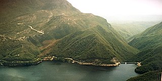
The Clyde River, also known as the River Clyde, [1] part of the River Derwent catchment, is a perennial river located in the Midlands region of Tasmania, Australia.

River Derwent (Tasmania) river in south east Tasmania, Australia

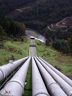
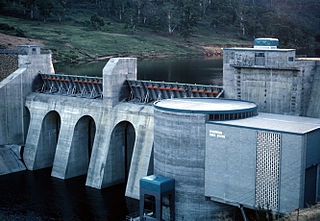
The River Derwent is a river located in Tasmania, Australia. It is also known by the palawa kani name timtumili minanya. The river rises in the state's Central Highlands at Lake St Clair, and descends more than 700 metres (2,300 ft) over a distance of more than 200 kilometres (120 mi), flowing through Hobart, the state's capital city, before emptying into Storm Bay and flowing into the Tasman Sea. The banks of the Derwent were once covered by forests and occupied by Tasmanian Aborigines. European settlers farmed the area and during the 20th century many dams were built on its tributaries for the generation of hydro-electricity.

Midlands (Tasmania) Region in Tasmania, Australia

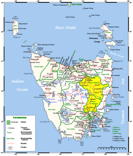
The Midlands is a region of Tasmania between Launceston and Hobart. It also refers to the relatively flat, dry agricultural area, so named because it covers the region between the two cities. Its name is probably also influenced from the Midlands in the United Kingdom. It lends its name to the Southern Midlands Council, Northern Midlands Council, and the Midland Highway. The region is sometimes conflated or confused with the adjacent region of the Central Highlands—with the added term Tasmania's heartland.

Tasmania island state of Australia

Tasmania is an island state of Australia. It is located 240 km (150 mi) to the south of the Australian mainland, separated by Bass Strait. The state encompasses the main island of Tasmania, the 26th-largest island in the world, and the surrounding 334 islands. The state has a population of around 533,308 as of March 2019. Just over forty percent of the population resides in the Greater Hobart precinct, which forms the metropolitan area of the state capital and largest city, Hobart.

Contents

Course and features

The Clyde River rises in the reservoirs of Lake Sorell and Lake Crescent, near Interlaken and flows generally west by south, through the settlements of Bothwell and Hamilton, joined by nine minor tributaries before reaching its mouth and emptying into the River Derwent at Lake Meadowbank. The river drains a catchment area of 1,120 square kilometres (430 sq mi) in an agricultural region of Tasmania [2] and descends 744 metres (2,441 ft) over its 97-kilometre (60 mi) course. [1]

Reservoir A storage space for fluids

A reservoir is, most commonly, an enlarged natural or artificial lake, pond or impoundment created using a dam or lock to store water.

Lake Crescent is a man-made reservoir located in the eastern side of the Midlands region of Tasmania, Australia, approximately 100 kilometres (62 mi) north of Hobart.

Bothwell, Tasmania Town in Tasmania, Australia

Bothwell, Tasmania is a small town with a population at the 2011 census of 391. Situated in central Tasmania on the River Clyde, it is notable for hunting and being a lake district. It is part of the municipality of Central Highlands Council. Nearby locations include Ouse, Hamilton and Kempton.

See also

Related Research Articles

Crotty Dam dam in West Coast Tasmania

The Crotty Dam, also known during construction as the King Dam, or the King River Dam on initial approval, is a rockfill embankment dam with a controlled and uncontrolled spillway across the King River, between Mount Jukes and Mount Huxley, located in Western Tasmania, Australia.

Butlers Gorge Power Station dam in Central Highlands, Tasmania

The Butlers Gorge Power Station is a conventional hydroelectric power station located in the Central Highlands region of Tasmania, Australia.

Tarraleah Power Station dam in Central Highlands, Tasmania

The Tarraleah Power Station is a hydroelectric power station located in the Central Highlands region of Tasmania, Australia. The power station is part of the Upper Derwent hydro scheme and is operated by Hydro Tasmania.

Catagunya Power Station dam in Central Highlands Tasmania

The Catagunya Power Station is a run-of-the-river hydroelectric power station located in the Central Highlands region of Tasmania, Australia. The power station is situated on the Lower River Derwent catchment and is owned and operated by Hydro Tasmania.

Liapootah Power Station dam in Central Highlands Tasmania

The Liapootah Power Station is a run-of-the-river hydroelectric power station located in the Central Highlands region of Tasmania, Australia. The power station is situated on the Lower River Derwent catchment and is owned and operated by Hydro Tasmania.

Wayatinah Power Station dam in Central Highlands Tasmania

The Wayatinah Power Station is a run-of-the-river hydroelectric power station located in the Central Highlands region of Tasmania, Australia. The power station is situated on the Lower River Derwent catchment and is owned and operated by Hydro Tasmania.

Repulse Power Station dam in Central Highlands Tasmania

The Repulse Power Station is a conventional hydroelectric power station located in the Central Highlands region of Tasmania, Australia. The power station is situated on the Lower River Derwent catchment and is owned and operated by Hydro Tasmania.

Meadowbank Power Station dam in Central Highlands Tasmania

The Meadowbank Power Station is a run-of-the-river hydroelectric power station located in the Central Highlands region of Tasmania, Australia. The power station is situated on the Lower River Derwent catchment and is owned and operated by Hydro Tasmania.

Tungatinah Power Station dam in Central Highlands, Tasmania

The Tungatinah Power Station is a conventional hydroelectric power station located in the Central Highlands region of Tasmania, Australia. The power station is situated on the Upper River Derwent catchment and is owned and operated by Hydro Tasmania.

Lake Echo Power Station dam in Central Highlands, Tasmania

The Lake Echo Power Station is a conventional hydroelectric power station located in the Central Highlands region of Tasmania, Australia. The power station is situated on the Upper River Derwent catchment and is owned and operated by Hydro Tasmania.

Mackintosh River river in Australia

The Mackintosh River, part of the Pieman River catchment, is a major perennial river located in the West Coast region of Tasmania, Australia.

Cumberland Land District Cadastral in Tasmania, Australia

Cumberland Land District is one of the twenty land districts of Tasmania which are part of the cadastral divisions of Tasmania. It was formerly one of the 18 counties of Tasmania. It is bordered by the River Derwent to the south, the Clyde River to the east, with Lake Sorell at the north-eastern edge. The Nive River is the boundary to the west. Part of the Shannon River is a section of the boundary to the north, with Great Lake on the northern edge.

Sophia River river in Australia

The Sophia River, part of the Pieman River catchment, is a perennial river located in the West Coast region of Tasmania, Australia.

This page discusses the rivers and hydrography of the state of Tasmania, Australia.

Jordan River (Tasmania) river in Australia

The Jordan River is a perennial river located in the Midlands region of Tasmania, Australia.

Lake Murchison lake in the West Coast Range, Western Tasmania, Australia

Lake Murchison is a man-made water reservoir located in the western region of Tasmania, Australia. The lake is situated within the northern part of Tasmania's West Coast Range and is fed by the Murchison River, the George Creek, the Anthony River, and discharge from the Tribute Power Station.

Nieterana Power Station dam in Central Highlands, Tasmania

The Nieterana Power Station is a small hydroelectric power station located in the Central Highlands region of Tasmania, Australia.

Boyd River (Tasmania) tributary of the Wedge River in Tasmania, Australia

The Boyd River, part of the Gordon River catchment, is a perennial river located in the south western region of Tasmania, Australia.

References

  1. 1 2 3 "Map of River Clyde, TAS". Bonzle Digital Atlas of Australia. 2015. Retrieved 30 June 2015.
  2. "2005 Waterways Monitoring Report - Clyde Catchment" (PDF). Department of Water, Primary Industries and the Environment. Tasmania: Tasmanian Government. 2005.