This page discusses the rivers and hydrography of the state of Tasmania, Australia.
In the geography of Tasmania, the state is covered with a network of rivers and lake systems. As an island, all rivers eventually empty into the waters that surround Tasmania. There are four main river systems: [1]
Compared to the rest of Australia, [2] Tasmania has a very high proportion of wild or undisturbed rivers. [3] [4]
Major catchments of Tasmania are linked to the major rivers, the most notable being the Derwent. Catchments by region are:
The following rivers are the longest river systems, by length. [1]
| Order | River name | Length | Region(s) | |
|---|---|---|---|---|
| km | mi | |||
| 1 | South Esk | 252 | 157 | Midlands |
| 2 | Derwent | 215 | 134 | Central Highlands |
| 3 | Arthur | 189 | 117 | West Coast |
| 4 | Gordon | 186 | 116 | Central Highlands; South-west; Western |
| 5 | Huon | 169 | 105 | South-west |
| 6 | Mersey | 158 | 98 | North-west |
| 7 | Franklin | 129 | 80 | Central Highlands; West Coast |
| 8 | North Esk | 97 | 60 | Northern |
| 9 | Pieman | 38 | 24 | West Coast |
D'Entrecasteaux (Derwent) sub-catchment | D'Entrecasteaux (Huon) sub-catchment | Rivers with no defined sub-catchment |
Gordon–Franklin sub-catchment | Pieman River sub-catchment | Davey River sub-catchmentHenty River sub-catchmentKing River sub-catchmentOld River sub-catchmentWanderer River sub-catchment | Rivers with no defined sub-catchment |
Esk–Tamar catchment | Arthur River sub-catchmentInglis River sub-catchment
| Forth River sub-catchmentMersey River sub-catchmentCam River sub-catchment
| Rivers with no defined sub-catchment |

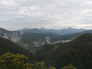
Southwest National Park is an Australian national park located in the south-west of Tasmania, bounded by the Franklin-Gordon Wild Rivers National Park to the north and the Hartz Mountains National Park to the east. It is a part of a chain of national parks and state reserves that make up the Tasmanian Wilderness World Heritage Area. Covering an area of 6,183 km2 (2,387 sq mi), it is Tasmania's largest national park.

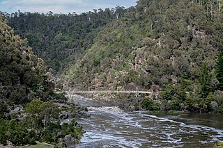
The River Derwent is a river located in Tasmania, Australia. The river rises in the state's Central Highlands at Lake St Clair, and descends more than 700 metres (2,300 ft) over a distance of more than 200 kilometres (120 mi), flowing through Hobart, the state's capital city, before emptying into Storm Bay and flowing into the Tasman Sea. The banks of the Derwent were once covered by forests and occupied by Aboriginal Tasmanians. European settlers farmed the area and during the 20th century many dams were built on its tributaries for the generation of hydro-electricity.

Lake Pedder, once a glacial outwash lake, is a man-made impoundment and diversion lake located in the southwest of Tasmania, Australia. In addition to its natural catchment from the Frankland Range, the lake is formed by the 1972 damming of the Serpentine and Huon rivers by the Hydro Electric Commission of Tasmania for the purposes of hydroelectric power generation.

The Gordon River is a major perennial river located in the central highlands, south-west, and western regions of Tasmania, Australia.

The Meander River is a major perennial river located in the central northern region of Tasmania, Australia. Until the founding of Westbury in the early 1820s, the river was known as The Western River.
Strathgordon is a rural locality in the local government area (LGA) of Derwent Valley in the South-east LGA region of Tasmania. The locality is about 121 kilometres (75 mi) west of the town of New Norfolk. The 2016 census recorded a population of 15 for the state suburb of Southwest, which includes Strathgordon. It is on the road to the Gordon River dam the most south westerly road in the south west of Tasmania. It is a tourist destination for visitors wishing to visit the Southwest National Park and World Heritage listed wilderness.

The Huon River is a perennial river located in the south-west and south-east regions of Tasmania, Australia. At 174 kilometres (108 mi) in length, the Huon River is the fifth-longest in the state, with its course flowing east through the fertile Huon Valley and emptying into the D'Entrecasteaux Channel, before flowing into the Tasman Sea.
The South Esk River, the longest river in Tasmania, is a major perennial river located in the northern region of Tasmania, Australia.

The D'Entrecasteaux Channel is a body of water located between Bruny Island and the south-east of the mainland of Tasmania, Australia. The channel is the mouth for the estuaries of the Derwent and the Huon Rivers and empties into the Tasman Sea of the South Pacific Ocean. It was sighted by Abel Tasman in 1642 and surveyed in 1792 by Bruni d'Entrecasteaux.
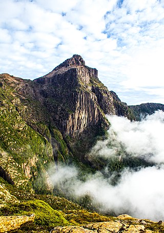
South West Tasmania is a region in Tasmania that has evoked curiosity and wonder during the period of European presence on the island.
Bathurst Harbour is a shallow bay located in the south west region of Tasmania, Australia. Bathurst Harbour is contained within the Port Davey/Bathurst Harbour Marine Nature Reserve, and the Southwest National Park, part of the Tasmanian Wilderness World Heritage Area.

The Clyde River, also known as the River Clyde, part of the River Derwent catchment, is a perennial river located in the Midlands region of Tasmania, Australia.
The Gordon River Road, sometimes called the Strathgordon Road, (B61), is a road in the south western region of Tasmania, Australia.
The Serpentine River is a major perennial river located in the south-west and western regions of Tasmania, Australia.
The Scotts Peak Dam Road is the most southerly point of road access into Southwest National Park, Tasmania, Australia.
The Scotts Peak Dam is a rockfill embankment dam without a spillway across the Huon River, located in the South West region of Tasmania, Australia.
The Serpentine Dam is a rockfill embankment dam with a concrete face and a controlled spillway across the Serpentine River, located in the South West region of Tasmania, Australia.
The Edgar Dam is an earthfill embankment saddle dam without a spillway, located offstream in the South West region of Tasmania, Australia.
The Anthony Power Development Scheme, part of the Pieman River power development scheme, was a proposed scheme for damming parts of the upper catchment of the Pieman River in Western Tasmania, Australia.
The Anthony River, part of the Pieman River catchment, is a perennial river in the West Coast region of Tasmania, Australia.