Related Research Articles
Protected areas of Tasmania consist of protected areas located within Tasmania and its immediate onshore waters, including Macquarie Island. It includes areas of crown land managed by Tasmanian Government agencies as well as private reserves. As of 2016, 52% of Tasmania's land area has some form of reservation classification, the majority is managed by the Tasmania Parks & Wildlife Service. Marine protected areas cover about 7.9% of state waters.

Douglas-Apsley is a national park and a locality on the east coast of Tasmania, Australia, 149 km northeast of Hobart, and a few kilometres north of Bicheno. It is one of Tasmania's newer National Parks, having been declared on 27 December 1989.

Hartz Mountains National Park is located in the south of Tasmania, Australia. It is one of 19 Tasmanian National Parks, and in 1989 it was included in the Tasmanian Wilderness World Heritage Area, in recognition of its natural and cultural values. The Hartz Mountains were named after the Harz mountain range in Germany.

The Overland Track is an Australian bushwalking track, traversing Cradle Mountain-Lake St Clair National Park, within the Tasmanian Wilderness World Heritage Area. It is walked by more than nine thousand people each year, with numbers limited in the warmer months. Officially the track runs for 65 kilometres (40 mi) from Cradle Mountain to Lake St Clair however many choose to extend it by walking along Lake St Clair for an extra day, bringing it to 82 kilometres (51 mi). It winds through terrain ranging from glacial mountains, temperate rainforest, wild rivers and alpine plains.
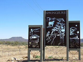
Springsure is a rural town and locality in the Central Highlands Region, Queensland, Australia. In the 2021 census, the locality of Springsure had a population of 950 people.

Maria Island or wukaluwikiwayna in palawa kani is a mountainous island located in the Tasman Sea, off the east coast of Tasmania, Australia. The 115.5-square-kilometre (44.6 sq mi) island is entirely occupied by the Maria Island National Park, which includes a marine area of 18.78 square kilometres (7.25 sq mi) off the island's northwest coast. The island is about 20 kilometres (12 mi) in length from north to south and, at its widest, is about 13 kilometres (8.1 mi) west to east. At its closest point, Point Lesueur, the island lies approximately 4 kilometres (2.5 mi) off the east coast of Tasmania and is connected by ferry with Triabunna.

Frenchmans Cap is a mountain in the West Coast region of Tasmania, Australia. The mountain is situated in the Franklin-Gordon Wild Rivers National Park.

The Eldon Range is a mountain range located in the west coast region of Tasmania, Australia.

Tasmania Parks and Wildlife Service is the government body responsible for managing protected areas of Tasmania on public land, such as national parks, historic sites and regional reserves. Historically it has also had responsibility for managing wildlife, including game.
Cloudy Bay is located at the southernmost end of Bruny Island in the Australian state of Tasmania, inside South Bruny National Park.
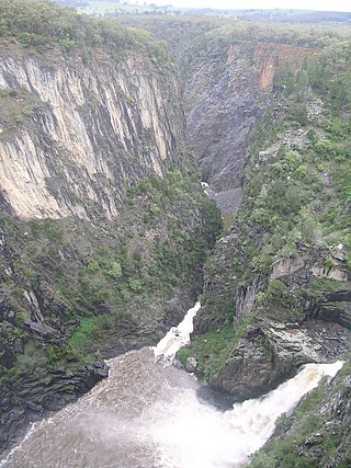
The Apsley Falls are two waterfalls on the Apsley River in the Northern Tablelands region of New South Wales, Australia. The falls are located about 20 kilometres (12 mi) east of Walcha, and 1 kilometre off the Oxley Highway in a deep gorge, that is part of the Oxley Wild Rivers National Park. They are the first falls in a succession of dramatic drops in an area that has some of the most remarkable scenery in Eastern Australia. The first drop of the falls is about 65 metres (213 ft) in depth, and the second, which is about 800 metres (2,625 ft) further on, plummets 58 metres (190 ft) to the bottom of the gorge.
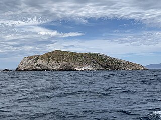
Ile des Phoques is a rugged granite island, with an area of 8 ha, part of the Schouten Island Group, lying close to the eastern coast of Tasmania, Australia near the Freycinet Peninsula.

Apsley River, a perennial stream of the Macleay River catchment, is located in the Northern Tablelands district of New South Wales, Australia.

Great Oyster Bay is a broad and sheltered bay on the east coast of Tasmania, Australia which opens onto the Tasman Sea. The Tasman Highway runs close to the West Coast of the bay with views of the granite peaks of the Hazards and Schouten Island of the Freycinet Peninsula which are incorporated in the Freycinet National Park.

The Bay of Fires is a bay on the northeastern coast of Tasmania in Australia, extending from Binalong Bay to Eddystone Point. The bay was given its name in 1773 by Captain Tobias Furneaux in Adventure, who saw the fires of Aboriginal people on the beaches.
The Port Davey Track, officially the Old Port Davey Track, is a bushwalking track located in the south western region of Tasmania, Australia. The 70-kilometre (43 mi) track traverses remote wilderness within the Southwest National Park, part of the Tasmanian Wilderness World Heritage Site, and is managed as a wilderness walk. The Tasmanian Parks & Wildlife Service recommend that experienced bushwalkers can take four-to-five days to cover the track in one direction.

Moulting Lagoon Important Bird Area is a composite wetland site in eastern Tasmania, Australia. It comprises two adjacent and hydrologically continuous wetlands – Moulting Lagoon and the Apsley Marshes – at the head of Great Oyster Bay, near the base of the Freycinet Peninsula, between the towns of Swansea and Bicheno. Both components of the site are listed separately under the Ramsar Convention as wetlands of international significance. Moulting Lagoon is so named because it is a traditional moulting place for black swans. It is an important site for waterbirds.

Logan Lagoon is a 2172 ha wetland Conservation Area on Flinders Island, the largest of the Furneaux Group at the eastern end of Bass Strait, which is part of the Australian state of Tasmania.
The Djangadi people, also spelt Dhungatti, Dainggati, Tunggutti or Dunghutti are an Aboriginal Australian people resident in the Macleay Valley of northern New South Wales.
Epacris limbata, commonly known as bordered heath or border heath, is a species of flowering plant in the heath family Ericaceae and is endemic to a restricted area of Tasmania. It is an erect shrub with narrowly heart-shaped or broadly egg-shaped, stem-clasping, sharply-pointed leaves and tube-shaped white flowers clustered along the ends of branches.
References
- ↑ "A GENERAL RAIN". The Mercury . Vol. CXVI, no. 17, 054. Tasmania, Australia. 31 May 1922. p. 8. Retrieved 8 April 2024– via National Library of Australia.
- ↑ Dombrovskis, Peter (1989), Pink berry fruits at Apsley River, Tasmania, 1989 , retrieved 8 April 2024
- ↑ "Douglas-Apsley National Park | Tasmania Travel Guide". Tasmania. Retrieved 2024-04-07.
- ↑ "Apsley River Waterhole and Gorge | Parks & Wildlife Service Tasmania". parks.tas.gov.au. Retrieved 2024-04-07.
- ↑ Tasmania. Parks and Wildlife Service (1994), Apsley River visitor services zone site plan, Parks and Wildlife Service, retrieved 8 April 2024
41°59′19″S148°13′03″E / 41.9885°S 148.2174°E