
The Prosser River is a river in Tasmania, Australia. The river flows into the Tasman Sea.
The Prosser River is a river in Tasmania, Australia. The river flows into the Tasman Sea.
The Prosser River Reserve is home to at least 11 at-risk plant and animal species. [1] The Prosser River is virtually unnavigable except at maximum tide. [2] The Old Convict Road trail follows the northern side of the Prosser River for 1km. [3]
The river gives its name to the electoral division of Prosser. [4]

Risdon Cove is a cove located on the east bank of the Derwent River, approximately 7 kilometres (4 mi) north of Hobart, Tasmania. It was the site of the first British settlement in Van Diemen's Land, now Tasmania, the island state of Australia. The cove was named by John Hayes, who mapped the river in the ship Duke of Clarence in 1794, after his second officer William Bellamy Risdon.

The Parliament of Tasmania is the bicameral legislature of the Australian state of Tasmania. It follows a Westminster-derived parliamentary system and consists of the governor of Tasmania, the Legislative Council, and the House of Assembly. Since 1841, both Houses have met in Parliament House, Hobart. The Parliament of Tasmania first met in 1856.

Orford is a village on the east coast of Tasmania, Australia 73 kilometres north-east of Hobart. It is the home of the joint champions of T20 Cricket in Tasmania. The village is centred on the mouth of the Prosser River, on the southern margin of a substantial coastal inlet called Prosser Bay. Beyond this bay are the waters of the Mercury Passage. At the 2006 census, Orford had a population of 553.
Derwent Barracks is an Australian Army barracks in the Hobart suburb of Glenorchy, near the Elwick Racecourse and Hobart Showgrounds. It is named after the nearby Derwent River. It is the home of several Army Reserve units including:
Prince of Wales Bay is located on the western shore of the River Derwent in southern Tasmania, Australia.
Elwick Road is a major arterial road that runs through the northern suburbs of Hobart, Tasmania. The road is the major link road between the Main Road and the Brooker Highway that connects to Glenorchy. Elwick passes through residential areas.

The Red Bridge in Tasmania crosses the Elizabeth River at Campbell Town. Built in 1838 using penal labour, it is the oldest surviving brick arch bridge in Australia, as well as the oldest bridge anywhere on the National Highway. The bridge contains three arch spans of 7.6 m (25 ft) each and holds two lanes of traffic as well as pedestrian walkways. It lies on the Midland Highway, roughly halfway between Hobart and Launceston, carrying over two million vehicles per year.

Great Oyster Bay is a broad and sheltered bay on the east coast of Tasmania, Australia which opens onto the Tasman Sea. The Tasman Highway runs close to the West Coast of the bay with views of the granite peaks of the Hazards and Schouten Island of the Freycinet Peninsula which are incorporated in the Freycinet National Park.
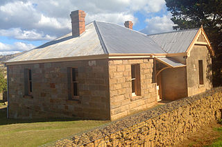
The Ross Female Factory, a former Australian workhouse for female convicts in the penal colony of Van Diemen's Land, is located in the village of Ross, in the midlands region of Tasmania. The site was operational between 1848 and 1854.
The Interlaken Lakeside Reserve is a wetland reserve at subalpine Interlaken, lying at the north-western end of Lake Crescent on the Interlaken isthmus between the reservoirs of Lakes Sorell and Crescent, about 20 km west of Tunbridge, in the Central Highlands of Tasmania, Australia. In 1982 it was designated a wetland of international importance under the Ramsar Convention.
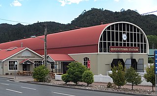
Queenstown in Western Tasmania has had two railway stations. The original was built for the railway built for the Mount Lyell Mining and Railway Company, and lasted until the closing of the railway line in 1962. The newer station was built for the re-built railway, the West Coast Wilderness Railway.

Holy Trinity Church is a former Anglican, and now Greek Orthodox, church in North Hobart, Tasmania.
St. Peter's Lutheran Church (SPLC) is located in Warrane, Tasmania. The church's denomination is Lutheran and has approximately 140 members. The Lutheran school associated with St Peter's Church was moved to Warrane in 1982. The church followed a number of years later. In addition to worship services and the church's related religious education and fellowship program, the church has multiple events throughout the year such as the Easter breakfast on Mt Wellington and a Christmas pageant. SPLC is a part of the Victorian-Tasmanian district of the Lutheran Church of Australia.

Mount Misery is the dominant feature overlooking Huonville in southern Tasmania. With an elevation of 690 metres (2,260 ft), it is typical of most of the peaks surrounding Huonville; but its location on a bend of the Huon River makes it the dominant feature in many tourist photos.

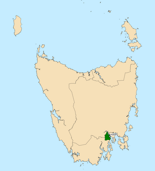
The electoral division of Prosser is one of the fifteen electorates in the Tasmanian Legislative Council, it includes the south-east coast of Tasmania, the Sorell township and the Tasman Peninsula. Prosser is named after the Prosser River, which flows through the centre of the division.
The Division of Clark is an Australian Electoral Division in the state of Tasmania, first contested at the 2019 federal election.
The electoral division of Clark is one of the five electorates in the Tasmanian House of Assembly, it is located in Hobart on the western shore of the River Derwent and includes the suburbs below Mount Wellington. Clark is named after Andrew Inglis Clark, a Tasmanian jurist who was the principal author of the Australian Constitution. The electorate shares its name and boundaries with the federal division of Clark.
Jane Colleen Howlett is an Australian politician, who was a Liberal member of the Tasmanian Legislative Council for the division of Prosser and is now member for the Division of Lyons (state).
Periodic elections for the Tasmanian Legislative Council were held on 4 May 2024. The two seats up for periodic election were Hobart and Prosser. A by-election for the seat of Elwick was also held concurrently.
This is a list of members of the Tasmanian Legislative Council between 2023 and 2029. Terms of the Legislative Council did not coincide with Legislative Assembly elections, and members served six year terms, with a number of members facing election each year.
42°33′15″S147°52′47″E / 42.5541°S 147.8798°E