Councils of Tasmania are the 29 administrative districts of the Australian state of Tasmania. Local government areas (LGAs), more generally known as councils, are the tier of government responsible for the management of local duties such as road maintenance, town planning and waste management.
Waratah-Wynyard Council is a local government body in Tasmania, situated in the north-west of the state. Waratah-Wynyard is classified as a rural local government area and has a population of 13,800, the major towns and localities of the region include Savage River, Sisters Beach, Somerset, Waratah and the principal town of Wynyard.
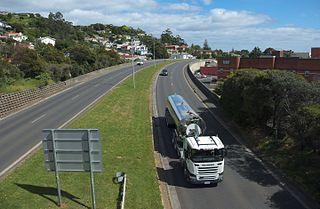
The Bass Highway is a highway in Tasmania, Australia. It connects the three cities across the north of the state – Burnie, Devonport and Launceston. The road was named due to its proximity to the Bass Strait. It is a part of the National Highway, designated as National Highway 1, together with the Midland and Brooker highways in Tasmania.

Wynyard (/ˈwɪnjɚd/) wi-nyuhd) is a rural town located on the North West coast of Tasmania, Australia. Wynyard is situated 17 kilometres (11 mi) west of Burnie. As of the 2021 census, Wynyard has an estimated population of 6,296 The town is a regional hub servicing the surrounding rural areas, the adjacent Burnie Wynyard Airport provides commercial flights to Melbourne and other districts. The main council offices for the Waratah-Wynyard local government area are located in Wynyard.

Somerset is a small township to the west of Burnie, Tasmania, Australia, which shares its name with the County of Somerset, England, UK. Today the city of Burnie encompasses the entire Burnie-Somerset urban area; however, the town is part of the Waratah/Wynyard municipal area.

The Division of Braddon is an Australian electoral division in the state of Tasmania. The current MP is Gavin Pearce of the Liberal Party, who was elected at the 2019 federal election.
The Eldon Range is a mountain range located in the west coast region of Tasmania, Australia.
Guildford is a rural locality in the local government area (LGA) of Waratah–Wynyard in the North-west and west LGA region of Tasmania. The locality is about 81 kilometres (50 mi) south of the town of Wynyard. The 2016 census has a population of nil for the state suburb of Guildford.

Burnie City Council is a local government body in Tasmania, located in the city and surrounds of Burnie in the north-west of the state. The Burnie local government area is classified as urban and has a population of 19,348, which also encompasses Cooee, Hampshire, Natone and Ridgley.
Boat Harbour is a rural locality in the local government area (LGA) of Waratah–Wynyard in the North-west and west LGA region of Tasmania. The locality is about 11 kilometres (6.8 mi) north-west of the town of Wynyard. The 2016 census has a population of 273 for the state suburb of Boat Harbour.
Hampshire is a semi-rural locality in the local government areas (LGA) of Waratah Wynyard and Burnie in the North-west and west LGA region of Tasmania. The locality is about 30 kilometres (19 mi) south-west of the town of Burnie. The 2016 census has a population of 51 for the state suburb of Hampshire.

North West Tasmania is one of the regions of Tasmania in Australia. The region comprises the whole of the north west, including the North West Coast and the northern reaches of the West Coast. It is usually accepted as extending as far south as the Pieman River and including the Savage River National Park within the Tarkine region.
The Raglan Range is located in Western Tasmania, east of the West Coast Range.

Table Cape is a extinct volcano located near Wynyard on the North West of Tasmania, Australia, it is also the name of the locality which encompasses the geological feature. Table Cape is a more or less circular extinct volcano with a flat top, its northern and eastern faces rise steeply from Bass Strait to a height of approximately 170 metres (560 ft) above sea level. It was named by British navigator, Matthew Flinders, as he and George Bass circumnavigated Van Diemen's Land in 1798 upon the Norfolk. Flinders also progressively named the nearby Circular Head, Three Hummock and Hunter Islands.
Camdale is a locality and small rural community in the local government area of Burnie, in the North West region of Tasmania. It is located about 7.5 kilometres (4.7 mi) west of the town of Burnie. The Cam River forms its western boundary, Bass Strait the northern boundary, and the Bass Highway follows the northern boundary. The 2016 census determined a population of 72 for the state suburb of Camdale.
Mount Hicks is a locality and small rural community in the local government area of Waratah-Wynyard in the North West region of Tasmania. It is located about 13 kilometres (8.1 mi) south of the town of Wynyard. The 2016 census determined a population of 351 people for the state suburb of Mount Hicks.
Oonah is a rural locality in the local government areas of Burnie and Waratah-Wynyard in the North West region of Tasmania. It is located about 38 kilometres (24 mi) south-west of the town of Burnie. The 2016 census determined a population of nil for the state suburb of Oonah.
Henrietta is a rural locality in the local government area of Waratah-Wynyard in the North West region of Tasmania. It is located about 25 kilometres (16 mi) south of the town of Wynyard. The 2016 census determined a population of 132 for the state suburb of Henrietta.
Elliott is a rural locality in the local government area of Waratah-Wynyard in the North West region of Tasmania. It is located about 21 kilometres (13 mi) south-east of the town of Wynyard. The 2016 census determined a population of 352 for the state suburb of Elliott.
Parrawe is a rural locality in the local government areas (LGA) of Burnie and Waratah–Wynyard in the North-west and west LGA region of Tasmania. The locality is about 58 kilometres (36 mi) south-west of the town of Burnie. The 2016 census recorded a population of nil for the state suburb of Parrawe.

