
Deua is a national park located in New South Wales, Australia, 320 kilometres (200 mi) south of Sydney, and 100 kilometres (62 mi) east of Canberra. The nearest towns on the coast are Batemans Bay, Moruya and Narooma.

The Yengo National Park is a protected national park that is located in the Lower Hunter region of New South Wales, in eastern Australia. The 154,328-hectare (381,350-acre) park is situated 85 kilometres (53 mi) northwest of the Sydney central business district, 40 kilometres (25 mi) south of Cessnock, 40 kilometres (25 mi) north of Wisemans Ferry, and 155 kilometres (96 mi) southwest of Newcastle. The average elevation of the terrain is 309 meters.
Lilyfield is a suburb in the Inner West of Sydney, in the state of New South Wales, Australia. Lilyfield is located 6 kilometres west of the Sydney central business district, in the local government area of the Inner West Council.

Erskineville is an inner-city suburb of Sydney, in the state of New South Wales, Australia. It is located 6 kilometres south west of the Sydney central business district and is part of the local government area of the City of Sydney. Erskineville is a diverse suburb homing to a wide variety of ethnicity from its varying Southeast Europe and Aboriginal community. Erskineville is colloquially known as Erko.
Picnic Point, a suburb of local government area City of Canterbury-Bankstown, is 23 kilometres south-west of the Sydney central business district, in the state of New South Wales, Australia. It is a part of South-western Sydney region. Picnic Point is a residential suburb on the northern bank of the Georges River. Located within Picnic Point is Yeramba Lagoon which is the largest tract of National Park within the Canterbury – Bankstown Council, it is home to numerous species of native fauna and flora.

Araluen is a small town near Braidwood in the Southern Tablelands of New South Wales, Australia, in Queanbeyan-Palerang Regional Council. It lies in the valley of Araluen Creek, that joins the Deua River at roughly the midpoint in its course. At the 2021 census, Araluen had a population of 209 people.

Abernethy is a small town in the City of Cessnock, in the Hunter Region in the state of New South Wales, Australia. Abernethy is located 8 kilometres south-east of the town of Cessnock, NSW and is adjacent to Werakata National Park and the Aberdare State Forest. The town was founded near a coal mine and some of the historic buildings remain. In 2016 348 lived there with the median age being 32 and 74.8% being born in Australia.

Fitzroy Falls is a village in the Wingecarribee Shire, located within the Southern Highlands region of New South Wales, Australia. The locality was known as Yarrunga, but was renamed after the 81-metre (266 ft) waterfall.
Buckenbowra River, a perennial river of the Clyde River catchment, is located in the upper ranges of the South Coast region of New South Wales, Australia.

Abermain is a town 8 km ENE of Cessnock and 3 km west of Weston, in New South Wales, Australia. Abermain is adjacent to Werakata National Park.

Woolooga is a rural town and locality in the Gympie Region, Queensland, Australia. In the 2016 census the locality of Woolooga had a population of 247 people.
Araluen Creek, a partly perennial stream of the Moruya River catchment, is located in the Southern Tablelands and South Coast regions of New South Wales, Australia.
Pureba is a locality in the Australian state of South Australia located on the west coast of Eyre Peninsula and on land to the immediate north of the peninsula about 528 kilometres north-west of the state capital of Adelaide and about 52 kilometres north-east and 90 kilometres north respectively of the municipal seats of Ceduna and Streaky Bay.
Rye Park is a town in the Southern Tablelands region of New South Wales, Australia. The town is in the Hilltops Council local government area, 305 kilometres (190 mi) south west of the state capital, Sydney and 107 kilometres (66 mi) north of the national capital, Canberra.

Palerang is a locality in Queanbeyan-Palerang Regional Council, New South Wales, Australia. The town lies 55 km east of Canberra on the Palerang range. At the 2016 census, it had a population of none. It includes part of the Tallaganda National Park and State Conservation Area.

Merricumbene is a locality in the Eurobodalla Shire, New South Wales, Australia. It is located about 43 km south of Braidwood and 40 km northwest of Moruya in the valley of the Deua River. At the 2016 census, it had a population of 19.

Deua River Valley is a locality in the Eurobodalla Shire, New South Wales, Australia. It is located about 20 km northwest of Moruya on the road to Araluen in the valley of the Deua River. At the 2016 census, it had a population of 76. Much of its territory lies in the Deua National Park.

Kiora is a locality in the Eurobodalla Shire, New South Wales, Australia. It is located about 11 km west of Moruya on the road to Araluen at the point where the Deua River becomes estuarine and changes its name to the Moruya River. At the 2016 census, it had a population of 54. Its name derives from the Kiora House, which belonged to John Hawdon. It had a public school from 1868 to 1928.
Yarrangobilly, New South Wales is a rural locality in the Snowy Mountains, west of Canberra, Australia, and is also a civil Parish of Buccleuch County.
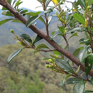
Pomaderris gilmourii is a species of flowering plant in the family Rhamnaceae and is endemic to Deua National Park in New South Wales. It is a shrub with hairy young stems, egg-shaped to elliptic leaves, and clusters of silvery buds and creamy-yellow flowers.


