The Molonglo River, a perennial river that is part of the Murrumbidgee catchment within the Murray–Darling basin, is located in the Monaro and Capital Country regions of New South Wales and the Australian Capital Territory, in Australia.

Queanbeyan is a city in the south-eastern region of New South Wales, Australia, located adjacent to the Australian Capital Territory in the Southern Tablelands region. Located on the Queanbeyan River, the city is the council seat of the Queanbeyan-Palerang Regional Council. At the 2016 census, the Queanbeyan part of the Canberra–Queanbeyan built-up area had a population of 36,348.

Kings Highway is an interstate highway located within the Australian Capital Territory and New South Wales, Australia. The highway connects Canberra with Batemans Bay on the South Coast. It is designated route B52.
Queanbeyan City was a local government area located in south eastern New South Wales, Australia. The former area is located adjacent to Canberra and the Australian Capital Territory, the Queanbeyan River, the Molonglo River, the Kings Highway and the Sydney-Canberra railway.
Michelago is a village in the Monaro region of New South Wales, Australia. The village is in the Snowy Monaro Regional Council local government area, 54 kilometres (34 mi) south of Canberra on the Monaro Highway. It was founded in the 1820s, on the main route from Sydney to the Snowy Mountains. At the 2016 census, Michelago had a population of 562.

The Queanbeyan River, a perennial stream that is part of the Molonglo catchment within the Murray–Darling basin, is located in the Monaro and Capital Country regions of New South Wales and the Australian Capital Territory, in Australia. The river is 104 kilometres (65 mi) in length with a catchment area of 96,000 hectares. The Queanbeyan River and the Cotter River meet the potable water supply needs of the Canberra and Queanbeyan region and whose water quality is specifically protected under Federal legislation.

The geology of the Australian Capital Territory includes rocks dating from the Ordovician around 480 million years ago, whilst most rocks are from the Silurian. During the Ordovician period the region—along with most of eastern Australia—was part of the ocean floor. The area contains the Pittman Formation consisting largely of Quartz-rich sandstone, siltstone and shale; the Adaminaby Beds and the Acton Shale.

Williamsdale is the name sometimes given to the unbounded locality situated immediately on the north-west side of the Australian Capital Territory border abutting the locality of Williamsdale in the Southern Tablelands region of New South Wales, Australia. The Monaro Highway and the former Bombala railway pass through the area. A railway station saw service until 1975. The postcode is 2620. The Australian Capital Territory portion is located in the District of Tuggeranong.

The Palerang Council was a local government area located in the Southern Tablelands region of New South Wales, Australia. On 12 May 2016 the Minister for Local Government announced dissolution of the Palerang Council with immediate effect. Together with Queanbeyan City the combined council areas were merged to establish the Queanbeyan-Palerang Regional Council. Both councils had opposed the amalgamation. Elections for the new Council area were held in September 2017. The former mayor of Queanbeyan City Council was appointed by the NSW Government as administrator until that date.
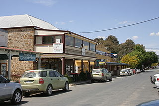
Bungendore is a town in the Queanbeyan Region of New South Wales, Australia, in Queanbeyan-Palerang Regional Council. It is on the Kings Highway near Lake George, the Molonglo River Valley and the Australian Capital Territory border. It has become a major tourist centre in recent years, popular with visitors from Canberra and some of it has heritage protection. It has expanded rapidly in recent years as a dormitory town of Canberra.

Googong is a locality located within the Queanbeyan–Palerang Regional Council government area, south of the Queanbeyan Central Business District (CBD).

The Bombala railway line is a branch railway line in the south of New South Wales, Australia. The northern part of it forms part of the main line from Sydney to Canberra, but the southern part is closed. It branches off the Main South line at Joppa Junction, south of Goulburn. The line is used by NSW TrainLink Xplorer services running between Sydney Central and Canberra station.

London Bridge is a limestone karst hollowed out by Burra Creek, a tributary of the Queanbeyan River of the Molonglo River, located near Queanbeyan, in New South Wales, near Canberra, Australia. It is now isolated as a meander cutoff and consists of a limestone arch. The arch was listed on Register of the National Estate.
Williamsdale is a locality situated immediately on the south-east side of the New South Wales border abutting the locality of Williamsdale in south-eastern Australian Capital Territory, Australia. The Monaro Highway and the former Bombala railway pass through the village. A railway station saw service from 1891 until 1975. The postcode is 2620.

The South Eastern Highlands is an interim Australian bioregion in eastern Australia, that spans parts of the states and territories of New South Wales, the Australian Capital Territory, and Victoria. The bioregion comprises 8,375,961 hectares and is approximately 3,860 kilometres (2,400 mi) long. The Australian Alps as well as the South West Slopes bound the region from the south and west; and to the northeast, the Sydney Basin bioregion, as well as the bioregion of the South East Corner, to the east.
The Burra Creek, a mostly–perennial river that is part of the Murrumbidgee catchment within the Murray–Darling basin, is located in the Monaro and Southern Tablelands regions of New South Wales, Australia.
Queanbeyan–Palerang Regional Council is a local government area located in the Southern Tablelands region of New South Wales, Australia. The council was formed on 12 May 2016 through a merger of the City of Queanbeyan and Palerang Council.
Kawaree is a heritage-listed former residence and parsonage at 3 Tharwa Road, Queanbeyan, Queanbeyan-Palerang Region, New South Wales, Australia. It was built from 1886 to 1889. The property is owned by Mount Warrigal Retirement Village Ltd. It now forms part of the Warrigal Community Village Queanbeyan aged care facility, in which it is used as a community space. It was added to the New South Wales State Heritage Register on 2 April 1999.
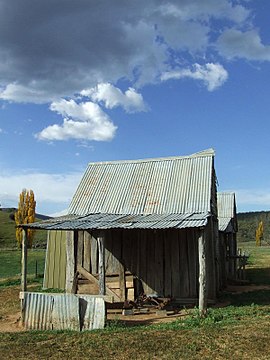
Googong Foreshores is a heritage-listed historic precinct at London Bridge Road, Burra, New South Wales, Australia. It consists of the historic surroundings of the Googong Dam that predated the dam itself. It is also known as the Googong Foreshores Cultural and Geodiversity Heritage Areas. It was added to the Australian Commonwealth Heritage List on 3 November 2017.
Bumbalong is a rural locality in the Snowy Monaro Region, New South Wales, Australia. Although it lies in the valley of the Murrumbidgee River, it is sometimes referred to by its residents as Bumbalong Valley. At the 2016 census, it had a population of 24.