
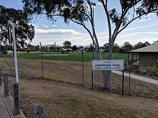
Sutton is a small village in the Southern Tablelands of New South Wales, Australia in Yass Valley Shire. It is situated on the west bank of the Yass River, about 17 kilometres south of Gundaroo, near the Federal Highway, not far from Canberra. It has a primary school, an Anglican church, a general store, an estate agent, an artists gallery, and a baker. Sutton has its own volunteer Bush Fire Brigade located in the village.

Boro is a rural locality of New South Wales, Australia in the Queanbeyan-Palerang Region, near the village of Tarago, about 50 km south of Goulburn. The name is a variation of the Aboriginal bora ring. At the 2021 census, it had a population of 97.
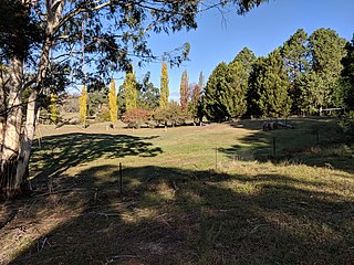
Crestwood is a suburb of Queanbeyan, New South Wales, Australia. Crestwood is located west of the central business district (CBD) to the west of Ross Road and the north of Canberra Avenue and also borders the Australian Capital Territory. At the 2021 census, it had a population of 4,936.

Hoskinstown is a locality in Queanbeyan-Palerang Regional Council, New South Wales, Australia. The locality, and what remains of the cluster of settlement of the same name, is 38 km southeast of Canberra the Capital city of Australia, and 299 km southwest of Sydney. At the 2021 census, it had a population of 191.

Bywong is a rural residential area in the Southern Tablelands of New South Wales, Australia in the Queanbeyan-Palerang Regional Council LGA. It is approximately 24 kilometres north-east of the Australian city of Canberra on the Federal Highway. It is also traversed by Macs Reef Road, Shingle Hill Way and Bungendore Road, the last two roads connecting Gundaroo and Bungendore. Its name is derived from an aboriginal word for "big hill". At the 2021 census, it had a population of 1,342. It had a public school from 1895 to 1906. It has a community association called Bywong Community Inc. Its local Pony Club is called Gearys Gap Pony Club, which meets at the Les Reardon Reserve, Bywong.

Rossi is a locality in the Queanbeyan–Palerang Regional Council, New South Wales, Australia. It is located about 33 km southeast of Queanbeyan and 25 km north of Captains Flat. At the 2016 census, it had a population of 95.

Wollogorang is a locality in the Upper Lachlan Shire and Goulburn Mulwaree Council, New South Wales, Australia. A small part of the locality is in Queanbeyan–Palerang Regional Council. It is located about 35 km southwest of Goulburn and 61 km northeast of Canberra. It lies on both sides of the Federal Highway and on the southern side of the Hume Highway. They intersect nearby to the northeast in the locality of Yarra. At the 2016 census, it had a population of 67.
Primrose Valley is a locality in the Queanbeyan–Palerang Regional Council area, New South Wales, Australia. It is located on the road from Queanbeyan to Captains Flat about 33 km southeast of Queanbeyan and 25 km north of Captains Flat. At the 2016 census, it had a population of 146. It had a provisional school from 1884 to 1886 and a half-time school from 1887 to 1889.

Forbes Creek is a locality in Queanbeyan-Palerang Regional Council, New South Wales, Australia. The town lies 45 km east of Canberra. At the 2021 census, it had a population of 62. The Tallaganda National Park includes part of its eastern edge.
Harolds Cross is a locality in the Queanbeyan–Palerang Regional Council, New South Wales, Australia. It is located about 11 km northeast of Captains Flat and 35 km southwest of Braidwood. At the 2021 census, it had a population of 79. It had a "half-time" school from 1868 and 1915; from 1949 to 1957, it operated as a "provisional school".

Ballalaba is a locality in the Queanbeyan–Palerang Regional Council, New South Wales, Australia. It is located about 30 km southwest of Braidwood on the road to Cooma and on the Shoalhaven River. At the 2021 census, it had a population of 29. It had a "half-time" school from 1867 to 1870; from 1879 to 1940, it operated either as a "provisional" or a "half-time" school".

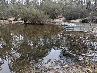
Bendoura is a locality in the Queanbeyan–Palerang Regional Council, New South Wales, Australia. It is located about 20 km southwest of Braidwood on the road to Cooma and on the eastern bank of the Shoalhaven River. At the 2021 census, it had a population of 108.

Bombay is a locality in the Queanbeyan–Palerang Regional Council, New South Wales, Australia. It is located about 14 km southwest of Braidwood on the western bank of the Shoalhaven River. At the 2021 census, it had a population of 142. It has two areas of somewhat denser settlement described as "Bombay" and "Little Bombay". It had a school in 1871 and from 1873 to 1928, normally described as "Bombay Half-Time School" but sometimes as "Bombay Provisional School".
Berlang is a locality in Queanbeyan-Palerang Regional Council, New South Wales, Australia. It was previously called Tallaganda. The town lies about 44 km south of Braidwood on the upper Shoalhaven River and the road to Cooma. At the 2021 census, it had a population of none. It includes part of the Deua National Park and the Berlang State Conservation Area. The Big Hole is a notable geological feature in the locality and the Deua National Park.

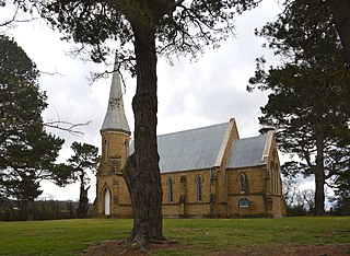
Mayfield is a locality in the Queanbeyan–Palerang Regional Council, New South Wales, Australia. It is located about 85 km east of Canberra and 58 km south of Goulburn. At the 2021 census, it had a population of 57. It had an Anglican church, St Luke's from 1895 to 1965. A "half-time" school was located at Virginia station in Mayfield from 1894 to 1899.

Northangera is a locality in the Queanbeyan-Palerang Region, Southern Tablelands, New South Wales, Australia. The name Northangera was assigned on 13 July 2001. It lies on the Kings Highway about 100 km east of Canberra and 15 km east of Braidwood. At the 2016 census, it had a population of 43.
Tomboye is a locality in the Queanbeyan–Palerang Regional Council, New South Wales, Australia. It is located on the north side of the Mongarlowe River on the road from Braidwood to Nowra about 28 km north of Braidwood and 93 km southwest of Nowra. At the 2016 census, it had a population of 40. It consists mainly of forest and grazing country.

Wog Wog is a locality in the Queanbeyan–Palerang Regional Council, New South Wales, Australia. It is located on the south side of the Corang River and to the east of the road from Braidwood to Nowra about 34 km north of Braidwood and 96 km southwest of Nowra. At the 2021 census, it had a population of 15. It consists mainly of forest, including parts of the Morton National Park. Its eastern boundary runs along the Budawang Range and includes Wog Wog Mountain and Corang Peak.

Corang is a locality in the Queanbeyan–Palerang Regional Council, New South Wales, Australia. It is located on the north side of the Corang River and to the east of the road from Braidwood to Nowra about 46 km north of Braidwood and 75 km southwest of Nowra. At the 2016 census, it had a population of 13. It consists mainly of forest and most of it lies in the Morton National Park. Its eastern boundary runs along the Budawang Range and includes Mount Tarn, Sturgiss Mountain and Quiltys Mountain.

Reidsdale is a locality in the Queanbeyan–Palerang Regional Council, New South Wales, Australia. It is located about 17 km southeast of Braidwood. At the 2016 census, it had a population of 125. It had a school from 1883 to 1923 and from 1943 to 1946, operating as a "public school" until 1922 and then as a "provisional" school".

