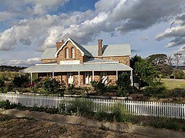
Goulburn is a regional city in the Southern Tablelands of the Australian state of New South Wales, approximately 195 kilometres (121 mi) south-west of Sydney, and 90 kilometres (56 mi) north-east of Canberra. It was proclaimed as Australia's first inland city through letters patent by Queen Victoria in 1863. Goulburn had a population of 23,835 at June 2018. Goulburn is the seat of Goulburn Mulwaree Council.

Tallong is a village within the Southern Tablelands region of New South Wales, Australia, in Goulburn-Mulwaree Council. The village is located just outside the southern extremity of the Southern Highlands region and has some cultural and historic connections with this region also. In the 2016 census, the village had a population of 813. The town is 8.5 km from the town of Marulan and 25 km from the town of Bundanoon.
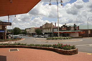
Crookwell is a small town located in the Southern Tablelands of New South Wales, Australia, in the Upper Lachlan Shire. At the 2016 census, Crookwell had a population of 2,641. The town is at a relatively high altitude of 887 metres and there are several snowfalls annually, especially during the winter months. The nearest major centre is the city of Goulburn which is about a half-hour drive to the south-east of the town. Crookwell is easily accessible to the state capital of Sydney and also the federal capital of Canberra.

Nerriga is a small village in the Southern Tablelands of New South Wales, Australia in Queanbeyan-Palerang Regional Council. It is situated at the edge of Morton National Park, on the Braidwood - Nowra road. The population of Nerriga and the surrounding localities at the 2016 census was 72.

Bungonia is a small town in the Southern Tablelands in New South Wales, Australia in Goulburn Mulwaree. At the 2016 census, Bungonia had a population of 367. The name of the town derives from an Aboriginal word meaning 'sandy creek'.

Goulburn Mulwaree Council is a local government area located in the Southern Tablelands region of New South Wales, Australia. The area is located adjacent to the Hume Highway and the Southern Highlands railway line. The estimated resident population of the area stood at 29,609 on 2016 census.

Currawang is a locality in the Queanbeyan–Palerang Regional Council, on the edges of Upper Lachlan Shire and Goulburn-Mulwaree Council, in New South Wales, Australia. It is located to the north of Lake George. It shares its name with the Currawang Parish of Argyle County, in which it is located. This was formerly known as the parish of Currowang. Both names derive from an Aboriginal word for the spearwood tree.

Windellama is a rural locality in the Southern Tablelands of New South Wales, Australia in the Goulburn Mulwaree Council. It is northeast of Canberra and southeast of Goulburn. At the 2016 census, it had a population of 357.
Yarra is a locality in the Goulburn Mulwaree Council, New South Wales, Australia. It is located about 18 km southwest of Goulburn, 84 km northeast of Canberra and 213 km southwest of Sydney. It lies at the intersection of the Federal Highway and the Hume Highway. At the 2016 census, it had a population of 173. Yarra railway station was a station on the Main Southern railway line from 1875 to the 1970s. A small settlement grew up around the railway station and the Hume Highway, parts of which were demolished during road widening in the 1970s. It had a public school from 1869 to 1970, operating as a "half-time" school until 1873.

Chatsbury is a locality in the Upper Lachlan Shire, New South Wales, Australia. It lies about 22 km north of Goulburn and 22 km south of Taralga on the road from Goulburn to Oberon and Bathurst. At the 2016 census, it had a population of 91.

Colinton is a locality in the Snowy Monaro Region, New South Wales, Australia. At the 2016 census, it had a population of 127. There was once a village and railway station of the same name.

Mayfield is a locality in the Queanbeyan–Palerang Regional Council, New South Wales, Australia. It is located about 85 km east of Canberra and 58 km south of Goulburn. At the 2016 census, it had a population of 22. It had an Anglican church, St Luke's from 1895 to 1965. A "half-time" school was located at Virginia station in Mayfield from 1894 to 1899.

Richlands is a locality in the Upper Lachlan Shire, New South Wales, Australia. It lies about 5 km north of Taralga and about 95 km south of Oberon on the road from Goulburn to Oberon and Bathurst. At the 2016 census, it had a population of 34. It had a school from June 1868 to August 1879, which was designated as a "provisional school" for eight months and then as a "half-time" school. It also had a school from 1884 to 1915 and from 1918 to 1953, classified most commonly as a "provisional school", but for periods as a "house to house", "half-time" or "public" school. It was called Abercrombie school until 1894.

Curraweela is a locality in the Upper Lachlan Shire, New South Wales, Australia. It lies about 20 km (12 mi) north of Taralga and about 80 km (50 mi) south Oberon on the road from Goulburn to Oberon and Bathurst. At the 2016 census, it had a population of 47. It had a school from 1878 to 1900, which was variously designated as a "half-time", "provisional" and "house to house" school.

Woodhouselee is a locality in the Upper Lachlan Shire, New South Wales, Australia. It lies about 25 km northwest of Goulburn and 115 km northeast of Canberra. At the 2016 census, it had a population of 15.
Wayo is a locality mainly in the Upper Lachlan Shire, New South Wales, Australia. Part of it is in Goulburn Mulwaree Council. It lies about 20 km northwest of Goulburn and 110 km northeast of Canberra. At the 2016 census, it had a population of 119.

Yerriyong is a locality in the City of Shoalhaven in New South Wales, Australia. It lies about 17 km to the southwest of Nowra on the road to Nerriga and Canberra. It is largely made up of eucalyptus forest. At the 2016 census, it had a population of 25.

Baw Baw is a locality in the Goulburn Mulwaree Council, New South Wales, Australia. It lies about 7 km north of Goulburn and 95 km northeast of Canberra. At the 2016 census, it had a population of 260.

Mummel is a locality in the Goulburn Mulwaree Council, New South Wales, Australia. It lies about 23 km northwest of Goulburn and 110 km northeast of Canberra. At the 2016 census, it had a population of 112.

Parkesbourne is a locality in the Goulburn Mulwaree Council, New South Wales, Australia. The Hume Highway runs on its southern edge. It lies about 20 km west of Goulburn and 90 km northeast of Canberra. At the 2016 census, it had a population of 170.