Argyle County

Last updated

Map all coordinates using: OpenStreetMap  
Download coordinates as: KML
Argyle
New South Wales
Argyle NSW.PNG
Location of Argyle
Australia New South Wales location map blank.svg
Red pog.svg
Argyle
Coordinates 34°49′24″S149°44′04″E / 34.82333°S 149.73444°E / -34.82333; 149.73444 (Argyle County) Coordinates: 34°49′24″S149°44′04″E / 34.82333°S 149.73444°E / -34.82333; 149.73444 (Argyle County)
Lands administrative divisions around Argyle:
Georgiana Westmoreland Camden
King Argyle St Vincent
Murray Murray St Vincent
1840s map of the County of Argyle County of Argyle NSW 1840s.jpg
1840s map of the County of Argyle

Argyle County was one of the original Nineteen Counties in New South Wales and is now one of the 141 Cadastral divisions of New South Wales. It includes the area around Goulburn. It is bounded by Lake George in the south-west, the Shoalhaven River in the east, and the Wollondilly River in the north-east.

Contents

Argyle County was named by Governor Macquarie after his native county in Scotland. [1] He named it while inspecting the area in 1820. [2]

In 1829 the Act for Instituting and regulating Courts of General and Quarter Sessions in New South Wales established courts in the county at Cookbundoon, Goulburn Plains and Inverary. [3] James Byrne was Assistant Surveyor for the County in 1832. [4] In 1835 Argyle had a magistrate and police force. [5]

In 1852 it had an area of 1,248,600 acres (5,053 km2) and population of 5,565. [6] It was also described as having productive land and inexhaustible water.

In 1857, Charles Cowper was a major landowner in the area, and held 19,720 acres (79.8 km2) in the county. [7] The Electoral district of Argyle was the former state electoral district for the area between 1856 and 1904. The Encyclopædia Britannica Eleventh Edition mentions Goulburn as being in the county. [8]

The Greater Argyle Council was formed in 2004 after a proposal [9] to make a new local government area to focus on the County of Argyle, formed from an amalgamation of the former City of Goulburn and parts of Mulwaree Shire. It was renamed the Goulburn Mulwaree Council in October 2004. [10]

Parishes within this county

A full list of parishes found within this county; their current LGA and mapping coordinates to the approximate centre of each location is as follows:

ParishLGACoordinates
Bannaby Upper Lachlan ( 34°23′54″S149°59′04″E / 34.39833°S 149.98444°E / -34.39833; 149.98444 (Bannaby Parish) )
Baw Baw Goulburn Mulwaree Council ( 34°42′54″S149°38′04″E / 34.71500°S 149.63444°E / -34.71500; 149.63444 (Baw Baw Parish) )
Billyrambija Goulburn Mulwaree Council ( 34°40′54″S149°56′04″E / 34.68167°S 149.93444°E / -34.68167; 149.93444 (Billyrambija Parish) )
Boro Goulburn Mulwaree Council ( 35°07′54″S149°45′04″E / 35.13167°S 149.75111°E / -35.13167; 149.75111 (Boro Parish) )
Bourke Upper Lachlan ( 34°21′54″S150°02′04″E / 34.36500°S 150.03444°E / -34.36500; 150.03444 (Bourke Parish) )
Breadalbane Goulburn Mulwaree Council ( 34°47′04″S149°30′03″E / 34.78444°S 149.50083°E / -34.78444; 149.50083 (Breadalbane Parish) )
Bungonia Goulburn Mulwaree Council ( 34°52′54″S149°55′04″E / 34.88167°S 149.91778°E / -34.88167; 149.91778 (Bungonia Parish) )
Collector Upper Lachlan ( 34°54′54″S149°25′04″E / 34.91500°S 149.41778°E / -34.91500; 149.41778 (Collector Parish) )
Cookbundoon Upper Lachlan ( 34°33′54″S149°56′04″E / 34.56500°S 149.93444°E / -34.56500; 149.93444 (Cookbundoon Parish) )
Covan Goulburn Mulwaree Council ( 34°59′54″S149°37′04″E / 34.99833°S 149.61778°E / -34.99833; 149.61778 (Covan Parish) )
Cullulla Goulburn Mulwaree Council ( 35°03′54″S149°51′04″E / 35.06500°S 149.85111°E / -35.06500; 149.85111 (Cullulla Parish) )
Currawang Palerang ( 34°59′54″S149°30′04″E / 34.99833°S 149.50111°E / -34.99833; 149.50111 (Currawang Parish) )
Eden Forest Upper Lachlan ( 34°33′54″S150°00′04″E / 34.56500°S 150.00111°E / -34.56500; 150.00111 (Eden Forest Parish) )
Goulburn Goulburn Mulwaree Council ( 34°45′54″S149°42′04″E / 34.76500°S 149.70111°E / -34.76500; 149.70111 (Goulburn Parish) )
Guineacor Upper Lachlan ( 34°23′20″S149°47′19″E / 34.38889°S 149.78861°E / -34.38889; 149.78861 (Guineacor Parish) )
Gundary Goulburn Mulwaree Council ( 34°50′54″S149°46′04″E / 34.84833°S 149.76778°E / -34.84833; 149.76778 (Gundary Parish) )
Gurrundah Upper Lachlan ( 34°41′54″S149°30′04″E / 34.69833°S 149.50111°E / -34.69833; 149.50111 (Gurrundah Parish) )
Inverary Goulburn Mulwaree Council ( 34°54′54″S150°02′04″E / 34.91500°S 150.03444°E / -34.91500; 150.03444 (Inverary Parish) )
Jerralong Goulburn Mulwaree Council ( 35°06′54″S149°58′04″E / 35.11500°S 149.96778°E / -35.11500; 149.96778 (Jerralong Parish) )
Jerrara Goulburn Mulwaree Council ( 34°47′54″S150°00′04″E / 34.79833°S 150.00111°E / -34.79833; 150.00111 (Jerrara Parish) )
Kerrawary Upper Lachlan ( 34°27′54″S150°00′04″E / 34.46500°S 150.00111°E / -34.46500; 150.00111 (Kerrawary Parish) )
Mangamore Goulburn Mulwaree Council ( 34°54′54″S149°40′04″E / 34.91500°S 149.66778°E / -34.91500; 149.66778 (Mangamore Parish) )
Marulan Goulburn Mulwaree Council ( 34°44′54″S150°00′04″E / 34.74833°S 150.00111°E / -34.74833; 150.00111 (Marulan Parish) )
Milbang Upper Lachlan ( 34°49′54″S149°26′04″E / 34.83167°S 149.43444°E / -34.83167; 149.43444 (Milbang Parish) )
Mullengullenga Goulburn Mulwaree Council ( 35°00′54″S149°45′04″E / 35.01500°S 149.75111°E / -35.01500; 149.75111 (Mullengullenga Parish) )
Mulwaree Goulburn Mulwaree Council ( 35°05′54″S149°40′04″E / 35.09833°S 149.66778°E / -35.09833; 149.66778 (Mulwaree Parish) )
Mummel Goulburn Mulwaree Council ( 34°40′54″S149°33′04″E / 34.68167°S 149.55111°E / -34.68167; 149.55111 (Mummel Parish) )
Mutmutbilly Upper Lachlan ( 34°45′54″S149°28′04″E / 34.76500°S 149.46778°E / -34.76500; 149.46778 (Mutmutbilly Parish) )
Nadgigomar Goulburn Mulwaree Council ( 35°08′54″S149°47′04″E / 35.14833°S 149.78444°E / -35.14833; 149.78444 (Nadgigomar Parish) )
Narrangarril Goulburn Mulwaree Council ( 34°41′54″S149°44′04″E / 34.69833°S 149.73444°E / -34.69833; 149.73444 (Narrangarril Parish) )
Nattery Goulburn Mulwaree Council ( 34°44′54″S149°52′04″E / 34.74833°S 149.86778°E / -34.74833; 149.86778 (Nattery Parish) )
Nerrimunga Goulburn Mulwaree Council ( 34°58′54″S150°03′04″E / 34.98167°S 150.05111°E / -34.98167; 150.05111 (Nerrimunga Parish) )
Norrong Goulburn Mulwaree Council ( 34°39′54″S149°52′04″E / 34.66500°S 149.86778°E / -34.66500; 149.86778 (Norrong Parish) )
Oallen Goulburn Mulwaree Council ( 35°10′54″S149°53′04″E / 35.18167°S 149.88444°E / -35.18167; 149.88444 (Oallen Parish) )
Pejar Upper Lachlan ( 34°30′54″S149°32′04″E / 34.51500°S 149.53444°E / -34.51500; 149.53444 (Pejar Parish) )
Pomeroy Upper Lachlan ( 34°36′54″S149°30′04″E / 34.61500°S 149.50111°E / -34.61500; 149.50111 (Pomeroy Parish) )
Quialigo Goulburn Mulwaree Council ( 34°56′54″S149°46′04″E / 34.94833°S 149.76778°E / -34.94833; 149.76778 (Quialigo Parish) )
Rhyana Goulburn Mulwaree Council ( 34°35′54″S149°44′04″E / 34.59833°S 149.73444°E / -34.59833; 149.73444 (Rhyana Parish) )
Strathaird Upper Lachlan ( 34°27′54″S149°53′04″E / 34.46500°S 149.88444°E / -34.46500; 149.88444 (Strathaird Parish) )
Tarago Goulburn Mulwaree Council ( 34°52′54″S149°33′04″E / 34.88167°S 149.55111°E / -34.88167; 149.55111 (Tarago Parish) )
Tarlo Upper Lachlan ( 34°34′54″S149°48′04″E / 34.58167°S 149.80111°E / -34.58167; 149.80111 (Tarlo Parish) )
Terranna Goulburn Mulwaree Council ( 34°51′54″S149°40′04″E / 34.86500°S 149.66778°E / -34.86500; 149.66778 (Terranna Parish) )
Towrang Goulburn Mulwaree Council ( 34°44′54″S149°45′04″E / 34.74833°S 149.75111°E / -34.74833; 149.75111 (Towrang Parish) )
Turrallo Upper Lachlan ( 34°30′54″S149°46′04″E / 34.51500°S 149.76778°E / -34.51500; 149.76778 (Turrallo Parish) )
Upper Tarlo Upper Lachlan ( 34°30′54″S149°38′04″E / 34.51500°S 149.63444°E / -34.51500; 149.63444 (Upper Tarlo Parish) )
Uringalla Goulburn Mulwaree Council ( 34°38′54″S150°02′04″E / 34.64833°S 150.03444°E / -34.64833; 150.03444 (Uringalla Parish) )
Wayo Upper Lachlan ( 34°35′54″S149°38′04″E / 34.59833°S 149.63444°E / -34.59833; 149.63444 (Wayo Parish) )
Willeroo Goulburn Mulwaree Council ( 34°59′54″S149°33′04″E / 34.99833°S 149.55111°E / -34.99833; 149.55111 (Willeroo Parish) )
Wologorong Goulburn Mulwaree Council ( 34°49′54″S149°33′04″E / 34.83167°S 149.55111°E / -34.83167; 149.55111 (Wologorong Parish) )
Yarralaw Goulburn Mulwaree Council ( 34°59′54″S149°52′04″E / 34.99833°S 149.86778°E / -34.99833; 149.86778 (Yarralaw Parish) )

Related Research Articles

<span class="mw-page-title-main">Goulburn</span> City in New South Wales, Australia

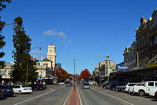
Goulburn is a regional city in the Southern Tablelands of the Australian state of New South Wales, approximately 195 kilometres (121 mi) south-west of Sydney, and 90 kilometres (56 mi) north-east of Canberra. It was proclaimed as Australia's first inland city through letters patent by Queen Victoria in 1863. Goulburn had a population of 23,835 at June 2018. Goulburn is the seat of Goulburn Mulwaree Council.

<span class="mw-page-title-main">Tallong, New South Wales</span> Town in New South Wales, Australia

Tallong is in the traditional lands of the Gundungurra people. It is a village within the Southern Tablelands region of New South Wales, Australia, in Goulburn-Mulwaree Council. The village is located just outside the southern extremity of the Southern Highlands region and has some cultural and historic connections with this region also. In the 2016 census, the village had a population of 813. The town is 8.5 km from the town of Marulan and 25 km from the town of Bundanoon.

<span class="mw-page-title-main">Division of Hume</span> Australian federal electoral division

The Division of Hume is an Australian electoral division in the state of New South Wales.

<span class="mw-page-title-main">Pejar Dam</span> Dam in Southern Tablelands, New South Wales

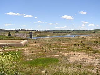
The Pejar Dam is an earth and rock-filled embankment dam with an uncontrolled spillway across the Wollondilly River, located in the Southern Tablelands region of New South Wales, Australia. The principal purpose of the dam is to supply potable water for the city of Goulburn. The impounded 9,000-megalitre reservoir is also called Pejar Dam.

<span class="mw-page-title-main">Palerang Council</span> Former local government area in New South Wales, Australia

The Palerang Council was a local government area located in the Southern Tablelands region of New South Wales, Australia. On 12 May 2016 the Minister for Local Government announced dissolution of the Palerang Council with immediate effect. Together with Queanbeyan City the combined council areas were merged to establish the Queanbeyan-Palerang Regional Council. Both councils had opposed the amalgamation. Elections for the new Council area were held in September 2017. The former mayor of Queanbeyan City Council was appointed by the New South Wales Government as administrator until that date.

<span class="mw-page-title-main">Gundaroo</span> Town in New South Wales, Australia

Gundaroo is a small village in the Southern Tablelands of New South Wales, Australia and in Yass Valley Council. It is situated to the east of the Yass River, about 16 kilometres (10 mi) north of Sutton, about 15 kilometres (9 mi) west of the Lake George range. At the 2016 census, Gundaroo "state suburb" had a population of 1,146. At the 2006 census, its "urban centre/locality" had a population of 331.

<span class="mw-page-title-main">Electoral district of Goulburn</span>

Goulburn is an electoral district of the Legislative Assembly in the Australian state of New South Wales. It is represented by Wendy Tuckerman of the Liberal Party.

<span class="mw-page-title-main">Lands administrative divisions of New South Wales</span>

For lands administrative purposes, New South Wales is divided into 141 counties, which are further divided into parishes. The counties were first set down in the Colony of New South Wales, which later became the Australian state of New South Wales.

<span class="mw-page-title-main">Northumberland County, New South Wales</span> Cadastral in New South Wales, Australia

Northumberland County was one of the original Nineteen Counties in New South Wales and is now one of the 141 Cadastral divisions of New South Wales. It included the area to the north of Broken Bay, which compasses the Central Coast region and Lake Macquarie as well as Newcastle(Greater Newcastle) in the Hunter region. It was bounded by the part of the Hawkesbury River to the south, the Macdonald River to the south-west, and the Hunter River to the north.

<span class="mw-page-title-main">Bungonia, New South Wales</span> Suburb of Goulburn Mulwaree Council, New South Wales, Australia

Bungonia is a small town in the Southern Tablelands in New South Wales, Australia in Goulburn Mulwaree. At the 2016 census, Bungonia had a population of 367. The name of the town derives from an Aboriginal word meaning 'sandy creek'.

<span class="mw-page-title-main">Parish of Marulan</span> Cadastral in New South Wales, Australia

The Parish of Marulan is a parish of Argyle County located with the Goulburn Mulwaree local government area, which includes the towns of Marulan and Marulan South. The parish is bounded by Barbers Creek to the east, a small part of the Shoalhaven River to the south-east, and Jerrara Creek to the south. The Hume Highway and the Southern Highlands railway line run through the parish. Jerrara Road and Marulan South Road are other main roads in the area.

<span class="mw-page-title-main">Parish of Tarago</span> Cadastral in New South Wales, Australia

The Parish of Tarago is a parish of Argyle County. It does not actually contain the town of Tarago, which is located further to the south-east in the Parish of Mulwaree. The Parish was built by the Department of Lands in New South Wales.

The Parish of Wologorong is a parish of Argyle County, New South Wales, Australia.

The Parish of Goulburn is a parish of Argyle County which includes most of the city of Goulburn, New South Wales.

<span class="mw-page-title-main">Goulburn Mulwaree Council</span> Local government area in New South Wales, Australia

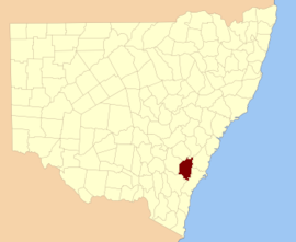
Goulburn Mulwaree Council is a local government area located in the Southern Tablelands region of New South Wales, Australia. The area is located adjacent to the Hume Highway and the Southern Highlands railway line. The estimated resident population of the area stood at 32,053 on 2021 census.

<span class="mw-page-title-main">Electoral district of County of Argyle</span> Former New South Wales Legislative Council electoral district

The Electoral district of County of Argyle was an electorate of the New South Wales Legislative Council at a time when some of its members were elected and the balance were appointed by the Governor.

<span class="mw-page-title-main">Currawang</span> Cadastral in New South Wales, Australia

Currawang is a locality in the Queanbeyan–Palerang Regional Council, on the edges of Upper Lachlan Shire and Goulburn-Mulwaree Council, in New South Wales, Australia. It is located to the north of Lake George. It shares its name with the Currawang Parish of Argyle County, in which it is located. This was formerly known as the parish of Currowang. Both names derive from an Aboriginal word for the spearwood tree.

<span class="mw-page-title-main">Parish of Baw Baw</span> Cadastral in New South Wales, Australia

The Parish of Baw Baw is a parish of Argyle County, New South Wales, Australia. It is located in to the west of Goulburn, in Goulburn Mulwaree Council at 34°42′54″S, 149°38′04″E.

<span class="mw-page-title-main">Parish of Terranna</span> Cadastral in New South Wales, Australia

The Parish of Terrana is a parish of Argyle County, New South Wales, Australia.

Sydney City, an electoral district of the Legislative Assembly in the Australian state of New South Wales, had two incarnations, from 1950 until 1971 and from 1988 until 1999.

References

  1. "Argyle". Geographical Names Register (GNR) of NSW. Geographical Names Board of New South Wales. OOjs UI icon edit-ltr-progressive.svg
  2. Richlands Homestead via Taralga, NSW Archived 2007-09-28 at the Wayback Machine
  3. Archives investigator, Courts of General and Quarter Sessions Archived September 3, 2007, at the Wayback Machine
  4. Greenwich Meadows-Farms for sale Archived August 28, 2007, at the Wayback Machine
  5. Police NSW, history docs, Argyle Police Force Archived August 30, 2007, at the Wayback Machine
  6. "Old Welsh Books with English Translations", The Land of Gold: the Companion for the Welsh Emigrant to Australia, 1852
  7. "Sir Charles Cowper (1807-1875)". Former members of the Parliament of New South Wales . Retrieved 11 May 2019.
  8. Chisholm, Hugh, ed. (1911). "Goulburn"  . Encyclopædia Britannica . Vol. 12 (11th ed.). Cambridge University Press. p. 284.
  9. Proposal Greater Argyle City Council Archived September 26, 2007, at the Wayback Machine
  10. Goulburn Mulwaree Council meeting, Nov. 2004 Renaming of Argyle to Goulburn Mulwaree Archived August 29, 2007, at the Wayback Machine