Urana County

Last updated

Map all coordinates using: OpenStreetMap  
Download coordinates as: KML  ·  GPX
Urana
New South Wales
Urana NSW.PNG
Location in New South Wales
Lands administrative divisions around Urana:
Boyd Boyd Mitchell
Townsend Urana Mitchell
Townsend Denison Hume

Urana County is one of the 141 Cadastral divisions of New South Wales. It contains the towns of Urana and Bidgeemia.

The name Urana is believed to be derived from a local Aboriginal word, [1] and is referenced in relation to the town of Urana, New South Wales as coming from the Aboriginal word 'airana', meaning a temporary shelter (usually consisting of a simple frame of branches covered with bark, leaves, or grass). [2]

Parishes within this county

A full list of parishes found within this county; their current LGA and mapping coordinates to the approximate centre of each location is as follows:

Urana County NSW as shown on John Sands 1886 map) Urana County NSW (John Sands 1886 map).png
Urana County NSW as shown on John Sands 1886 map)
ParishLGACoordinates
Betts Federation Council 35°04′54″S146°13′04″E / 35.08167°S 146.21778°E / -35.08167; 146.21778 (Betts)
Bingagong Federation Council 34°58′54″S146°17′04″E / 34.98167°S 146.28444°E / -34.98167; 146.28444 (Bingagong)
Bolton Murrumbidgee Council 35°12′54″S145°49′04″E / 35.21500°S 145.81778°E / -35.21500; 145.81778 (Bolton)
Booroobanilly Murrumbidgee Council 35°28′54″S145°34′04″E / 35.48167°S 145.56778°E / -35.48167; 145.56778 (Booroobanilly)
Boree Creek Federation Council 35°04′54″S146°39′04″E / 35.08167°S 146.65111°E / -35.08167; 146.65111 (Boree Creek)
Boreegerry Federation Council 35°32′54″S146°05′04″E / 35.54833°S 146.08444°E / -35.54833; 146.08444 (Boreegerry)
Brookong North Lockhart Shire 35°10′54″S146°00′04″E / 35.18167°S 146.00111°E / -35.18167; 146.00111 (Brookong North)
Brookong Lockhart Shire 35°17′54″S146°35′04″E / 35.29833°S 146.58444°E / -35.29833; 146.58444 (Brookong)
Broome Murrumbidgee Council 35°05′54″S145°49′04″E / 35.09833°S 145.81778°E / -35.09833; 145.81778 (Broome)
Bundure North Murrumbidgee Council 35°02′54″S145°59′04″E / 35.04833°S 145.98444°E / -35.04833; 145.98444 (Bundure North)
Bundure Murrumbidgee Council 35°05′54″S145°59′04″E / 35.09833°S 145.98444°E / -35.09833; 145.98444 (Bundure)
Butherwa Federation Council 35°15′54″S146°21′04″E / 35.26500°S 146.35111°E / -35.26500; 146.35111 (Butherwa)
Cadell Murrumbidgee Council 35°01′54″S145°52′04″E / 35.03167°S 145.86778°E / -35.03167; 145.86778 (Cadell)
Carnerney Murrumbidgee Council 35°16′15″S145°50′08″E / 35.27083°S 145.83556°E / -35.27083; 145.83556 (Carnerney)
Clear Hill Federation Council 35°28′54″S146°11′04″E / 35.48167°S 146.18444°E / -35.48167; 146.18444 (Clear Hill)
Clear Hill Federation Council 35°30′54″S146°10′04″E / 35.51500°S 146.16778°E / -35.51500; 146.16778 (Clear Hill)
Clive Lockhart Shire 35°23′54″S146°45′04″E / 35.39833°S 146.75111°E / -35.39833; 146.75111 (Clive)
Clyde Narrandera Shire 35°01′54″S146°27′04″E / 35.03167°S 146.45111°E / -35.03167; 146.45111 (Clyde)
Cocketgedong Federation Council 35°14′54″S145°59′04″E / 35.24833°S 145.98444°E / -35.24833; 145.98444 (Cocketgedong)
Colkmannan Federation Council 34°57′54″S146°08′04″E / 34.96500°S 146.13444°E / -34.96500; 146.13444 (Colkmannan)
Colombo Federation Council 35°07′54″S146°06′04″E / 35.13167°S 146.10111°E / -35.13167; 146.10111 (Colombo)
Combermere Federation Council 35°23′54″S146°05′04″E / 35.39833°S 146.08444°E / -35.39833; 146.08444 (Combermere)
Coonong Federation Council 35°11′54″S146°10′04″E / 35.19833°S 146.16778°E / -35.19833; 146.16778 (Coonong)
Coree North Murrumbidgee Council 35°17′54″S145°35′04″E / 35.29833°S 145.58444°E / -35.29833; 145.58444 (Coree North)
Coree South Murrumbidgee Council 35°23′54″S145°34′04″E / 35.39833°S 145.56778°E / -35.39833; 145.56778 (Coree South)
Crommelin Federation Council 35°00′54″S146°07′04″E / 35.01500°S 146.11778°E / -35.01500; 146.11778 (Crommelin)
Cullivel Lockhart Shire 35°16′54″S146°30′04″E / 35.28167°S 146.50111°E / -35.28167; 146.50111 (Cullivel)
Douglas Federation Council 35°04′54″S146°04′04″E / 35.08167°S 146.06778°E / -35.08167; 146.06778 (Douglas)
Faed Federation Council 35°22′54″S146°22′04″E / 35.38167°S 146.36778°E / -35.38167; 146.36778 (Faed)
Finlay Lockhart Shire 35°25′54″S146°35′04″E / 35.43167°S 146.58444°E / -35.43167; 146.58444 (Finlay)
Galore Lockhart Shire 35°10′54″S146°45′04″E / 35.18167°S 146.75111°E / -35.18167; 146.75111 (Galore)
Goolgumbla Murrumbidgee Council 35°03′54″S145°37′04″E / 35.06500°S 145.61778°E / -35.06500; 145.61778 (Goolgumbla)
Gunambill Federation Council 35°15′54″S146°15′04″E / 35.26500°S 146.25111°E / -35.26500; 146.25111 (Gunambill)
Gunambill Federation Council 35°33′54″S146°15′04″E / 35.56500°S 146.25111°E / -35.56500; 146.25111 (Gunambill)
Hardie Murrumbidgee Council 35°28′54″S145°54′04″E / 35.48167°S 145.90111°E / -35.48167; 145.90111 (Hardie)
Hastings Federation Council 35°23′54″S146°10′04″E / 35.39833°S 146.16778°E / -35.39833; 146.16778 (Hastings)
Hebden Lockhart Shire 35°17′54″S146°40′04″E / 35.29833°S 146.66778°E / -35.29833; 146.66778 (Hebden)
Henty Federation Council 35°28′54″S146°05′04″E / 35.48167°S 146.08444°E / -35.48167; 146.08444 (Henty)
Howell Federation Council 34°55′54″S146°14′04″E / 34.93167°S 146.23444°E / -34.93167; 146.23444 (Howell)
Jerilderie North Murrumbidgee Council 35°17′54″S145°44′04″E / 35.29833°S 145.73444°E / -35.29833; 145.73444 (Jerilderie North)
Jerilderie South Murrumbidgee Council 35°22′54″S145°44′04″E / 35.38167°S 145.73444°E / -35.38167; 145.73444 (Jerilderie South)
Kendall Federation Council 35°13′54″S146°04′04″E / 35.23167°S 146.06778°E / -35.23167; 146.06778 (Kendall)
Lake Federation Council 35°06′54″S146°31′04″E / 35.11500°S 146.51778°E / -35.11500; 146.51778 (Lake)
Lockhart Lockhart Shire 35°12′54″S146°46′04″E / 35.21500°S 146.76778°E / -35.21500; 146.76778 (Lockhart)
Mairjimmy Murrumbidgee Council 35°30′54″S145°46′04″E / 35.51500°S 145.76778°E / -35.51500; 145.76778 (Mairjimmy)
Morundah South Federation Council 35°06′54″S146°21′04″E / 35.11500°S 146.35111°E / -35.11500; 146.35111 (Morundah South)
Morundah Federation Council 35°01′18″S146°22′31″E / 35.02167°S 146.37528°E / -35.02167; 146.37528 (Morundah)
Mucra Lockhart Shire 35°11′54″S146°30′04″E / 35.19833°S 146.50111°E / -35.19833; 146.50111 (Mucra)
Munyabla Lockhart Shire 35°27′54″S146°48′04″E / 35.46500°S 146.80111°E / -35.46500; 146.80111 (Munyabla)
Napier Lockhart Shire 35°17′54″S146°46′04″E / 35.29833°S 146.76778°E / -35.29833; 146.76778 (Napier)
North Gunambill Federation Council 35°25′54″S146°16′04″E / 35.43167°S 146.26778°E / -35.43167; 146.26778 (North Gunambill)
Nowranie Murrumbidgee Council 35°21′54″S146°01′04″E / 35.36500°S 146.01778°E / -35.36500; 146.01778 (Nowranie)
Osborne Lockhart Shire 35°11′54″S146°41′04″E / 35.19833°S 146.68444°E / -35.19833; 146.68444 (Osborne)
Palmer Murrumbidgee Council 35°26′54″S146°01′04″E / 35.44833°S 146.01778°E / -35.44833; 146.01778 (Palmer)
Palmer Federation Council 35°30′54″S146°01′04″E / 35.51500°S 146.01778°E / -35.51500; 146.01778 (Palmer)
Piney Ridge Federation Council 35°10′54″S146°22′04″E / 35.18167°S 146.36778°E / -35.18167; 146.36778 (Piney Ridge)
Pullega Murrumbidgee Council 34°55′54″S145°53′04″E / 34.93167°S 145.88444°E / -34.93167; 145.88444 (Pullega)
Ross Lockhart Shire 35°27′54″S146°40′04″E / 35.46500°S 146.66778°E / -35.46500; 146.66778 (Ross)
Stanley Murrumbidgee Council 35°05′54″S145°42′04″E / 35.09833°S 145.70111°E / -35.09833; 145.70111 (Stanley)
Sumner Lockhart Shire 35°25′54″S146°31′04″E / 35.43167°S 146.51778°E / -35.43167; 146.51778 (Sumner)
Thurrowa Jerilderie 35°09′54″S145°58′04″E / 35.16500°S 145.96778°E / -35.16500; 145.96778 (Thurrowa)
Urana Federation Council 35°19′54″S146°16′04″E / 35.33167°S 146.26778°E / -35.33167; 146.26778 (Urana)
Urangeline Lockhart Shire 35°21′54″S146°31′04″E / 35.36500°S 146.51778°E / -35.36500; 146.51778 (Urangeline)
Wallandoon Lockhart Shire 35°27′54″S146°44′04″E / 35.46500°S 146.73444°E / -35.46500; 146.73444 (Wallandoon)
Waloona Murrumbidgee Council 34°54′54″S145°40′04″E / 34.91500°S 145.66778°E / -34.91500; 145.66778 (Waloona)
Watt Federation Council 35°15′54″S146°09′04″E / 35.26500°S 146.15111°E / -35.26500; 146.15111 (Watt)
Waugh Federation Council 34°58′54″S146°23′04″E / 34.98167°S 146.38444°E / -34.98167; 146.38444 (Waugh)
Widgiewa Federation Council 35°11′54″S146°16′04″E / 35.19833°S 146.26778°E / -35.19833; 146.26778 (Widgiewa)
Wilson Federation Council 35°29′54″S146°17′04″E / 35.49833°S 146.28444°E / -35.49833; 146.28444 (Wilson)
Wood Murrumbidgee Council 35°09′54″S145°35′04″E / 35.16500°S 145.58444°E / -35.16500; 145.58444 (Wood)
Wunnamurra Murrumbidgee Council 35°26′54″S145°43′04″E / 35.44833°S 145.71778°E / -35.44833; 145.71778 (Wunnamurra)
Yamma Murrumbidgee Council 34°56′54″S146°00′04″E / 34.94833°S 146.00111°E / -34.94833; 146.00111 (Yamma)
Yanko South Murrumbidgee Council 34°59′54″S145°48′04″E / 34.99833°S 145.80111°E / -34.99833; 145.80111 (Yanko South)
Yanko Murrumbidgee Council 34°54′54″S145°47′04″E / 34.91500°S 145.78444°E / -34.91500; 145.78444 (Yanko)
Yathong South Murrumbidgee Council 35°22′54″S145°54′04″E / 35.38167°S 145.90111°E / -35.38167; 145.90111 (Yathong South)
Yathong Murrumbidgee Council 35°17′17″S145°55′06″E / 35.28806°S 145.91833°E / -35.28806; 145.91833 (Yathong)

Related Research Articles

Binda Town in New South Wales, Australia

Binda is a village in the Southern Tablelands region of New South Wales, Australia in Upper Lachlan Shire. At the 2016 census, Binda had a population of 280 people.

South Creek (New South Wales)

The South Creek or Wianamatta, a creek that is part of the Hawkesbury-Nepean catchment, is located on the Cumberland Plain, also referred to as Greater Western Sydney, New South Wales, Australia.

The Geographical Names Board of New South Wales, a statutory authority of the Department of Customer Service in the Government of New South Wales, is the official body for naming and recording details of places and geographical names in the state of New South Wales, Australia.

Urana Town in New South Wales, Australia

Urana is a small town in the Riverina region of New South Wales, Australia. The town is in the Federation Council local government area.

Collingullie Town in New South Wales, Australia

Collingullie is a village 26 kilometres (16 mi) north-west of Wagga Wagga in the Riverina region of New South Wales, Australia. The village is located on the Sturt Highway, between Wagga Wagga and Narrandera, at the crossroads with the road to Lockhart.

Urana Shire Local government area in New South Wales, Australia

Urana Shire was a local government area in the Riverina region of New South Wales, Australia. The Newell Highway crosses its north-west corner. The Shire included the town of Urana and the small towns of Boree Creek, Morundah, Oaklands and Rand.

Yancowinna County Cadastral in New South Wales, Australia

Yancowinna County is one of the 141 Cadastral divisions of New South Wales.

Waradgery County Cadastral in New South Wales, Australia

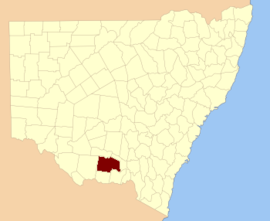
Waradgery County is one of the 141 Cadastral divisions of New South Wales. It contains the town of Hay. It includes the area between the Lachlan River and the Murrumbidgee River where they meet. The Lachlan River is the northern boundary of the county, and the Murrumbidgee for a small section is the southern boundary, but the county also includes some of the land to the south of the Murrumbidgee near Hay.

Irrara County Cadastral in New South Wales, Australia

Irrara County is one of the 141 Cadastral divisions of New South Wales. It is located south of the border with Queensland, east of the Paroo River, and west of the Warrego River.

Mootwingee County Cadastral in New South Wales, Australia

Mootwingee County, New South Wales is one of the 141 Cadastral divisions of New South Wales.

Gunderman, New South Wales Town in New South Wales, Australia

Gunderman is a locality of the Central Coast region of New South Wales, Australia, located on the north bank of the Hawkesbury River between the towns of Wisemans Ferry and Spencer. It is located within the Central Coast Council local government area. It adjoins the Dharug National Park. At the 2006 census, Gunderman had a population of 137 people.

Lake Urana Nature Reserve Protected area in New South Wales, Australia

The Lake Urana Nature Reserve is a protected nature reserve situated adjacent to Lake Urana, a salt lake, that is located in the Riverina region of New South Wales in eastern Australia. The 302-hectare (750-acre) reserve is situated near the rural locality of Urana. The 6,100-hectare (15,000-acre) lake is shallow and intermittently filled by flooding that forms in a natural depression. The lake fills every 10 to 20 years and retains water for several years; with no natural outflow, it is drained via evaporation.

Boorowa River

Boorowa River, a perennial stream that is part of the Lachlan catchment within the Murray–Darling basin, is located in the central–western region of New South Wales, Australia.

Bredbo River, a perennial stream that is part of the Murrumbidgee catchment within the Murray–Darling basin, is located in the Monaro region of New South Wales, Australia.

Merriwa River, a perennial river of the Hunter River catchment, is located in the Upper Hunter region of New South Wales, Australia.

Kundabung, New South Wales Town in New South Wales, Australia

Kundabung is a locality on the North Coast of New South Wales, Australia.

Dingo Creek, a perennial stream of the Manning River catchment, is located in the Mid North Coast region of New South Wales, Australia.

Ourimbah Creek

Ourimbah Creek, a perennial river of the Central Coast catchment, is located in the Central Coast region of New South Wales, Australia.

Currawang Cadastral in New South Wales, Australia

Currawang is a locality in the Queanbeyan–Palerang Regional Council, on the edges of Upper Lachlan Shire and Goulburn-Mulwaree Council, in New South Wales, Australia. It is located to the north of Lake George. It shares its name with the Currawang Parish of Argyle County, in which it is located. This was formerly known as the parish of Currowang. Both names derive from an Aboriginal word for the spearwood tree.

Federation Council, New South Wales Local government area in New South Wales, Australia

The Federation Council is a local government area located in the Riverina region of New South Wales, Australia. This area was formed in 2016 from the merger of the Corowa Shire with its neighbouring Urana Shire.

References

  1. "Urana". Geographical Names Register (GNR) of NSW. Geographical Names Board of New South Wales . Retrieved 11 August 2013. OOjs UI icon edit-ltr-progressive.svg
  2. Jervis, James, 'The Western Riverina: A History of Its Development', Royal Australian Historical Society Journal and Proceedings, Vol. XXXVIII 1952, pp. 242-3.
  3. The New atlas of Australia (John Sands 1886) map 21.