Mitchell County, New South Wales

Last updated

Map all coordinates using: OpenStreetMap  
Download coordinates as: KML  ·  GPX
Mitchell
New South Wales
Mitchell NSW.PNG
Location in New South Wales
Lands administrative divisions around Mitchell:
Cooper Bourke Clarendon
Urana Mitchell Wynyard
Urana Hume Goulburn

Mitchell County is one of the 141 Cadastral divisions of New South Wales. It contains the town of Collingullie. The Murrumbidgee River is the northern boundary.

Mitchell County is named in honour of the Surveyor-General Sir Thomas Livingstone Mitchell (1792-1855). [1]

Parishes within this county

A full list of parishes found within this county; their current LGA and mapping coordinates to the approximate centre of each location is as follows:

ParishLGACoordinates
Arajoel City of Wagga Wagga 35°01′54″S146°50′04″E / 35.03167°S 146.83444°E / -35.03167; 146.83444 (Arajoel)
Ashcroft Lockhart Shire Council 35°13′54″S146°53′04″E / 35.23167°S 146.88444°E / -35.23167; 146.88444 (Ashcroft)
Berry Jerry City of Wagga Wagga 35°02′54″S147°00′04″E / 35.04833°S 147.00111°E / -35.04833; 147.00111 (Berry Jerry)
Birrego Narrandera Shire Council 34°56′54″S146°35′04″E / 34.94833°S 146.58444°E / -34.94833; 146.58444 (Birrego)
Brewarrina Narrandera Shire Council 34°51′54″S146°45′04″E / 34.86500°S 146.75111°E / -34.86500; 146.75111 (Brewarrena)
Buckinbong Narrandera Shire Council 34°51′54″S146°41′04″E / 34.86500°S 146.68444°E / -34.86500; 146.68444 (Buckinbong)
Bulgary City of Wagga Wagga 35°00′54″S146°57′04″E / 35.01500°S 146.95111°E / -35.01500; 146.95111 (Bulgary)
Bullenbung Lockhart Shire Council 35°07′54″S147°00′04″E / 35.13167°S 147.00111°E / -35.13167; 147.00111 (Bullenbung)
Burke Lockhart Shire Council 35°17′54″S147°10′04″E / 35.29833°S 147.16778°E / -35.29833; 147.16778 (Burke)
Burrandana City of Wagga Wagga 35°23′54″S147°22′04″E / 35.39833°S 147.36778°E / -35.39833; 147.36778 (Burrandana)
Coffin Rock City of Wagga Wagga 35°21′54″S147°18′04″E / 35.36500°S 147.30111°E / -35.36500; 147.30111 (Coffin Rock)
Corobimilla Narrandera Shire Council 34°52′54″S146°23′04″E / 34.88167°S 146.38444°E / -34.88167; 146.38444 (Corobimilla)
Cox Lockhart Shire Council 35°22′54″S147°08′04″E / 35.38167°S 147.13444°E / -35.38167; 147.13444 (Cox)
Cuddell Narrandera Shire Council 34°48′54″S146°24′04″E / 34.81500°S 146.40111°E / -34.81500; 146.40111 (Cuddell)
Edgehill Lockhart Shire Council 35°28′54″S147°01′04″E / 35.48167°S 147.01778°E / -35.48167; 147.01778 (Edgehill)
Faithfull Narrandera Shire Council 34°57′54″S146°41′04″E / 34.96500°S 146.68444°E / -34.96500; 146.68444 (Faithfull)
Gillenbah Narrandera Shire Council 34°44′54″S146°30′04″E / 34.74833°S 146.50111°E / -34.74833; 146.50111 (Gillenbah)
Gobbagaula Narrandera Shire Council 34°51′54″S146°36′04″E / 34.86500°S 146.60111°E / -34.86500; 146.60111 (Gobbagaula)
Grubben Lockhart Shire Council 35°24′54″S147°00′04″E / 35.41500°S 147.00111°E / -35.41500; 147.00111 (Grubben)
Hanging Rock Lockhart Shire Council 35°15′54″S147°03′04″E / 35.26500°S 147.05111°E / -35.26500; 147.05111 (Hanging Rock)
Leitch Lockhart Shire Council 35°14′54″S147°07′04″E / 35.24833°S 147.11778°E / -35.24833; 147.11778 (Leitch)
Maclean City of Wagga Wagga 35°26′54″S147°15′04″E / 35.44833°S 147.25111°E / -35.44833; 147.25111 (Maclean)
Mangoplah City of Wagga Wagga 35°22′54″S147°15′04″E / 35.38167°S 147.25111°E / -35.38167; 147.25111 (Mangoplah)
Milbrulong Lockhart Shire Council 35°18′54″S146°55′04″E / 35.31500°S 146.91778°E / -35.31500; 146.91778 (Milbrulong)
Mimosa Narrandera Shire Council 35°00′54″S146°46′04″E / 35.01500°S 146.76778°E / -35.01500; 146.76778 (Mimosa)
Mundawaddery Lockhart Shire Council 35°23′54″S146°53′04″E / 35.39833°S 146.88444°E / -35.39833; 146.88444 (Mundawaddery)
Mundowy City of Wagga Wagga 35°06′54″S147°06′04″E / 35.11500°S 147.10111°E / -35.11500; 147.10111 (Mundowy)
Osborne City of Wagga Wagga 35°07′54″S146°54′04″E / 35.13167°S 146.90111°E / -35.13167; 146.90111 (Osborne)
Pearson City of Wagga Wagga 35°15′54″S147°11′04″E / 35.26500°S 147.18444°E / -35.26500; 147.18444 (Pearson)
Pulletop City of Wagga Wagga 35°26′54″S147°22′04″E / 35.44833°S 147.36778°E / -35.44833; 147.36778 (Pulletop)
Sandy Creek City of Wagga Wagga 35°15′54″S147°18′04″E / 35.26500°S 147.30111°E / -35.26500; 147.30111 (Sandy Creek)
Tootool Lockhart Shire Council 35°14′54″S147°00′04″E / 35.24833°S 147.00111°E / -35.24833; 147.00111 (Tootool)
Uranquinty City of Wagga Wagga 35°06′54″S147°15′04″E / 35.11500°S 147.25111°E / -35.11500; 147.25111 (Uranquinty)
Vincent Lockhart Shire Council 35°20′54″S147°00′04″E / 35.34833°S 147.00111°E / -35.34833; 147.00111 (Vincent)
Wauberrima City of Wagga Wagga 34°56′54″S146°51′04″E / 34.94833°S 146.85111°E / -34.94833; 146.85111 (Wauberrima)
Westby City of Wagga Wagga 35°26′54″S147°27′04″E / 35.44833°S 147.45111°E / -35.44833; 147.45111 (Westby)
Wood Narrandera Shire Council 34°52′54″S146°30′04″E / 34.88167°S 146.50111°E / -34.88167; 146.50111 (Wood)
Yarabee Narrandera Shire Council 34°44′54″S146°26′04″E / 34.74833°S 146.43444°E / -34.74833; 146.43444 (Yarabee)
Yarragundry City of Wagga Wagga 35°08′54″S147°12′04″E / 35.14833°S 147.20111°E / -35.14833; 147.20111 (Yarragundry)
Yerong Lockhart Shire Council 35°24′54″S147°05′04″E / 35.41500°S 147.08444°E / -35.41500; 147.08444 (Yerong)

Related Research Articles

Thomas Mitchell (explorer) Scottish surveyor and explorer in Australia

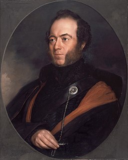
Sir Thomas Livingstone Mitchell, surveyor and explorer of south-eastern Australia, was born at Grangemouth in Stirlingshire, Scotland. In 1827 he took up an appointment as Assistant Surveyor General of New South Wales. The following year he became Surveyor General and remained in this position until his death. Mitchell was knighted in 1839 for his contribution to the surveying of Australia.

Peel River (New South Wales) river in Australia

Peel River, a watercourse that is part of the Namoi catchment within the Murray–Darling basin, is located in the North West Slopes and Plains district of New South Wales, Australia.

Barwon River (New South Wales) river located in the Orana region of New South Wales, Australia

Barwon River, a perennial river that is part of the Murray–Darling basin, is located in the north-west slopes and Orana regions of New South Wales, Australia.

The Geographical Names Board of New South Wales, a statutory authority of the Land and Property Information division, Department of Finance and Services in the Government of New South Wales, is the official body for naming and recording details of places and geographical names in the state of New South Wales, Australia.

Woronora River river in New South Wales, Australia

The Woronora River is a perennial river of the Sydney Basin, located in the Sutherland Shire local government area of Greater Metropolitan Sydney, approximately 22 kilometres (14 mi) south of the Sydney central business district, in New South Wales, Australia.

Goobang Creek river in New South Wales, Australia

The Goobang Creek, a perennial stream of the Lachlan sub–catchment, part of the Murrumbidgee catchment of the Murray-Darling basin, is located in the Central West region of New South Wales, Australia.

Lands administrative divisions of New South Wales Wikimedia list article

The lands administrative divisions of New South Wales refers to the 141 counties within the Colony of New South Wales, that later became the Australian state of New South Wales.

Townsend County Cadastral in New South Wales, Australia

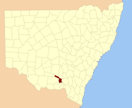
Townsend County is one of the 141 Cadastral divisions of New South Wales. It is in the south of New South Wales with the Murray River to the south. Deniliquin is located there.

Lachlan Valley Way highway in New South Wales

Lachlan Valley Way is a New South Wales state highway running from Booligal on the Cobb Highway to north of Yass on the Hume Highway (M31).

Mount Lindesay (New South Wales) mountain in New South Wales, Australia

Mount Lindesay, sometimes incorrectly recorded as Mount Lindsay, a mountain located within the Nandewar Range, is situated within the North West Slopes region of New South Wales, Australia. The mountain was formed by the Nandewar extinct volcano which ceased activity about 17 million years ago after 4 million years of activity.

Moonie River river in Australia

The Moonie River is a river in Shire of Balonne, Queensland and Walgett Shire, New South Wales, both in Australia. It is a perennial river of the Barwon catchment within the Murray–Darling basin.

Barnard River river in Australia

Barnard River, a perennial river of the Manning River catchment, is located in the Northern Tablelands and Mid North Coast districts of New South Wales, Australia.

Henry River, a perennial stream of the Clarence River catchment, is located in the Northern Tablelands district of New South Wales, Australia.

Sara River, a perennial stream that is part of the Clarence River catchment, is located in the New England and Northern Tablelands districts of New South Wales, Australia.

Manning Point, New South Wales Town in New South Wales, Australia

Manning Point is a small village located at the mouth of the Manning River in New South Wales, Australia. Lying on Mitchells Island, it lies opposite the town of Harrington. It is 26 kilometres (16 mi) east of Taree on the Mid North Coast. At the 2006 census, Manning Point had a population of 228.

James Charles Burnett Australian surveyor

James Charles Burnett (1815—1854) a.k.a. "John" was a surveyor and explorer in New South Wales, Australia. He was the head of the first Survey Office established at Brisbane in 1844.

Numurkah, New South Wales

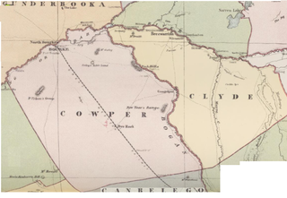
Numurkah, New South Wales is a Bounded locality of Bourke Shire and a civil Parish of Cowper County, New South Wales, a cadasteral division of central New South Wales.

Runnymede Parish (Cowper County), New South Wales

Runnymede Parish, New South Wales is a Bounded locality of Bogan Shire and a civil Parish of Cowper County, New South Wales, a cadasteral division of central New South Wales.

Medway Parish (Cowper County), New South Wales

Medway Parish, New South Wales is a Bounded locality of Bogan Shire and a civil Parish of Cowper County, New South Wales, a cadasteral division of central New South Wales.

Maffra, New South Wales Parish of Cowper County, New South Wales, Australia

Maffra Parish, New South Wales is a Bounded locality of Bourke Shire and a civil Parish of Cowper County, New South Wales, a cadasteral division of central New South Wales.

References

  1. "Mitchell County". Geographical Names Register (GNR) of NSW. Geographical Names Board of New South Wales. OOjs UI icon edit-ltr-progressive.svg