Clarendon County, New South Wales

Last updated
Map all coordinates using: OpenStreetMap  ·  Google Maps
Download coordinates as: KML  ·  GPX
Clarendon
New South Wales

Clarendon NSW.PNG

Location in New South Wales
Lands administrative divisions around Clarendon:
Bourke Bland Bland
Bourke Clarendon Harden
Mitchell Wynyard Buccleuch

Clarendon County is one of the 141 Cadastral divisions of New South Wales. It contains the towns of Gundagai, Junee and Bethungra. The Murrumbidgee River is the boundary to the south.

Murrumbidgee River river in New South Wales, Australia

Murrumbidgee River, a major tributary of the Murray River within the Murray–Darling basin and the second longest river in Australia. It flows through the Australian state of New South Wales and the Australian Capital Territory. It descends 1,500 metres (4,900 ft) as it flows 1,485 kilometres (923 mi) in a west-northwesterly direction from the foot of Peppercorn Hill in the Fiery Range of the Snowy Mountains towards its confluence with the Murray River near Boundary Bend.

Clarendon County was named in honour of George William Frederick Villiers, 4th Earl Clarendon (1800-1870). [1]

The Murrumbidgee River at Gundagai; the boundary between Clarendon and Wynyard MurrumbidgeeAtGundagai.jpg
The Murrumbidgee River at Gundagai; the boundary between Clarendon and Wynyard

Parishes within this county

A full list of parishes found within this county; their current LGA and mapping coordinates to the approximate centre of each location is as follows:

Local government in Australia

Local government in Australia is the third tier of government in Australia administered by the states and territories, which in turn are beneath the federal tier. Local government is not mentioned in the Constitution of Australia and two referenda in the 1970s and 1980s to alter the Constitution relating to local government were unsuccessful. Every state government recognises local government in their respective constitutions. Unlike Canada or the United States, there is only one level of local government in each state, with no distinction such as cities and counties.

Parish LGA Coordinates
Bethungra Junee Shire Council 34°43′54″S147°50′04″E / 34.73167°S 147.83444°E / -34.73167; 147.83444 (Bethungra)
Bilda Junee Shire Council 35°04′54″S147°39′04″E / 35.08167°S 147.65111°E / -35.08167; 147.65111 (Bilda)
Billabung Junee Shire Council 34°47′54″S147°48′04″E / 34.79833°S 147.80111°E / -34.79833; 147.80111 (Billabung)
Boree Junee Shire Council 34°50′54″S147°39′04″E / 34.84833°S 147.65111°E / -34.84833; 147.65111 (Boree)
Bulgan City of Wagga Wagga 34°57′54″S147°20′04″E / 34.96500°S 147.33444°E / -34.96500; 147.33444 (Bulgan)
Bute Junee Shire Council 34°35′54″S147°46′04″E / 34.59833°S 147.76778°E / -34.59833; 147.76778 (Bute)
Claris Junee Shire Council 34°59′54″S147°40′04″E / 34.99833°S 147.66778°E / -34.99833; 147.66778 (Claris)
Cooba Junee Shire Council 34°55′54″S147°52′04″E / 34.93167°S 147.86778°E / -34.93167; 147.86778 (Cooba)
Eunanoreenya City of Wagga Wagga 35°03′54″S147°29′04″E / 35.06500°S 147.48444°E / -35.06500; 147.48444 (Eunanoreenya)
Eurongilly Junee Shire Council 34°55′54″S147°45′04″E / 34.93167°S 147.75111°E / -34.93167; 147.75111 (Eurongilly)
Gobbagombalin City of Wagga Wagga 35°02′54″S147°18′04″E / 35.04833°S 147.30111°E / -35.04833; 147.30111 (Gobbagombalin)
Gwynne Junee Shire Council 34°47′54″S147°30′04″E / 34.79833°S 147.50111°E / -34.79833; 147.50111 (Gwynne)
Houlaghan Junee Shire Council 34°43′40″S147°32′43″E / 34.72778°S 147.54528°E / -34.72778; 147.54528 (Houlaghan)
Hurley Junee Shire Council 34°36′54″S147°41′04″E / 34.61500°S 147.68444°E / -34.61500; 147.68444 (Hurley)
Ironbong Junee Shire Council 34°44′54″S147°45′04″E / 34.74833°S 147.75111°E / -34.74833; 147.75111 (Ironbong)
Ivor Junee Shire Council 34°44′54″S147°40′04″E / 34.74833°S 147.66778°E / -34.74833; 147.66778 (Ivor)
Jeralgambeth Junee Shire Council 34°59′54″S147°35′04″E / 34.99833°S 147.58444°E / -34.99833; 147.58444 (Jeralgambeth)
Junee Junee Shire Council 34°47′54″S147°33′04″E / 34.79833°S 147.55111°E / -34.79833; 147.55111 (Junee)
Kimo Cootamundra-Gundagai Regional Council 35°02′54″S148°00′04″E / 35.04833°S 148.00111°E / -35.04833; 148.00111 (Kimo)
Malebo Junee Shire Council 34°55′54″S147°23′04″E / 34.93167°S 147.38444°E / -34.93167; 147.38444 (Malebo)
Maror Junee Shire Council 34°50′54″S147°28′04″E / 34.84833°S 147.46778°E / -34.84833; 147.46778 (Maror)
Merrybundinah Junee Shire Council 34°51′54″S147°48′04″E / 34.86500°S 147.80111°E / -34.86500; 147.80111 (Merrybundinah)
Mitta Mitta Junee Shire Council 34°51′54″S147°54′04″E / 34.86500°S 147.90111°E / -34.86500; 147.90111 (Mitta Mitta)
Nangus Cootamundra-Gundagai Regional Council 35°00′54″S147°57′04″E / 35.01500°S 147.95111°E / -35.01500; 147.95111 (Nangus)
North Gundagai Cootamundra-Gundagai Regional Council 35°00′54″S148°04′04″E / 35.01500°S 148.06778°E / -35.01500; 148.06778 (North Gundagai)
North Wagga Wagga City of Wagga Wagga 35°03′54″S147°23′04″E / 35.06500°S 147.38444°E / -35.06500; 147.38444 (North Wagga Wagga)
Oura City of Wagga Wagga 35°03′54″S147°33′04″E / 35.06500°S 147.55111°E / -35.06500; 147.55111 (Oura)
Sebastopol Temora Shire Council 34°35′54″S147°34′04″E / 34.59833°S 147.56778°E / -34.59833; 147.56778 (Sebastopol)
South Junee Junee Shire Council 34°53′54″S147°31′04″E / 34.89833°S 147.51778°E / -34.89833; 147.51778 (South Junee)
Tenandra Junee Shire Council 34°59′54″S147°50′04″E / 34.99833°S 147.83444°E / -34.99833; 147.83444 (Tenandra)
Trevethin Junee Shire Council 34°40′54″S147°40′04″E / 34.68167°S 147.66778°E / -34.68167; 147.66778 (Trevethin)
Ulandra Junee Shire Council 34°45′54″S147°54′04″E / 34.76500°S 147.90111°E / -34.76500; 147.90111 (Ulandra)
Wallace City of Wagga Wagga 34°57′54″S147°28′04″E / 34.96500°S 147.46778°E / -34.96500; 147.46778 (Wallace)
Wantabadgery Junee Shire Council 34°59′54″S147°45′04″E / 34.99833°S 147.75111°E / -34.99833; 147.75111 (Wantabadgery)
Wantiool Junee Shire Council 34°54′54″S147°39′04″E / 34.91500°S 147.65111°E / -34.91500; 147.65111 (Wantiool)
Warre Warral Junee Shire Council 34°38′54″S147°32′04″E / 34.64833°S 147.53444°E / -34.64833; 147.53444 (Warre Warral)

Related Research Articles

Clarendon, Texas City in Texas, United States

Clarendon is a city in Donley County, Texas, United States. The population was 2,026 at the 2010 census. The county seat of Donley County, Clarendon is located on U.S. Highway 287 in the Texas Panhandle, 60 miles (97 km) east of Amarillo.

Clarendon may refer to:

South Creek (New South Wales) river in New South Wales, Australia

The South Creek or Wianamatta, a creek that is part of the Hawkesbury-Nepean catchment, is located on the Cumberland Plain, also referred to as Greater Western Sydney, New South Wales, Australia.

The Geographical Names Board of New South Wales, a statutory authority of the Land and Property Information division, Department of Finance and Services in the Government of New South Wales, is the official body for naming and recording details of places and geographical names in the state of New South Wales, Australia.

Eurongilly, New South Wales Town in New South Wales, Australia

Eurongilly is a locality in the central part of the Riverina and situated about 19 kilometres north west of Nangus and 21 kilometres south east of Junee.

Darbalara, New South Wales Town in New South Wales, Australia

Darbalara is a rural community on the east bank of the junction of the Murrumbidgee River and Tumut River in the Riverina. It is situated by road, about 25 kilometres north east of Gundagai and 25 kilometres south of Coolac.

Gloucester County, New South Wales Cadastral in New South Wales, Australia

Gloucester County was one of the original Nineteen Counties in New South Wales, and is now one of the 141 cadastral divisions of New South Wales. It includes the area around Port Stephens. It is bounded on the north and west by the Manning River, and on the south-west by the Williams River.

Northumberland County, New South Wales Cadastral in New South Wales, Australia

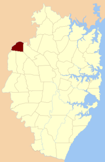
Northumberland County was one of the original Nineteen Counties in New South Wales and is now one of the 141 Cadastral divisions of New South Wales. It included the area to the north of Broken Bay, including Lake Macquarie and Newcastle. It was bounded by the part of the Hawkesbury River to the south, the Macdonald River to the south-west, and the Hunter River to the north.

Camden County, New South Wales Cadastral in New South Wales, Australia

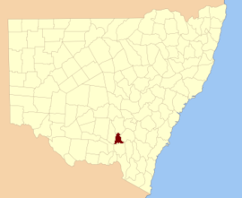
Camden County was one of the original Nineteen Counties in New South Wales and is now one of the 141 Cadastral divisions of New South Wales. It included the coastal area near Wollongong south to the Shoalhaven River, and also inland encompassing Berrima and Picton. Its western boundary was the Wollondilly River. The first settlement in the area was Camden Park, established by John Macarthur in 1806, just across the Nepean River from Cumberland County. It was the first land across the Nepean to be settled. Camden is a present-day suburb of Sydney in the same area, although parts of it are in Cumberland.

St Vincent County Cadastral in New South Wales, Australia

St Vincent County was one of the original Nineteen Counties in New South Wales and is now one of the 141 Cadastral divisions of New South Wales. It included the south coast area encompassing Batemans Bay, Ulladulla, Jervis Bay and inland to Braidwood. The Shoalhaven River is the boundary to the north and west, and the Deua River the boundary to the south.

Cowper County Cadastral in New South Wales, Australia

Cowper County, New South Wales is one of the 141 Cadastral divisions of New South Wales.

Gowen County Cadastral in New South Wales, Australia

Gowen County is one of the 141 Cadastral divisions of New South Wales. It is located to the east of the Castlereagh River in the area to the east of Gilgandra, to Coonabarabran in the north-east. This includes land on both sides of the Newell Highway.

Irrara County Cadastral in New South Wales, Australia

Irrara County is one of the 141 Cadastral divisions of New South Wales. It is located south of the border with Queensland, east of the Paroo River, and west of the Warrego River.

Kennedy County Cadastral in New South Wales, Australia

Kennedy County is one of the 141 Cadastral divisions of New South Wales. It is located to the west of the Bogan River in the area around Tottenham and Tullamore.

Mootwingee County Cadastral in New South Wales, Australia

Mootwingee County, New South Wales is one of the 141 Cadastral divisions of New South Wales.

Oxley County Cadastral in New South Wales, Australia

Oxley County, New South Wales is one of the 141 Cadastral divisions of New South Wales. It is located between the Bogan River on the west, and the Macquarie River on the east. This is the area approximately between Warren and Nyngan.

Cobrabald River river in Australia

Cobrabald River, a mostly perennial river that is part of the Namoi catchment within the Murray–Darling basin, is located in the Northern Tablelands district of New South Wales, Australia.

Blowering, New South Wales

Blowering, New South wales is a rural locality in the Snowy Mountains of New South wales and a civil Parish of Buccleuch County.

Parish of Ham Common

The parish of Ham Common is one of the 57 civil parishs of the County of Cumberland, New South Wales.

References

  1. "Clarendon County". Geographical Names Register (GNR) of NSW. Geographical Names Board of New South Wales.