Gobbagombalin is a predominantly farming community in the central east part of the Riverina and a suburb of Wagga Wagga.[2] A portion of Gobbagombalin adjacent to the suburb of Estella and to the North of Old Narrandera Road was rezoned for residential purposes under the Wagga Wagga Local Environmental Plan 2010 in July 2010,[3] with suburban development of area commencing in 2013. The suburban part of Gobbagombalin is being marketed under various names including Estella Rise and Estella Heights, as well as Gobbagombalin, despite Estella being a separate locality further to the east of Gobbagombalin.[4][5]
The name Gobbagombalin is associated with the a traditional Wiradjuri story concerning two individuals, Gobbagumbalin, a young man and Pomingalarna, a young woman, who broke traditional law, and were punished with death. According to the story, reminder of the death of the couple can be found in the mourning chant of the local frogs.[6][7]
Streets in the suburban area of Gobbagombalin are named after Riverina parish names.[8]
The Wiradjuri people are a group of Aboriginal Australian people who were united by a common language, strong ties of kinship and survived as skilled hunter–fisher–gatherers in family groups or clans scattered throughout central New South Wales.
Murrumbidgee River, a major tributary of the Murray River within the Murray–Darling basin and the second longest river in Australia. It flows through the Australian state of New South Wales and the Australian Capital Territory. It descends 1,500 metres (4,900 ft) as it flows 1,485 kilometres (923 mi) in a west-northwesterly direction from the foot of Peppercorn Hill in the Fiery Range of the Snowy Mountains towards its confluence with the Murray River near Boundary Bend.
Wagga Wagga is a major regional city in the Riverina region of New South Wales, Australia. Straddling the Murrumbidgee River, with an urban population of more than 56,000 as at June 2018, Wagga Wagga is the state's largest inland city, and is an important agricultural, military, and transport hub of Australia. The ninth fastest growing inland city in Australia, Wagga Wagga is located midway between the two largest cities in Australia–Sydney and Melbourne–and is the major regional centre for the Riverina and South West Slopes regions.
The Riverina is an agricultural region of South-Western New South Wales (NSW), Australia. The Riverina is distinguished from other Australian regions by the combination of flat plains, warm to hot climate and an ample supply of water for irrigation. This combination has allowed the Riverina to develop into one of the most productive and agriculturally diverse areas of Australia. Bordered on the south by the state of Victoria and on the east by the Great Dividing Range, the Riverina covers those areas of New South Wales in the Murray and Murrumbidgee drainage zones to their confluence in the west.
Cootamundra is a town in the South West Slopes region of New South Wales, Australia and within the Riverina. It is within the Cootamundra-Gundagai Regional Council. At the 2016 Census, Cootamundra had a population of 6,782. It is located on the Olympic Highway at the point where it crosses the Muttama Creek, between Junee and Cowra. Cootamundra is not on the Hume Highway, but its railway station is on the Main Southern line, part of the Melbourne-to-Sydney line. Abb McAlister was elected mayor of the newly-formed Cootamundra-Gundagai Regional Council on 21 September 2017.
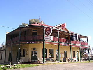
Coolac is a village in the Riverina region of New South Wales, Australia in Gundagai Council. At the 2011 census, Coolac had a population of 216.
Turvey Park is an inner southern suburb of Wagga Wagga in southern New South Wales, Australia. Its boundaries are defined by Fernleigh Road to the south, Glenfield Road to the west, Coleman Street to the north and to the east by Willans Hill. Turvey Park is characterised by single detached dwellings, constructed in the period from the early 1900s through to the 1960s. These dwellings vary from the very substantial, as found in parts of Coleman Street and Grandview Parade, to the brick bungalows of the northern end of the suburb between Urana and Coleman Streets, to modest public housing, and a mixture of brick and fibro and weatherboard cottages at the southern end of the suburb. Another feature of Turvey Park are many corner shops, such on the corner of Heath and Urana Street, the corner of Norman and Coleman Streets, and the Corner of Bourke and Urana Streets.
Bomen is a northern suburb of Wagga Wagga in southern New South Wales, Australia. The suburb is dominated by industrial enterprises including Cargill Beef, Watties, the Wagga Wagga Livestock Marketing Centre (saleyards). The suburb is also home to Wagga Wagga's secondary railway station on the Main Southern line, when the line waited for the construction of a bridge over the Murrumbidgee River. New streets in Bomen are to be named after sheep and cattle breeds.
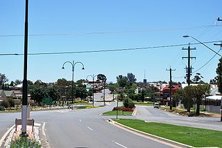
Coolamon is a town in the Riverina region of south-west New South Wales, Australia. Coolamon is 40 kilometres (25 mi) north-west of Wagga Wagga and 506 kilometres (314 mi) south-west of Sydney via the Hume and Sturt Highways. The town is situated on the railway line between Junee and Narrandera. Coolamon had a population of 2,199 at the 2016 census and is 290 metres (950 ft) above sea level. It is the administrative and service centre for the local government area which bears its name—Coolamon Shire.
Culcairn is a town in the south-east Riverina region of New South Wales, Australia. Culcairn is located in the Greater Hume Shire local government area on the Olympic Highway between Albury and Wagga Wagga. The town is 514 kilometres (319 mi) south-west of the state capital, Sydney and at the 2006 census had a population of 1,120. Culcairn is more commonly known throughout the region as 'The Oasis of the Riverina'.
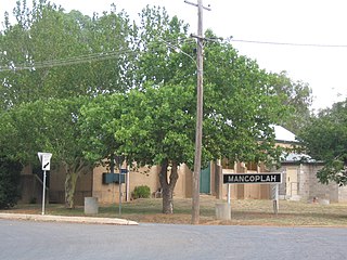
Mangoplah is a town approximately 36 kilometres (22 mi) south of Wagga Wagga in the Riverina region of New South Wales, Australia. At the 2016 census, Mangoplah had a population of 309. The name of the town is believed to mean "Kooris singing" in the Wiradjuri aboriginal language.
City of Wagga Wagga is a local government area in the Riverina region of south-western New South Wales, Australia.
Ganmain is a town in the Riverina region of New South Wales, Australia. Ganmain is located around 55 kilometres (34 mi) north west of Wagga Wagga, and 50 kilometres (31 mi) east of Narrandera. Ganmain is in the Coolamon Shire local government area and had a population at the 2016 census of 779.
Downside is a farming community in the central east part of the Riverina and situated about 15 kilometres north west from Wagga Wagga and 24 kilometres south east from Coolamon.
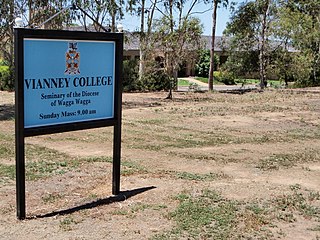
Boorooma is a suburb of Wagga Wagga, New South Wales, Australia, located in the city's north, beyond the floodplains of the Murrumbidgee River. The locality is a southern neighbour of Charles Sturt University—which in fact is referred to as 'Boorooma Campus' and is located directly to the east of the suburb of Estella and to the north of the Olympic Highway. Boorooma is progressively undergoing transition from rural residential type allotments to more intensive urban residential uses. Boorooma is also home to Vianney College Seminary and The Riverina Anglican College, and has land zoned for a future shopping centre.
The history of Wagga Wagga details the growth of the city from a small crossing on the Murrumbidgee River to the largest city and regional centre of the Riverina region of New South Wales, Australia.
East Wagga Wagga is a suburb of Wagga Wagga, New South Wales. East Wagga Wagga is mostly an industrial area located approximately 3 km (2 mi) east south-east of the central business district on the Sturt Highway. Home Base Wagga Wagga, WIN Television, Country Energy depot, Riverina Water County Council headquarters, Australia Post Mail Sorting Centre, Busabout Wagga Wagga depot, Australian Clay Target Association (ACTA) National Office and ACTA shooting range are located within East Wagga Wagga.
The Gap is a farming community in the central east part of the Riverina close to Wagga Wagga.
Dhulura is a rural area in the New South Wales Riverina close to Wagga Wagga. The locality was gazetted in 2015, and is named after the former Dhulura School which was located in the area
This page is based on this Wikipedia article Text is available under the CC BY-SA 4.0 license; additional terms may apply. Images, videos and audio are available under their respective licenses.