
The Murrumbidgee River is a major tributary of the Murray River within the Murray–Darling basin and the second longest river in Australia. It flows through the Australian state of New South Wales and the Australian Capital Territory, descending 1,500 metres (4,900 ft) over 1,485 kilometres (923 mi), generally in a west-northwesterly direction from the foot of Peppercorn Hill in the Fiery Range of the Snowy Mountains towards its confluence with the Murray River near Boundary Bend.

Wagga Wagga is a major regional city in the Riverina region of New South Wales, Australia. Straddling the Murrumbidgee River, with an urban population of more than 56,000 as of June 2018, Wagga Wagga is the state's largest inland city, and is an important agricultural, military, and transport hub of Australia. The ninth largest inland city in Australia, Wagga Wagga is located midway between the two largest cities in Australia—Sydney and Melbourne—and is the major regional centre for the Riverina and South West Slopes regions.

The Olympic Highway is a rural road in the central western and south-eastern Riverina regions of New South Wales, Australia. The 318-kilometre (198 mi) highway services rural communities and links the Hume Highway with the Mid-Western Highway and provides part of an alternate road link between Sydney and Albury via Bathurst and Cowra as well as servicing Wagga Wagga, linking with the Sturt Highway.

Glenfield Park, or simply 'Glenfield' is a rapidly growing southern suburb of Wagga Wagga, New South Wales, Australia reaching its final stages of development. Glenfield Park's strong residential development is due to its situation so close to the outskirts of the city and availability of relatively flat, cheap land. The suburb is home to the city's first Aldi supermarket and a large shopping centre known as South City Shopping Centre that is home to Wagga's second Coles supermarket.
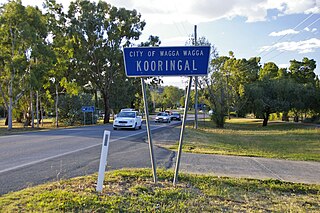
Kooringal is a suburb of Wagga Wagga, New South Wales, Australia. Kooringal is thought to mean "Side of a Hill" in the Wiradjuri aboriginal language. Kooringal is located approximately 4 km from the CBD along Lake Albert Road. Kooringal is the basis for growth in the eastern section of Wagga Wagga. Kooringal High School, on Ziegler Avenue is the largest secondary school in Wagga Wagga. The Kooringal area is also home to other schools including Kooringal Public School, Sturt Public School and the Sacred Heart School. Kooringal has a large suburban shopping centre known as Kooringal Mall and it consists of a Woolworths supermarket, McDonald's, Subway, Domino's Pizza, Australia Post retail store and various specialty stores.

Mount Austin is an inner southern suburb of Wagga Wagga, New South Wales, Australia. Its boundaries are Fernleigh Road and Leavenworth Drive to the north and south respectively, whilst Glenfield Road and Willans Hill form the western and eastern extents.

Bourkelands is a rapidly developing southern suburb of Wagga Wagga in southern New South Wales, Australia which is named after a property which was located within the suburb. The suburb consists predominantly of real estate display homes and housing for military staff at the nearby RAAF Base Wagga and Army Recruit Training Centre. The suburb borders Red Hill Road and is within walking distance of the Tolland shopping centre and Jubilee Park/Oval and contains two play parks. The suburb also contains the area which is commonly marketed by real estate agents and developers as Hilltop, as the name Hilltop is not registered locality.

Turvey Park is an inner southern suburb of Wagga Wagga in southern New South Wales, Australia. Its boundaries are defined by Fernleigh Road to the south, Glenfield Road to the west, Coleman Street to the north and to the east by Willans Hill. Turvey Park is characterised by single detached dwellings, constructed in the period from the early 1900s through to the 1960s. These dwellings vary from the very substantial, as found in parts of Coleman Street and Grandview Parade, to the brick bungalows of the northern end of the suburb between Urana and Coleman Streets, to modest public housing, and a mixture of brick and fibro and weatherboard cottages at the southern end of the suburb. Another feature of Turvey Park are many corner shops, such on the corner of Heath and Urana Street, the corner of Norman and Coleman Streets, and the Corner of Bourke and Urana Streets.

Bomen is a northern suburb of Wagga Wagga in southern New South Wales, Australia. The suburb is dominated by industrial enterprises including Cargill Beef, Watties, the Wagga Wagga Livestock Marketing Centre (saleyards). The suburb is also home to Wagga Wagga's secondary railway station on the Main Southern line, when the line waited for the construction of a bridge over the Murrumbidgee River. New streets in Bomen are to be named after sheep and cattle breeds.
San Isidore is a rural suburb located on the outskirts of the city of Wagga Wagga, New South Wales, Australia.

Forest Hill is a suburb of Wagga Wagga, New South Wales. Forest Hill is located approximately 10 km east of the central business district on the Sturt Highway. RAAF Base Wagga, Wagga Wagga Airport and the Bureau of Meteorology Regional Office are located at Forest Hill.

Collingullie is a village 26 kilometres (16 mi) north-west of Wagga Wagga in the Riverina region of New South Wales, Australia. The village is located on the Sturt Highway, between Wagga Wagga and Narrandera, at the crossroads with the road to Lockhart.

City of Wagga Wagga is a local government area in the Riverina region of southern New South Wales, Australia.

Ashmont, known originally as "J.J. Salmon's Estate" is a south-western suburb of Wagga Wagga, New South Wales, Australia. The suburb is named after the Salmon family's original homestead that was located where the suburb now stands.
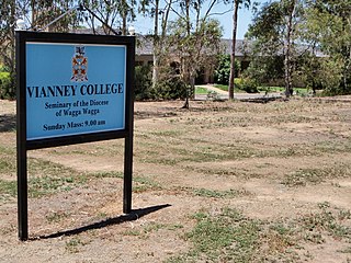
Boorooma is a suburb of Wagga Wagga, New South Wales, Australia, located in the city's north, beyond the floodplains of the Murrumbidgee River. The locality is a southern neighbour of Charles Sturt University—which in fact is referred to as 'Boorooma Campus' and is located directly to the east of the suburb of Estella and to the north of the Olympic Highway. Boorooma is progressively undergoing transition from rural residential type allotments to more intensive urban residential uses. Boorooma is also home to Vianney College Seminary and The Riverina Anglican College, and has land zoned for a future shopping centre.

Cartwrights Hill is a north-eastern suburb of Wagga Wagga, New South Wales, Australia. It is located immediately to the west of the industrial suburb of Bomen, which has, due to Bomen's shift towards heavier industries, led to the suburb's development being halted. The Red Steer Hotel/Motel is located in Cartwrights Hill.
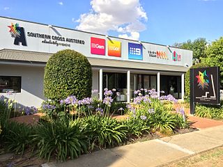
Triple M Riverina is an Australian radio station which transmits on 1152 kHz on the AM band. It is licensed to the city of Wagga Wagga, New South Wales. The station is the first radio station to have a radio receiver built in regional New South Wales and was originally owned by a husband and wife team, the late Eric and Nan Roberts, who were both formerly school teachers in Narrandera. It officially commenced broadcasts from the former Hardys' Building in Fitzmaurice Street overlooking the Wollundry Lagoon, broadcasting on the Oura Road Transmitter site with 2,000 watts on 29 June 1932 and operated between 6.00 am and 11.00 pm. In 1995 2WZD (FM93) began broadcasting.

East Wagga Wagga is a suburb of Wagga Wagga, New South Wales. East Wagga Wagga is mostly an industrial area located approximately 3 km (2 mi) east south-east of the central business district on the Sturt Highway. Home Base Wagga Wagga, WIN Television, Country Energy depot, Riverina Water County Council headquarters, Australia Post Mail Sorting Centre, Busabout Wagga Wagga depot, Australian Clay Target Association (ACTA) National Office and ACTA shooting range are located within East Wagga Wagga.

Charles Sturt University is a suburb and location for Charles Sturt University's Wagga Wagga Campus is located in the suburb of Estella.
Gobbagombalin is a predominantly farming community in the central east part of the Riverina and a suburb of Wagga Wagga. A portion of Gobbagombalin adjacent to the suburb of Estella and to the North of Old Narrandera Road was rezoned for residential purposes under the Wagga Wagga Local Environmental Plan 2010 in July 2010, with suburban development of area commencing in 2013. The suburban part of Gobbagombalin is being marketed under various names including Estella Rise and Estella Heights, as well as Gobbagombalin, despite Estella being a separate locality further to the east of Gobbagombalin.

