
Albury is a major regional city in New South Wales, Australia. It is located on the Hume Highway and the northern side of the Murray River. Albury is the seat of local government for the council area which also bears the city's name – the City of Albury. It is on the Victoria–New South Wales border.

Wagga Wagga is a major regional city in the Riverina region of New South Wales, Australia. Straddling the Murrumbidgee River, with an urban population of more than 56,000 as of June 2018, Wagga Wagga is the state's second largest inland city after Maitland, and is an important agricultural, military, and transport hub of Australia. The ninth largest inland city in Australia, Wagga Wagga is located midway between the two largest cities in Australia—Sydney and Melbourne—and is the major regional centre for the Riverina and South West Slopes regions.

Harden–Murrumburrah is a township and community in the Hilltops Region and is located in the South West Slopes of New South Wales in Australia. Harden is adjacent to both the Canberra region of the Australian Capital Territory and the Riverina Region in the southwest area of NSW. The town is a twin town between Harden and Murrumburrah.

Forrestfield is a suburb of the City of Kalamunda in Western Australia. It lies 15 kilometres to the south-east of Perth at the base of the Darling Scarp and the southern border of Perth Airport.

Junee is a medium-sized town in the Riverina region of New South Wales, Australia. The town's prosperity and mixed services economy is based on a combination of agriculture, rail transport, light industry and government services, and in particular correctional services. In 2015 Junee's urban population was 4,762.

Cootamundra, nicknamed Coota, is a town in the South West Slopes region of New South Wales, Australia and within the Riverina. It is within the Cootamundra-Gundagai Regional Council. At the 2016 Census, Cootamundra had a population of 6,782. It is located on the Olympic Highway at the point where it crosses the Muttama Creek, between Junee and Cowra. Its railway station is on the Main Southern line, part of the Melbourne-to-Sydney line.

Moss Vale is a town in the Southern Highlands of New South Wales, Australia, in the Wingecarribee Shire. It is located on the Illawarra Highway, which connects to Wollongong and the Illawarra coast via Macquarie Pass.

A dry port is an inland intermodal terminal directly connected by road or rail to a seaport, operating as a centre for the transshipment of sea cargo to inland destinations.

Grong Grong is a small town that is located in the Riverina region of New South Wales, Australia. The town is situated on the Newell Highway, 23 kilometres (14 mi) east of Narrandera in the Shire of Narrandera.

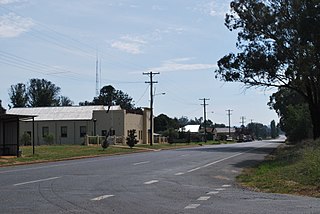
Culcairn is a town in the south-east Riverina region of New South Wales, Australia. Culcairn is located in the Greater Hume Shire local government area on the Olympic Highway between Albury and Wagga Wagga. The towns Longest serving Mayor of 25 years Oscar Willis prides his hometown having been there since 1945, Sydney and at the 2016 census had a population of 1,473.

Wagga Wagga railway station is a railway station open for passenger services on the Main South line connecting Sydney and Melbourne. It has been heritage-listed, especially on account of its historical and architectural significance. A museum is on the premises. As of 2021, two daily passenger trains in each direction served the City of Wagga Wagga.
Ladysmith is a village approximately 19 km east of Wagga Wagga in the Riverina region of New South Wales, Australia. At the 2016 census, Ladysmith had a population of 352 people.

Albury railway station is a heritage-listed railway station at Railway Place, Albury, New South Wales, Australia, adjacent to the border with Victoria, in Australia. It was designed under the direction of John Whitton and built from 1880 to 1881. It was added to the New South Wales State Heritage Register in 1999.

City of Wagga Wagga is a local government area in the Riverina region of southern New South Wales, Australia.

Rosewood is a village community and locality in the south east part of the Riverina, New South Wales, Australia. It is situated about 16 kilometres (9.9 mi) south east from Carabost and 19 kilometres (12 mi) north west from Tumbarumba. At the 2016 census, Rosewood had a population of 214. The village is administered by two local governments; the northern part of the locality by the Greater Hume Shire and the southern part of the locality by the Snowy Valleys Council. The village of Rosewood is within the Snowy Valleys Council area.
The history of Wagga Wagga details the growth of the city from a small crossing on the Murrumbidgee River to the largest city and regional centre of the Riverina region of New South Wales, Australia.

The Bomen railway station is a heritage-listed closed railway station located on the Main South line in Bomen in the City of Wagga Wagga local government area of New South Wales, Australia. The property was added to the New South Wales State Heritage Register on 2 April 1999. Passenger trains no longer stop at the station.
Gobbagombalin is a predominantly farming community in the central east part of the Riverina and a suburb of Wagga Wagga. A portion of Gobbagombalin adjacent to the suburb of Estella and to the North of Old Narrandera Road was rezoned for residential purposes under the Wagga Wagga Local Environmental Plan 2010 in July 2010, with suburban development of area commencing in 2013. The suburban part of Gobbagombalin is being marketed under various names including Estella Rise and Estella Heights, as well as Gobbagombalin, despite Estella being a separate locality further to the east of Gobbagombalin.
The Moorebank Intermodal Terminal is an intermodal terminal under construction in the south-western Sydney suburb of Moorebank.
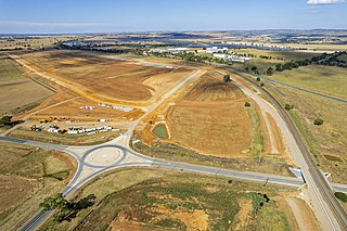
The Riverina Intermodal Freight and Logistics Hub is an under construction Australian dry port in the northern Wagga Wagga suburb of Bomen adjacent to the Main Southern railway line.

