Boyd County, New South Wales

Last updated

Map all coordinates using: OpenStreetMap  
Download coordinates as: KML  ·  GPX
Boyd
New South Wales
Boyd NSW.PNG
Location in New South Wales
Lands administrative divisions around Boyd:
Waradgery Sturt Cooper
Waradgery Boyd Mitchel
Townsend Urana Urana
Boyd County NSW as shown on John Sands 1886 map). Boyd County NSW (John Sands 1886 map).png
Boyd County NSW as shown on John Sands 1886 map).

Boyd County is one of the 141 Cadastral divisions of New South Wales. It contains the locality of Coleambally. The Murrumbidgee River is the northern boundary.

Murrumbidgee River river in New South Wales, Australia

Murrumbidgee River, a major tributary of the Murray River within the Murray–Darling basin and the second longest river in Australia. It flows through the Australian state of New South Wales and the Australian Capital Territory. It descends 1,500 metres (4,900 ft) as it flows 1,485 kilometres (923 mi) in a west-northwesterly direction from the foot of Peppercorn Hill in the Fiery Range of the Snowy Mountains towards its confluence with the Murray River near Boundary Bend.

Boyd County was named in honour of Benjamin Boyd, entrepreneur (1796-1851). [2]

Benjamin Boyd was a Scottish-born Australian shipowner, banker, pioneer and entrepreneur, and briefly, a politician.

The Carathool Bridge over the Murrumbidgee between Boyd and Sturt CarrathoolBridge.JPG
The Carathool Bridge over the Murrumbidgee between Boyd and Sturt

Parishes within this county

A full list of parishes found within this county; their current LGA and mapping coordinates to the approximate centre of each location is as follows:

Local government in Australia

Local government in Australia is the third tier of government in Australia administered by the states and territories, which in turn are beneath the federal tier. Local government is not mentioned in the Constitution of Australia and two referenda in the 1970s and 1980s to alter the Constitution relating to local government were unsuccessful. Every state government recognises local government in their respective constitutions. Unlike Canada or the United States, there is only one level of local government in each state, with no distinction such as cities and counties.

ParishLGACoordinates
Argoon Murrumbidgee Council 34°50′54″S145°54′04″E / 34.84833°S 145.90111°E / -34.84833; 145.90111 (Argoon)
Banandra Murrumbidgee Council 34°45′54″S146°10′04″E / 34.76500°S 146.16778°E / -34.76500; 146.16778 (Banandra)
Boona Murrumbidgee Council 34°46′54″S145°58′04″E / 34.78167°S 145.96778°E / -34.78167; 145.96778 (Boona)
Boyd Murrumbidgee Council 34°47′54″S145°22′04″E / 34.79833°S 145.36778°E / -34.79833; 145.36778 (Boyd)
Burt Leeton Shire Council 34°39′54″S146°16′04″E / 34.66500°S 146.26778°E / -34.66500; 146.26778 (Burt)
Cararbury Murrumbidgee Council 34°36′54″S145°48′04″E / 34.61500°S 145.80111°E / -34.61500; 145.80111 (Cararbury)
Clifford Murrumbidgee Council 34°40′54″S145°40′04″E / 34.68167°S 145.66778°E / -34.68167; 145.66778 (Clifford)
Coleambally Murrumbidgee Council 34°47′54″S145°47′04″E / 34.79833°S 145.78444°E / -34.79833; 145.78444 (Coleambally)
Dow Murrumbidgee Council 34°39′54″S145°35′04″E / 34.66500°S 145.58444°E / -34.66500; 145.58444 (Dow)
Duderbang Murrumbidgee Council 34°41′54″S145°47′04″E / 34.69833°S 145.78444°E / -34.69833; 145.78444 (Duderbang)
Eilginbah Murrumbidgee Council 34°33′54″S145°25′04″E / 34.56500°S 145.41778°E / -34.56500; 145.41778 (Eilginbah)
Eulo Murrumbidgee Council 34°45′54″S146°04′04″E / 34.76500°S 146.06778°E / -34.76500; 146.06778 (Eulo)
Eunanbrennan Murrumbidgee Council 34°31′54″S145°40′04″E / 34.53167°S 145.66778°E / -34.53167; 145.66778 (Eunanbrennan)
Gidgell Murrumbidgee Council 34°51′54″S146°05′04″E / 34.86500°S 146.08444°E / -34.86500; 146.08444 (Gidgell)
Glengalla Murrumbidgee Council 34°44′54″S145°23′04″E / 34.74833°S 145.38444°E / -34.74833; 145.38444 (Glengalla)
Gumblebogie Murrumbidgee Council 34°47′54″S145°33′04″E / 34.79833°S 145.55111°E / -34.79833; 145.55111 (Gumblebogie)
Gundadaline Murrumbidgee Council 34°40′54″S145°31′04″E / 34.68167°S 145.51778°E / -34.68167; 145.51778 (Gundadaline)
Howell Narrandera Shire Council 34°49′54″S146°13′04″E / 34.83167°S 146.21778°E / -34.83167; 146.21778 (Howell)
Jurambula Murrumbidgee Council 34°39′54″S146°10′04″E / 34.66500°S 146.16778°E / -34.66500; 146.16778 (Jurambula)
Kabarabarabejal Murrumbidgee Council 34°47′54″S145°16′04″E / 34.79833°S 145.26778°E / -34.79833; 145.26778 (Kabarabarabejal)
Macleay Murrumbidgee Council 34°38′54″S145°24′04″E / 34.64833°S 145.40111°E / -34.64833; 145.40111 (Macleay)
Maley Murrumbidgee Council 34°47′54″S145°40′04″E / 34.79833°S 145.66778°E / -34.79833; 145.66778 (Maley)
Mulberrygong Murrumbidgee Council 34°31′54″S145°18′04″E / 34.53167°S 145.30111°E / -34.53167; 145.30111 (Mulberrygong)
Mulburruga Murrumbidgee Council 34°28′54″S145°25′04″E / 34.48167°S 145.41778°E / -34.48167; 145.41778 (Mulburruga)
Mycotha Murrumbidgee Council 34°45′54″S145°54′04″E / 34.76500°S 145.90111°E / -34.76500; 145.90111 (Mycotha)
Oolambeyan Murrumbidgee Council 34°41′54″S145°16′04″E / 34.69833°S 145.26778°E / -34.69833; 145.26778 (Oolambeyan)
Ourendumbee Narrandera Shire Council 34°44′54″S146°16′04″E / 34.74833°S 146.26778°E / -34.74833; 146.26778 (Ourendumbee)
Peter Murrumbidgee Council 34°49′54″S145°48′04″E / 34.83167°S 145.80111°E / -34.83167; 145.80111 (Peter)
Puckinevvy Murrumbidgee Council 34°35′54″S145°32′04″E / 34.59833°S 145.53444°E / -34.59833; 145.53444 (Puckinevvy)
Singorambah Murrumbidgee Council 34°29′54″S145°37′04″E / 34.49833°S 145.61778°E / -34.49833; 145.61778 (Singorambah)
Toganmain Murrumbidgee Council 34°28′54″S145°31′04″E / 34.48167°S 145.51778°E / -34.48167; 145.51778 (Toganmain)
Tubbo Murrumbidgee Council 34°39′54″S146°05′04″E / 34.66500°S 146.08444°E / -34.66500; 146.08444 (Tubbo)
Ugobit Murrumbidgee Council 34°41′54″S145°53′04″E / 34.69833°S 145.88444°E / -34.69833; 145.88444 (Ugobit)
Uri Murrumbidgee Council 34°36′54″S145°54′04″E / 34.61500°S 145.90111°E / -34.61500; 145.90111 (Uri)
Uroly Leeton Shire Council 34°41′54″S146°20′04″E / 34.69833°S 146.33444°E / -34.69833; 146.33444 (Uroly)
Waddaduri Murrumbidgee Council 34°34′54″S145°36′04″E / 34.58167°S 145.60111°E / -34.58167; 145.60111 (Waddaduri)
Waddi Murrumbidgee Council 34°40′54″S145°58′04″E / 34.68167°S 145.96778°E / -34.68167; 145.96778 (Waddi)
Wangabawgul Murrumbidgee Council 34°46′54″S145°29′04″E / 34.78167°S 145.48444°E / -34.78167; 145.48444 (Wangabawgul)
Wolseley Murrumbidgee Council 34°36′54″S145°18′04″E / 34.61500°S 145.30111°E / -34.61500; 145.30111 (Wolseley)

Related Research Articles

Kanangra-Boyd National Park Protected area in New South Wales, Australia

The Kanangra-Boyd National Park is a protected national park that is located in the Central Tablelands region, west of the Southern Highlands and Macarthur regions, in New South Wales, in eastern Australia. The 68,660-hectare (169,700-acre) national park is situated approximately 180 kilometres (110 mi) south-west of Sydney and is contiguous with the Blue Mountains National Park and the Nattai National Park. The park was established in 1969.

The Geographical Names Board of New South Wales, a statutory authority of the Land and Property Information division, Department of Finance and Services in the Government of New South Wales, is the official body for naming and recording details of places and geographical names in the state of New South Wales, Australia.

Kanangra Falls waterfall

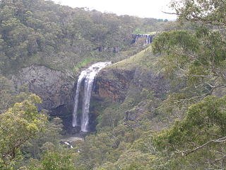
Kanangra Falls is a waterfall on the Kanangra River, in the Kanangra-Boyd National Park, near Oberon, in the Central Tablelands of New South Wales, Australia. The waterfall is located at Thurat Walls about 800 metres (2,600 ft) north east of Ianthe Hill; with the fall height reported in 1930 as being 225 metres in two sections.

Black Banksia Falls

The Black Banksia Falls is a waterfall that is located within the Kanangra-Boyd National Park in the Central Tablelands region of New South Wales, Australia.

Darbalara, New South Wales Town in New South Wales, Australia

Darbalara is a rural community on the east bank of the junction of the Murrumbidgee River and Tumut River in the Riverina. It is situated by road, about 25 kilometres north east of Gundagai and 25 kilometres south of Coolac.

Westmoreland County, New South Wales Cadastral in New South Wales, Australia

Westmoreland County was one of the original Nineteen Counties in New South Wales and is now one of the 141 Cadastral divisions of New South Wales. It is to the west of Sydney in the Blue Mountains. Coxs River is the border to the north, and the Wollondilly River to the east. Campbells River is the border in the north-east, where the county extends to near Bathurst, with the Fish River part of the border. It includes the town of Oberon, and the Kanangra-Boyd National Park.

Cowper County Cadastral in New South Wales, Australia

Cowper County, New South Wales is one of the 141 Cadastral divisions of New South Wales.

Jones Beach (New South Wales)

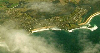
Jones Beach, also known as Boyds Beach, is a beach on the south-eastern coast of Australia, facing the Tasman Sea. The beach is east of the settlement of Kiama Downs and about 2 kilometres (1.2 mi) south by east of the settlement of Minnamurra in the Illawarra and South Coast regions of New South Wales.

Guy Fawkes River

Guy Fawkes River, a perennial stream that is part of the Clarence River catchment, is in the New England and Northern Tablelands districts of New South Wales, Australia.

Nymboida River river in New South Wales, Australia

The Nymboida River, a perennial stream of the Clarence River catchment, is located in the Northern Rivers region of New South Wales, Australia.

Bendoc River

The Bendoc River is a perennial river of the Snowy River catchment, located in the Alpine regions of the states of Victoria and New South Wales, Australia.

Boyd River, a perennial stream that is part of the Clarence River catchment, is located in the Northern Tablelands district of New South Wales, Australia.

Henry River, a perennial stream of the Clarence River catchment, is located in the Northern Tablelands district of New South Wales, Australia.

The Kowmung River, a perennial river that is part of the Hawkesbury-Nepean catchment, is located in the Central Tablelands region of New South Wales, Australia.

Sara River, a perennial stream that is part of the Clarence River catchment, is located in the New England and Northern Tablelands districts of New South Wales, Australia.

The Tonalli River, a perennial river that is part of the Hawkesbury-Nepean catchment, is located in the Blue Mountains region of New South Wales, Australia.

The Wonboyn River, an open youthful wave dominated barrier estuary or perennial stream, is located in the South Coast region of New South Wales, Australia.

The Little River, a perennial river that is part of the Hawkesbury-Nepean catchment, is located in the Central Tablelands region of New South Wales, Australia.

The Chandlers Creek, a perennial stream that is part of the Clarence River catchment, is located in the Northern Tablelands region of New South Wales, Australia.

Kanangra Creek river in Australia

The Kanangra Creek, a perennial stream of the Hawkesbury-Nepean catchment, is located in the Blue Mountains region of New South Wales, Australia.

References

  1. The New atlas of Australia (John Sands 1886) map 21.
  2. "Boyd County". Geographical Names Register (GNR) of NSW. Geographical Names Board of New South Wales. OOjs UI icon edit-ltr-progressive.svg