
Jerilderie is a town in the southern Riverina region of New South Wales, Australia. It is the largest town in the Murrumbidgee Council local government area. At the 2016 census, Jerilderie had 1,029 people.

Tocumwal is a town in the southern Riverina region of New South Wales, Australia, in the Berrigan Shire local government area, near the Victorian border. The town is situated on the banks of the Murray River, 270 kilometres (170 mi) north of the city of Melbourne. The Newell Highway and Murray Valley Highway join at the Murray River, and form part of the main road route National Highway A39 between Brisbane and Melbourne. At the 2016 census, Tocumwal had a population of 2,682.. The winner of several ‘Tidy Town’ awards, Tocumwal is affectionately known as ‘The Jewel In The Crown That Is The Riverina District’.

Quirindi is a small town on the North West Slopes region of New South Wales, Australia, in Liverpool Plains Shire. At the 2011 census, Quirindi had a population of 2,580. It is the nearest link to Gunnedah to the west and Tamworth to the north. The local economy is based on agriculture, with broadacre farming dominant on the black soil plains to the west and livestock grazing in the hilly eastern part of the district.

Berrigan is a town on the Riverina Highway in the Riverina region of New South Wales, Australia. Berrigan is in the Berrigan Shire local government area and contains the Berrigan Shire Council offices. At the 2016 census, Berrigan had a population of 1,260.

Collingullie is a village 26 kilometres (16 mi) north-west of Wagga Wagga in the Riverina region of New South Wales, Australia. The village is located on the Sturt Highway, between Wagga Wagga and Narrandera, at the crossroads with the road to Lockhart.
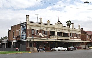
Yenda is a town in the Riverina district of New South Wales, Australia. The town is located about 16 kilometres (9.9 mi) east of Griffith, 65 kilometres (40 mi) north-west of Narrandera, and 550 kilometres (340 mi) west of Sydney in the Murrumbidgee Irrigation Area of southern New South Wales. Although most of the original 15-acre farms have been consolidated into large vineyards and most farmhouses have disappeared, farm roads are named after the original settlers. In 1940 Yenda had two clothing stores, two bakers, two butchers, two grocery stores, two barbers, one newsagency, one pharmacy, one cinema, one Greek restaurant and one bank but residents now do their shopping in nearby Griffith. At the 2011 census, Yenda had a population of 1,503.

Cookardinia is a locality in the Riverina region of New South Wales, Australia. The locality is 57 kilometres (35 mi) south of the regional city of Wagga Wagga and 24 kilometres (15 mi) east of the town of Henty. Its surrounding area has an approximate population of 283 persons.

Mitta Mitta is a farming community in the north eastern part of the Riverina. It is situated by road, about 30 kilometres (19 mi) south of Bethungra and 21 kilometres (13 mi) north east of Nangus.
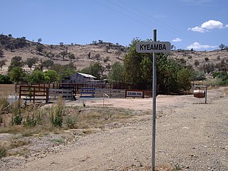
Kyeamba is a farming community in the central east part of the Riverina and situated about 16 kilometres (9.9 mi) north west of Humula and 23 kilometres (14 mi) south west of Tarcutta. At the 2016 census, Kyeamba had a population of 54.
Woolgarlo is a locality on the foreshores of the Yass River arm of Lake Burrinjuck, in the far eastern part of the Riverina in the Yass Valley Shire of New South Wales, Australia. At the 2016 census, it had a population of 26.

Morundah is a small town in the Murray region of New South Wales, Australia. The town is located on the Newell Highway and in the Federation Council local government area. The town consists of a hotel, some silos and a few houses. At the 2016 census, Morundah had a population of 22.
Yallakool is an unbounded village community within the locality of Caldwell in the central south part of the Riverina. It is situated by road about 10 kilometres (6.2 mi) north west of Caldwell and 50 kilometres (31 mi) west of Deniliquin, but is a part of the Murray River Council.
Bowna is a locality in the South East part of the Riverina, New South Wales, Australia.

Wymah is a rural community in the south-east part of the Riverina very close to the border of Victoria, Australia. It is situated by road, about 11 kilometres (7 mi) south of Bowna and 23 kilometres (14 mi) west of Talmalmo. Wymah is situated on the Wymah River Road accessible from Bowna. At the 2016 census, Wymah had a population of 37.

Mirrool is a town in the northern part of the Riverina region of south-west New South Wales, Australia. The town is in the Bland Shire local government area and adjacent to the Newell Highway, 473 kilometres (294 mi) south west of the state capital, Sydney. At the 2011 census, Mirrool and the surrounding area had a population of 234.
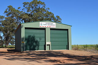
Colinroobie is a rural community in the central part of the Riverina in southern New South Wales, Australia. Previously referred to as Bents Hill its name was changed in January 2005.

Milbrulong is a locality in the central east part of the Riverina region of New South Wales, Australia. The locality is 515 kilometres (320 mi) south west of the state capital, Sydney and 59 kilometres (37 mi) south west of the regional centre Wagga Wagga in the Lockhart Shire local government area. The standard gauge Oaklands railway line passes through the locality.
Bundure is a rural community in the central south part of the Riverina. It is situated by road, about 25 kilometres south west of Widgiewa and 33 kilometres north east of Jerilderie. In 2006, Bundure had a population of 274 people.

The Tocumwal railway line is a closed railway line in New South Wales, Australia. The line branched from the still open Junee - Hay line at Narrandera station and then headed south west to Tocumwal station where there was a break-of-gauge with the Victorian Railways Goulburn Valley line from Shepparton.
The Tocumwal railway station is a heritage-listed closed railway station in the town of Tocumwal, New South Wales, Australia. It was once the break-of-gauge between the broad gauge Victorian Railways Tocumwal line from the south, and the standard gauge New South Wales Government Railways Tocumwal line from the north. However, only the line from Victoria is still open.

