
Young is a town in the South Western Slopes region of New South Wales, Australia and the largest town in the Hilltops Region. The "Lambing Flat" Post Office opened on 1 March 1861 and was renamed "Young" in 1863.

Lismore is a city located in the Northern Rivers region of New South Wales, Australia and the main population centre in the City of Lismore local government area, it is also a regional centre in the Northern Rivers region of the state. Lismore is 734 km (456 mi) north of Sydney and 200 km (120 mi) south of Brisbane. It is situated on a low floodplain on the banks of the Wilsons River near the latter's junction with Leycester Creek, both tributaries of the Richmond River which enters the Pacific Ocean at Ballina, 30 km (19 mi) to the east.

Coolah is a town in the central western part of New South Wales, Australia in Warrumbungle Shire. At the 2016 census, Coolah had a population of 1,290. The name Coolah is derived from the Port Jackson Pidgin English word meaning "angry".
Narrandera, until around 1949 also spelled "Narandera", is a town located in the Riverina region of southern New South Wales, Australia. The town lies on the junction of the Newell and Sturt highways, adjacent to the Murrumbidgee River, and it is considered the gateway to the Murrumbidgee Irrigation Area. At the 2016 census, Narrandera had a population of 3,746 people.

Cooma is a town in the south of New South Wales, Australia. It is located 114 kilometres (71 mi) south of the national capital, Canberra, via the Monaro Highway. It is also on the Snowy Mountains Highway, connecting Bega with the Riverina.

North Sydney is a suburb and major commercial district on the Lower North Shore of Sydney, New South Wales, Australia. It is located three kilometres north of the Sydney central business district and is the administrative centre for the local government area of North Sydney Council.

Macksville is a small town on the Nambucca River in the Nambucca Valley, New South Wales, Australia. It is halfway between Sydney and Brisbane, along the Pacific Highway, approximately 40 minutes north of Kempsey, 40 minutes south of Coffs Harbour, 70 minutes north of Port Macquarie, five hours south of Brisbane and five hours north of Sydney.

Junee is a medium-sized town in the Riverina region of New South Wales, Australia. The town's prosperity and mixed services economy is based on a combination of agriculture, rail transport, light industry and government services, and in particular correctional services. In 2015 Junee's urban population was 4,762.

Euston is a small town on the banks of the Murray River, in the Murray region in southern New South Wales, Australia in Balranald Shire. The twin town of Robinvale is on the other side of the river in the state of Victoria.

Finley is a town in the Riverina region of New South Wales, Australia. It is the largest town in the Berrigan Shire local government area. At the 2016 census, Finley had a population of 2,519 people. The town is located approximately 140 kilometres (87 mi) west of Albury on the intersection of the Newell Highway and Riverina Highways.

Grenfell is a town in Weddin Shire in the Central West of New South Wales, Australia. It is 370 km (230 mi) west of Sydney. It is close to Forbes, Cowra and Young. At the 2011 census, Grenfell had a population of 1,996. The town is served daily by connecting NSW TrainLink services from Sydney via Bathurst and Lithgow. Grenfell is approximately 5 hours from Sydney and 2+1⁄2 hours from Canberra.

Quirindi is a small town on the North West Slopes region of New South Wales, Australia, in Liverpool Plains Shire. At the 2016 census, Quirindi had a population of 3,444. It is the nearest link to Gunnedah to the northwest and Tamworth to the north. The local economy is based on agriculture, with broadacre farming dominant on the black soil plains to the west and livestock grazing in the hilly eastern part of the district.

Temora is a town in the north-east of the Riverina area of New South Wales, 418 kilometres (260 mi) south-west of the state capital, Sydney. At the 2021 census the population of Temora was 4,016.

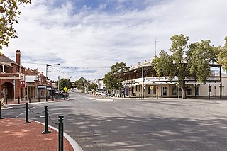
Henty is a town in southwestern New South Wales close to the boundaries of the South West Slopes and the Riverina districts, almost midway between the regional cities of Albury and Wagga Wagga. At the 2006 census, Henty had a population of 863 people.

Whitton is a small town located in Leeton Shire in the Australian state of New South Wales and is located 23km west of the Leeton township. Founded in 1850, it is named after John Whitton (1820–98), Engineer-in-Charge of the New South Wales Government Railways. The railway reached Whitton in 1881. At the 2016 census, Whitton had a population of 496.

Berrigan is a town on the Riverina Highway in the Riverina region of New South Wales, Australia. Berrigan is in the Berrigan Shire local government area and contains the Berrigan Shire Council offices. At the 2016 census, Berrigan had a population of 1,260.
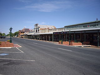
Lockhart is a town in the Riverina Region of New South Wales, Australia. It is the location of the Lockhart Shire Council offices. At the 2016 census, Lockhart had a population of 818 people.
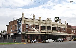
Yenda is a town in the Riverina district of New South Wales, Australia. The town is located about 16 kilometres (9.9 mi) east of Griffith, 65 kilometres (40 mi) north-west of Narrandera, and 550 kilometres (340 mi) west of Sydney in the Murrumbidgee Irrigation Area of southern New South Wales. Although most of the original 15-acre farms have been consolidated into large vineyards and most farmhouses have disappeared, farm roads are named after the original settlers. In 1940 Yenda had two clothing stores, two bakers, two butchers, two grocery stores, two barbers, one newsagency, one pharmacy, one cinema, one Greek restaurant and one bank but residents now do their shopping in nearby Griffith. At the 2011 census, Yenda had a population of 1,503.

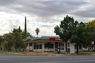
Morven is a small village about 7 kilometres east of Culcairn in the eastern Riverina district of New South Wales, Australia. At the 2021 census, Morven has a population of 125 people.
Hanwood is a town in the central Riverina region of New South Wales, Australia. The town is located 5 kilometres south of Griffith, New South Wales and is in the City of Griffith local government area. At the 2021 census, Hanwood had a population of 1,388.

